Colorado Wetland Information Center Logo Colorado Wetland Information Center Logo CWIC
  • About CWIC
    • What Are Wetlands?
    • Why Are Wetlands Important?
    • Colorado Wetland Plan
    • Wetland Partners
  • Wetland Types
    • Overview
    • Ecological Systems
    • Natural Plant Communities
    • Field Guides and App
    • Fen Mapping
  • Wetland Condition
    • Overview
    • Ecological Condition
    • Habitat Quality
    • Biodiversity Significance
    • Colorado Wetland Assessment Projects
    • National Wetland Condition Assessment
    • BLM Assessment Inventory and Monitoring
  • Working in Wetlands
    • Overview
    • Conservation
    • Restoration
    • Regulation
    • Best Management Practices
    • Funding and Technical Support
  • Data & Tools
    • Wetlands Mapper
    • Floristic Quality Calculator
    • Landscape Summaries
    • Watershed Toolbox
    • Wetland Plots Database
  • Library
    • Wetland Reports
    • Potential Conservation Areas
    • County Survey Reports
    • Field Guides and App
    • Field Manuals
    • Educational Resources
  • CNHP Home

Landscape Summaries

Four different summary reports are available for each geographic area:

  • Wetland profiles that describe the general geography of the area, the extent of wetland mapping, and the acreage of various wetland classes mapped by National Wetland Inventory
  • A list of CNHP’s wetland and riparian dependent PCAs within the area, including a link to the individual PCA reports
  • A list of CNHP’s tracked wetland and riparian dependent elements (plants, animals, and natural communities) found within the area, including a count of known occurrences
  • A list of CNHP reports for projects that include information on wetland and riparian areas either within the specific area or applicable across the state or region
Wetland_at_Fourmile_Ranch_archuleta_county

To access the profiles and summary reports, first select a geographic scale.

Click on a Major River Basin from the map, or choose from the list below.
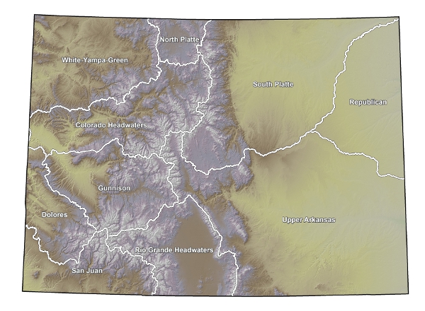
Colorado HeadwatersGunnisonNorth PlatteRepublicanRio Grande HeadwatersSouth PlatteUpper ArkansasUpper Colorado-DoloresUpper San JuanWhite-Yampa-Green
  • Colorado Headwaters
  • Gunnison
  • North Platte
  • Republican
  • Rio Grande Headwaters
  • South Platte
  • Upper Arkansas
  • Upper Colorado-Dolores
  • Upper San Juan
  • White-Yampa-Green

Colorado Headwaters

  • Colorado Headwaters
  • Blue
  • Eagle
  • Roaring Fork
  • Colorado Headwaters-Plateau

Gunnison

  • East-Taylor
  • Upper Gunnison
  • Tomichi
  • North Fork Gunnison
  • Lower Gunnison
  • Uncompahange

North Platte

  • North Platte Headwaters
  • Upper North Platte
  • Upper Laramie

Republican

  • Arikaree
  • North Fork Republican
  • South Fork Republican
  • Frenchman
  • Stinking Water
  • South Fork Beaver
  • Little Beaver
  • Smoky Hill Headwaters
  • North Fork Smoky Hill
  • Ladder

Rio Grande Headwaters

  • Rio Grande Headwaters
  • Alamosa-Trinchera
  • San Luis
  • Saguache
  • Conejos
  • Upper Rio Grande
  • Rio Chama

South Platte

  • South Platte Headwater
  • Upper South Platte
  • Middle South Platte-Cherry Creek
  • Clear Creek
  • St. Vrain
  • Big Thompson
  • Cache La Poudre
  • Lone Tree-Owl
  • Crow
  • Kiowa
  • Bijou
  • Middle South Platte-Sterling
  • Beaver
  • Pawnee
  • Upper Lodgepole
  • Lower Lodgepole
  • Sidney Draw
  • Lower South Platte

Upper Arkansas

  • Arkansas Headwaters
  • Upper Arkansas
  • Fountain
  • Chico
  • Upper Arkansas-Lake Meredith
  • Huerfano
  • Apishapa
  • Horse
  • Upper Arkansas-John Martin Reservoir
  • Purgatorie
  • Big Sandy
  • Rush
  • Two Butte
  • Middle Arkansas-Lake McKinney
  • Whitewoman
  • Cimarron Headwaters
  • Upper Cimarron
  • North Fork Cimarron
  • Sand Arroyo
  • Bear
  • Canadian Headwaters

Upper Colorado-Dolores

  • Westwater Canyon
  • Upper Dolores
  • San Miguel
  • Lower Dolores
  • Upper Colorado-Kane Springs

Upper San Juan

  • Upper San Juan
  • Piedra
  • Animas
  • Middle San Juan
  • Mancos
  • Lower San Juan-Four Corners
  • McElmo
  • Montezuma

White-Yampa-Green

  • Upper Green-Flaming Gorge Reservoir
  • Vermilion
  • Upper Yampa
  • Lower Yampa
  • Little Snake
  • Upper White
  • Piceance-Yellow
  • Lower White
  • Lower Green-Diamond

Click on a County from the map, or choose from the list below.
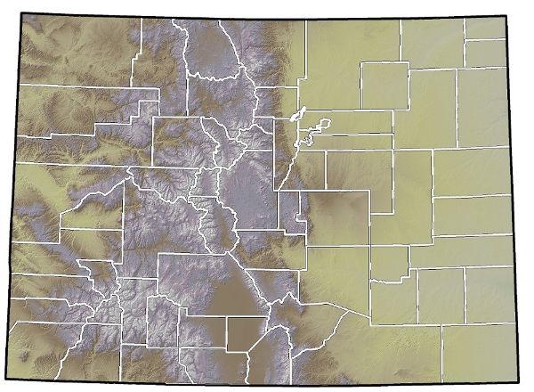
AdamsAlamosaArapahoeArchuletaBacaBentBoulderBroomfieldChaffeeCheyenneClear creekConejosCostillaCrowleyCusterDeltaDenverDoloresDouglasEagleEl PasoElbertFremontGarfieldGilpinGrandGunnisonHinsdaleHuerfanoJacksonJeffersonKiowaKit CarsonLa PlataLakeLarimerLas AnimasLincolnLoganMesaMineralMoffatMontezumaMontroseMorganOteroOurayParkPhillipsPitkinProwersPuebloRio BlancoRio GrandeRouttSaguacheSan JuanSan MiguelSedgwickSummitTellerWashingtonWeld Yuma
  • Adams
  • Alamosa
  • Arapahoe
  • Archuleta
  • Baca
  • Bent
  • Boulder
  • Broomfield
  • Chaffee
  • Cheyenne
  • Clear creek
  • Conejos
  • Costilla
  • Crowley
  • Custer
  • Delta
  • Denver
  • Dolores
  • Douglas
  • Eagle
  • El Paso
  • Elbert
  • Fremont
  • Garfield
  • Gilpin
  • Grand
  • Gunnison
  • Hinsdale
  • Huerfano
  • Jackson
  • Jefferson
  • Kiowa
  • Kit Carson
  • La Plata
  • Lake
  • Larimer
  • Las Animas
  • Lincoln
  • Logan
  • Mesa
  • Mineral
  • Moffat
  • Montezuma
  • Montrose
  • Morgan
  • Otero
  • Ouray
  • Park
  • Phillips
  • Pitkin
  • Prowers
  • Pueblo
  • Rio Blanco
  • Rio Grande
  • Routt
  • Saguache
  • San Juan
  • San Miguel
  • Sedgwick
  • Summit
  • Teller
  • Washington
  • Weld
  • Yuma

Wetland Data & Tools

Wetlands Mapper
Floristic Quality Calculator
Landscape Summaries
Watershed Toolbox
Wetland Plots Database

Related Topics

Wetland Reports
PCA Reports
County Survey Reports
Field Guides and App
Field Manuals
Educational Resources
Watershed Toolbox

Web Projects

  • CODEX - Colorado’s Conservation Data Explorer
  • Rare Plant Guide Online
  • Colorado Wetland Info Center
  • COMaP - Colorado Protected Lands
  • Colorado Bat Working Group
  • STReaMS - Endangered Fishes Database
  • Colorado Native Plant Database Data Portal

About Us

  • About Us
  • Conserving Biodiversity
  • Contact Us
  • Staff Directory
  • Careers
  • Site Map
Warner College of Natural Resources Logo
  • Apply to CSU
  • Equal Opportunity
  • Disclaimer
  • Privacy Statement
  • Search CSU
  • CSU Land Acknowledgement
  • CSU Principles of Community
© 2025 Colorado Natural Heritage Program
Colorado State University Logo
  • About CWIC
    ▼
    • What Are Wetlands?
    • Why Are Wetlands Important?
    • Colorado Wetland Plan
    • Wetland Partners
  • Wetland Types
    ▼
    • Overview
    • Ecological Systems
    • Natural Plant Communities
    • Field Guides and App
    • Fen Mapping
  • Wetland Condition
    ▼
    • Overview
    • Ecological Condition
    • Habitat Quality
    • Biodiversity Significance
    • Colorado Wetland Assessment Projects
    • National Wetland Condition Assessment
    • BLM Assessment Inventory and Monitoring
  • Working in Wetlands
    ▼
    • Overview
    • Conservation
    • Restoration
    • Regulation
    • Best Management Practices
    • Funding and Technical Support
  • Data & Tools
    ▼
    • Wetlands Mapper
    • Floristic Quality Calculator
    • Landscape Summaries
    • Watershed Toolbox
    • Wetland Plots Database
  • Library
    ▼
    • Wetland Reports
    • Potential Conservation Areas
    • County Survey Reports
    • Field Guides and App
    • Field Manuals
    • Educational Resources
  • CNHP Home