Colorado Wetland Information Center Logo Colorado Wetland Information Center Logo CWIC
  • About
    • What Are Wetlands?
    • Why Are Wetlands Important?
    • Colorado Wetland Plan
    • Wetland Partners
  • Wetland Types
    • Overview
    • Ecological Systems
    • Natural Plant Communities
    • Fen Mapping
  • Wetland Condition
    • Overview
    • Ecological Condition
    • Habitat Quality
    • Biodiversity Significance
    • Colorado Wetland Assessment Projects
    • National Wetland Condition Assessment
    • BLM Assessment Inventory and Monitoring
  • Protection & Conservation
    • Overview
    • Conservation
    • Restoration
    • Regulation
    • Best Management Practices
    • Funding and Technical Support
  • Data & Tools
    • Wetlands Mapper
    • Floristic Quality Calculator
    • Landscape Summaries
    • Watershed Toolbox
    • Wetland Plots Database
  • Library
    • Wetland Reports
    • Potential Conservation Areas
    • County Survey Reports
    • Field Guides and App
    • Field Manuals
    • Educational Resources
  • CNHP Home

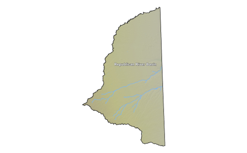
The Republican Basin

Landscape Summaries > Republican Basin Profile

To view mapped wetlands online, click one of the links below.

  • Colorado Wetlands Inventory Mapping Tool
  • National Wetlands Inventory Wetlands Mapper

Wetland Mapping Summary
Area of mapped wetlands 64,676 acres
Percent of basin mapped as wetlands 1%
Wetland Area by Type (acres)
Freshwater Herbaceous41,39564%
Freshwater Shrub 1,0602%
Freshwater Forested 6,46310%
Ponds 9231%
Lakes 1,9253%
Rivers 6,81011%
Other 1,9613%
Wetland Area Mapped with Modifiers (acres)
Excavated 2< 1%
Dammed 0None
Ditched/Drained 0None
Farmed 4,1406%
Modified by Beaver 0None
Wetland Area by Stressor Class (acres)
No Stress24,280< 1%
Low Stress655,32612%
Moderate Stress1,751,69431%
High Stress1,910,38934%
Severe Stress1,284,24923%

Total Area and Elevation Range
Total Area5,625,926 acres 22,768 sq km
Maximum Elevation 5,965 ft1,819 m
Minimum Elevation3,315 ft 1,011 m
Average Elevation4,286 ft 1,307 m

Land Ownership (acres)
Total Federal Lands1,628< 1%
Bureau of Land Management515< 1%
Bureau of Reclamation40< 1%
Federal Land, Misc1,072< 1%
Total Forest Service Land0None
Total State Lands239,0514%
City, County, and Other Local Government Lands3,326< 1%
Land Trusts and Non-Governmental Organizations14,275< 1%
Tribal Lands0None
Private Lands5,367,64695%

Ecoregions (acres)
25: High Plains5,625,191100%
25b: Rolling Sand Plains1,163,59621%
25c: Moderate Relief Plains1,457,76626%
25d: Flat to Rolling Plains3,003,82953%
26: Southwestern Tablelands736< 1%
26e: Piedmont Plains and Tablelands736< 1%

Potential Conservation Areas (PCAs) are delineated around important elements of biodiversity (plants, animals or natural communities). The list below includes all PCAs within the Republican created for wetland and riparian dependent elements. This list represents wetlands and riparian areas with the highest known biodiversity value in the area.

PCA Reports

Click on a Site Name to view PCA Report.

Filter:


(You are viewing 0 of 0 PCA Reports)

Site Name Biodiversity Significance

Tracked elements of biodiversity include animals, plants, and natural communities that are uncommon either globally or within the state of Colorado. The list below includes all wetland and riparian dependent elements found within the Republican and the count of known occurrences.

  • Heritage Network Ranking System

Tracked Elements

Build Your Own Tracking List

Heritage Network Ranking System - Click Here to see the online document that explains the ranking criteria as found in the table below. Last updated xx.

Filters:


The spatial filters below are based on current and historical CNHP element occurrence and observation locations, and not known distributions documented in the literature.


(You are viewing 0 of 0 Elements)

Major Group State Scientific Name Common Name Global Rank State Rank ESA Status CO Status Other Status CNHP Tracking Status

CNHP conducts numerous studies on botany, zoology, ecology, and conservation planning. Many projects are specifically focused on wetland ecosystems and habitats. The list below includes all reports that focus on wetland and riparian areas within the Republican

Reports

Click on a Report Tile to view Report.

Filter:


(You are viewing 0 of 0 reports)

Report Title Authors Year

Wetland Data & Tools

Wetlands Mapper
Floristic Quality Calculator
Landscape Summaries
Watershed Toolbox
Wetland Plots Database

Related Topics

Wetland Reports
PCA Reports
County Survey Reports
Field Guides and App
Field Manuals
Educational Resources
Watershed Toolbox

Web Projects

  • CODEX - Colorado’s Conservation Data Explorer
  • Rare Plant Guide Online
  • Colorado Wetland Info Center
  • COMaP - Colorado Protected Lands
  • Colorado Bat Working Group
  • STReaMS - Endangered Fishes Database
  • Colorado Native Plant Database Data Portal

About Us

  • About Us
  • Conserving Biodiversity
  • Contact Us
  • Staff Directory
  • Careers
  • Site Map
Warner College of Natural Resources Logo
  • Apply to CSU
  • Equal Opportunity
  • Disclaimer
  • Privacy Statement
  • Search CSU
  • CSU Land Acknowledgement
  • CSU Principles of Community
© 2026 Colorado Natural Heritage Program
Colorado State University Logo
  • About
    ▼
    • What Are Wetlands?
    • Why Are Wetlands Important?
    • Colorado Wetland Plan
    • Wetland Partners
  • Wetland Types
    ▼
    • Overview
    • Ecological Systems
    • Natural Plant Communities
    • Fen Mapping
  • Wetland Condition
    ▼
    • Overview
    • Ecological Condition
    • Habitat Quality
    • Biodiversity Significance
    • Colorado Wetland Assessment Projects
    • National Wetland Condition Assessment
    • BLM Assessment Inventory and Monitoring
  • Protection & Conservation
    ▼
    • Overview
    • Conservation
    • Restoration
    • Regulation
    • Best Management Practices
    • Funding and Technical Support
  • Data & Tools
    ▼
    • Wetlands Mapper
    • Floristic Quality Calculator
    • Landscape Summaries
    • Watershed Toolbox
    • Wetland Plots Database
  • Library
    ▼
    • Wetland Reports
    • Potential Conservation Areas
    • County Survey Reports
    • Field Guides and App
    • Field Manuals
    • Educational Resources
  • CNHP Home