Colorado Wetland Information Center Logo Colorado Wetland Information Center Logo CWIC
  • About CWIC
    • What Are Wetlands?
    • Why Are Wetlands Important?
    • Colorado Wetland Plan
    • Wetland Partners
  • Wetland Types
    • Overview
    • Ecological Systems
    • Natural Plant Communities
    • Field Guides and App
    • Fen Mapping
  • Wetland Condition
    • Overview
    • Ecological Condition
    • Habitat Quality
    • Biodiversity Significance
    • Colorado Wetland Assessment Projects
    • National Wetland Condition Assessment
    • BLM Assessment Inventory and Monitoring
  • Working in Wetlands
    • Overview
    • Conservation
    • Restoration
    • Regulation
    • Best Management Practices
    • Funding and Technical Support
  • Data & Tools
    • Wetlands Mapper
    • Floristic Quality Calculator
    • Landscape Summaries
    • Watershed Toolbox
    • Wetland Plots Database
  • Library
    • Wetland Reports
    • Potential Conservation Areas
    • County Survey Reports
    • Field Guides and App
    • Field Manuals
    • Educational Resources
  • CNHP Home

Overview of Wetland Condition

Wetlands provide many important benefits to the people of Colorado through the ecological functions they perform. Wetlands in good condition are better able to provide those benefits than wetlands that have been heavily impacted. Assessment and monitoring programs are essential for measuring the quality of wetland health and the level of functions they perform. Wetland assessment projects provide baseline information on the ecological condition, habitat quality, or biological significance of wetlands in order to inform management decisions and help target restoration or conservation projects. Long-term monitoring, in which sites are visited multiple times over several years, can reveal changes in wetland condition over time.

Wetland complex containing beaver ponds and fens, San Juan Mountains, CO. Joanna Lemly, CNHP.

Level 1-2-3 Framework for Wetland Assessment

Because it is impossible to visit every wetland to determine its condition, the U.S. Environmental Protection Agency (EPA) recommends a three-tiered approach to wetland assessment. The Level 1-2-3 framework for wetland assessment and monitoring is a hierarchical approach that involves increasing degrees of effort and cost with each increasing level of assessment.

  • Level 1 (landscape assessment) relies on coarse, landscape scale inventory information, typically gathered through remote sensing and preferably stored in, or convertible to, a geographic information system (GIS) format.
  • Level 2 (rapid assessment) is at the specific wetland site scale, using relatively simple, rapid protocols.
  • Level 3 (intensive site assessment) uses intensive research-derived, multi-metric indices of biological integrity. Nearly all assessment methods in use today fit within one or more levels of this paradigm.
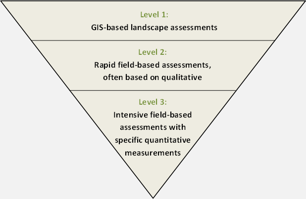
EPA's Level 1-2-3 Framework for Wetland Assessment.

Wetland Condition Assessment Methods and Projects

Back to top

CNHP Field Ecologist assess wetland vegetation in the North Platte River Basin. CNHP Staff.

Ecological Condition Assessment Methods

CHNP has developed ecological condition assessment methods for all three levels within the Level 1-2-3 Framework. In addition to protocols developed by CNHP, several wetland and riparian assessment protocols are used by various Colorado agencies and partners.

Visit the Assessment Methods Page

Learn more

Long-billed Curlew - Laguna Atoscosa NWR, Texas. Brian Tang.

Habitat Quality Assessment Methods

Wildlife habitat is among the most critical functions wetlands provide. CNHP and parnters have developed factsheet and habitat scorecards to help landowners and land managers understanding habitat needs of priority wetland-dependent wildlife.

Visit the National Wetland Condition Assessment Page

Learn more

Fen wetlands in Boulder County. Joanna Lemly.

Biodiversity Significance

Wetlands are among the most diverse ecosystems in Colorado. Since 1992, CNHP has partnered with public, non-profit, and private entities to conduct surveys of critical biological resources for counties and/or watersheds.

Visit the National Wetland Condition Assessment Page

Learn more

Overlooking a large playa wetland in the San Luis Valley. CNHP Staff.

Colorado Wetland Assessment Projects

In 2008, CNHP began a series of field projects to assess the condition of wetlands in Colorado’s major river basins. Our goal is to survey each of the major river basins on a rotating schedule every 10 to 15 years.

Visit the Basinwide Assessments Page

Learn more

Sampling a wetland soil pit for the NWCA. CNHP Staff.

National Wetland Condition Assessment

The National Wetland Condition Assessment (NWCA) is a collaborative survey of the nation's wetlands. CNHP is an active participant of the NWCA and coordinated sampling in Colorado for both the 2011 and 2016 surveys.

Visit the National Wetland Condition Assessment Page

Learn more

Wetland Condition

Overview
Ecological Condition
Habitat Quality
Biodiversity Significance
Colorado Wetland Assessment Projects
National Wetland Condition Assessment

Related Topics

Wetland Reports
PCA Reports
County Survey Reports
Field Guides and App
Field Manuals
Educational Resources
Watershed Toolbox

Web Projects

  • CODEX - Colorado’s Conservation Data Explorer
  • Rare Plant Guide Online
  • Colorado Wetland Info Center
  • COMaP - Colorado Protected Lands
  • Colorado Bat Working Group
  • STReaMS - Endangered Fishes Database
  • Colorado Native Plant Database Data Portal

About Us

  • About Us
  • Conserving Biodiversity
  • Contact Us
  • Staff Directory
  • Careers
  • Site Map
Warner College of Natural Resources Logo
  • Apply to CSU
  • Equal Opportunity
  • Disclaimer
  • Privacy Statement
  • Search CSU
  • CSU Land Acknowledgement
  • CSU Principles of Community
© 2025 Colorado Natural Heritage Program
Colorado State University Logo
  • About CWIC
    ▼
    • What Are Wetlands?
    • Why Are Wetlands Important?
    • Colorado Wetland Plan
    • Wetland Partners
  • Wetland Types
    ▼
    • Overview
    • Ecological Systems
    • Natural Plant Communities
    • Field Guides and App
    • Fen Mapping
  • Wetland Condition
    ▼
    • Overview
    • Ecological Condition
    • Habitat Quality
    • Biodiversity Significance
    • Colorado Wetland Assessment Projects
    • National Wetland Condition Assessment
    • BLM Assessment Inventory and Monitoring
  • Working in Wetlands
    ▼
    • Overview
    • Conservation
    • Restoration
    • Regulation
    • Best Management Practices
    • Funding and Technical Support
  • Data & Tools
    ▼
    • Wetlands Mapper
    • Floristic Quality Calculator
    • Landscape Summaries
    • Watershed Toolbox
    • Wetland Plots Database
  • Library
    ▼
    • Wetland Reports
    • Potential Conservation Areas
    • County Survey Reports
    • Field Guides and App
    • Field Manuals
    • Educational Resources
  • CNHP Home