Colorado Wetland Information Center Logo Colorado Wetland Information Center Logo CWIC
  • About
    • What Are Wetlands?
    • Why Are Wetlands Important?
    • Colorado Wetland Plan
    • Wetland Partners
  • Wetland Types
    • Overview
    • Ecological Systems
    • Natural Plant Communities
    • Fen Mapping
  • Wetland Condition
    • Overview
    • Ecological Condition
    • Habitat Quality
    • Biodiversity Significance
    • Colorado Wetland Assessment Projects
    • National Wetland Condition Assessment
    • BLM Assessment Inventory and Monitoring
  • Protection & Conservation
    • Overview
    • Conservation
    • Restoration
    • Regulation
    • Best Management Practices
    • Funding and Technical Support
  • Data & Tools
    • Wetlands Mapper
    • Floristic Quality Calculator
    • Landscape Summaries
    • Watershed Toolbox
    • Wetland Plots Database
  • Library
    • Wetland Reports
    • Potential Conservation Areas
    • County Survey Reports
    • Field Guides and App
    • Field Manuals
    • Educational Resources
  • CNHP Home

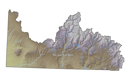
The Upper San Juan Basin

Landscape Summaries > Upper San Juan Basin Profile

To view mapped wetlands online, click one of the links below.

  • Colorado Wetlands Inventory Mapping Tool
  • National Wetlands Inventory Wetlands Mapper

Wetland Mapping Summary
Area of mapped wetlands 66,189 acres
Percent of basin mapped as wetlands 2%
Wetland Area by Type (acres)
Freshwater Herbaceous32,77650%
Freshwater Shrub 4,8037%
Freshwater Forested 99< 1%
Ponds 13,57321%
Lakes 9,58414%
Rivers 4,8657%
Other 4901%
Wetland Area Mapped with Modifiers (acres)
Excavated 2,4354%
Dammed 12,91020%
Ditched/Drained 1< 1%
Farmed 0None
Modified by Beaver 1,2022%
Wetland Area by Stressor Class (acres)
No Stress524,17414%
Low Stress1,270,98734%
Moderate Stress626,80517%
High Stress575,37816%
Severe Stress713,63819%

Total Area and Elevation Range
Total Area3,710,984 acres 15,018 sq km
Maximum Elevation 14,150 ft4,314 m
Minimum Elevation4,595 ft 1,401 m
Average Elevation7,928 ft 2,417 m

Land Ownership (acres)
Total Federal Lands1,665,77345%
Bureau of Land Management288,9878%
National Park Service54,1071%
Total Forest Service Land1,322,67836%
Grand Mesa, Uncompahgre, and Gunnison National Forests145< 1%
Rio Grande National Forest1,683< 1%
San Juan National Forest1,320,85036%
Total State Lands37,1781%
City, County, and Other Local Government Lands939< 1%
Land Trusts and Non-Governmental Organizations0None
Tribal Lands770,20421%
Private Lands1,236,89033%

Ecoregions (acres)
20: Colorado Plateaus1,706,11046%
20a: Monticello-Cortez Uplands575,90616%
20b: Shale Deserts and Sedimentary Basins189,2275%
20c: Semiarid Benchlands and Canyonlands904,09724%
20d: Arid Canyonlands36,8801%
21: Southern Rockies2,004,87454%
21a: Alpine Zone281,1028%
21b: Crystalline Subalpine Forests140,9784%
21c: Crystalline Mid-Elevation Forests26,3621%
21d: Foothill Shrublands17,699< 1%
21e: Sedimentary Subalpine Forests403,02511%
21f: Sedimentary Mid-Elevation Forests892,18124%
21g: Volcanic Subalpine Forests243,5267%

Potential Conservation Areas (PCAs) are delineated around important elements of biodiversity (plants, animals or natural communities). The list below includes all PCAs within the Upper San Juan created for wetland and riparian dependent elements. This list represents wetlands and riparian areas with the highest known biodiversity value in the area.

PCA Reports

Click on a Site Name to view PCA Report.

Filter:


(You are viewing 0 of 0 PCA Reports)

Site Name Biodiversity Significance

Tracked elements of biodiversity include animals, plants, and natural communities that are uncommon either globally or within the state of Colorado. The list below includes all wetland and riparian dependent elements found within the Upper San Juan and the count of known occurrences.

  • Heritage Network Ranking System

Tracked Elements

Build Your Own Tracking List

Heritage Network Ranking System - Click Here to see the online document that explains the ranking criteria as found in the table below. Last updated xx.

Filters:


The spatial filters below are based on current and historical CNHP element occurrence and observation locations, and not known distributions documented in the literature.


(You are viewing 0 of 0 Elements)

Major Group State Scientific Name Common Name Global Rank State Rank ESA Status CO Status Other Status CNHP Tracking Status

CNHP conducts numerous studies on botany, zoology, ecology, and conservation planning. Many projects are specifically focused on wetland ecosystems and habitats. The list below includes all reports that focus on wetland and riparian areas within the Upper San Juan

Reports

Click on a Report Tile to view Report.

Filter:


(You are viewing 0 of 0 reports)

Report Title Authors Year

Wetland Data & Tools

Wetlands Mapper
Floristic Quality Calculator
Landscape Summaries
Watershed Toolbox
Wetland Plots Database

Related Topics

Wetland Reports
PCA Reports
County Survey Reports
Field Guides and App
Field Manuals
Educational Resources
Watershed Toolbox

Web Projects

  • CODEX - Colorado’s Conservation Data Explorer
  • Rare Plant Guide Online
  • Colorado Wetland Info Center
  • COMaP - Colorado Protected Lands
  • Colorado Bat Working Group
  • STReaMS - Endangered Fishes Database
  • Colorado Native Plant Database Data Portal

About Us

  • About Us
  • Conserving Biodiversity
  • Contact Us
  • Staff Directory
  • Careers
  • Site Map
Warner College of Natural Resources Logo
  • Apply to CSU
  • Equal Opportunity
  • Disclaimer
  • Privacy Statement
  • Search CSU
  • CSU Land Acknowledgement
  • CSU Principles of Community
© 2026 Colorado Natural Heritage Program
Colorado State University Logo
  • About
    ▼
    • What Are Wetlands?
    • Why Are Wetlands Important?
    • Colorado Wetland Plan
    • Wetland Partners
  • Wetland Types
    ▼
    • Overview
    • Ecological Systems
    • Natural Plant Communities
    • Fen Mapping
  • Wetland Condition
    ▼
    • Overview
    • Ecological Condition
    • Habitat Quality
    • Biodiversity Significance
    • Colorado Wetland Assessment Projects
    • National Wetland Condition Assessment
    • BLM Assessment Inventory and Monitoring
  • Protection & Conservation
    ▼
    • Overview
    • Conservation
    • Restoration
    • Regulation
    • Best Management Practices
    • Funding and Technical Support
  • Data & Tools
    ▼
    • Wetlands Mapper
    • Floristic Quality Calculator
    • Landscape Summaries
    • Watershed Toolbox
    • Wetland Plots Database
  • Library
    ▼
    • Wetland Reports
    • Potential Conservation Areas
    • County Survey Reports
    • Field Guides and App
    • Field Manuals
    • Educational Resources
  • CNHP Home