Ecological condition assessment methods measure overall wetland condition with an emphasis on ecological integrity or the ability of an ecosystem to support and maintain the species composition, diversity, and function comparable to similar systems in an undisturbed state. CHNP has developed protocols for assessing and monitoring ecological condition at all three levels within the Level 1-2-3 Framework. In particular, we have used the Ecological Integrity Assessment (EIA) and Floristic Quality Assessment methods to assess the condition of Colorado's wetlands through a series of wetland assessment projects. All methods listed here have been developed with funding from U.S. Environmental Protection Agency Region 8 and Colorado Parks and Wildlife. In addition to protocols developed by CNHP, several other wetland and riparian protocols are used by various Colorado agencies and partners.
Click a link below for details.

Digital National Wetland Inventory (NWI) mapping provides the most basic Level 1 assessment by quantifying the acres, types, and distribution of wetlands across a given landscape. This information is often the foundation of more intensive assessment, including serving as the sample frame needed to randomly select wetlands for the field-based Level 2 and 3 assessments. For more information, see the interactive Wetlands Mapper or see the Landscape Summaries for an accounting of wetland acres by river basin, subbasin, and county.
Landscape Integrity Model (LIM) for Wetlands is a statewide Level 1 GIS-based model of threats and stressors that affect wetland health. The model was built using available GIS data for specific anthropogenic stressors that affect wetlands. The impact of each stressor was weighted and scored based on best professional judgment of the stressor’s relative importance. Individual scores were then combined to create a cumulative, continuous surface of relative impact. High values equate to high stress and low landscape integrity while low scores equate to low stress and high landscape integrity. From more information, see Section 2.2 of the report Statewide Strategies for Wetlands.

Ecological Integrity Assessment (EIA) framework forms the basis of CNHP’s Level 2 Rapid Assessment protocol. The EIA Framework was developed by NatureServe and ecologist from several Natural Heritage Programs across the country. Colorado-specific EIA protocols have been developed and refined by CNHP with funding from EPA Region 8 and Colorado Parks and Wildlife. The EIA method is an ecologically based condition assessment method that focuses on the biological response to disturbance but also evaluates underlying processes.
The EIA framework evaluates wetland condition using on a multi-metric index based on three major factors. Each factor has associated metrics, which are scored based on quantitative or qualitative criteria.
- Landscape Context (landscape, buffer)
- Condition (vegetation, hydrology, soil, water quality)
- Size
The EIA method has been used in a series of wetland assessment projects to evaluate wetland condition in several major Colorado river basins.
Download the EIA field manual and associated data sheets.
Read background reports on the Ecological Integrity Assessment (EIA) Framework

Floristic Quality Assessment (FQA) is a vegetation-based assessment tool that evaluates an area’s ecological integrity based on its plant species composition. The method is built on the concept of species conservatism, which refers to a species’ tolerance or intolerance to disturbance. The FQA method uses “coefficients of conservatism” or “C-values” assigned to all species in a region or state. C-values range from 0 to 10 and represent an estimated probability that a plant is likely to occur in a landscape relatively unaltered from pre-European settlement conditions (see table below). High C-values are assigned to species that are obligate to high-quality natural areas and cannot tolerate habitat degradation, while low C-values are assigned to species with wide tolerance to human disturbance. C-values of 0 are reserved for non-native species.
| C-Values | Interpretation |
| 0 | Non-native species. Very prevalent in new ground or non-natural areas. |
| 1-3 | Commonly found in non-natural areas. |
| 4-6 | Equally found in natural and non-natural areas. |
| 7-9 | Obligate to natural areas but can sustain some habitat degradation. |
| 10 | Obligate to high-quality natural areas (relatively unaltered from pre-European settlement). |
The proportion of conservative plants in a community provides a powerful and relatively easy assessment of a site’s ecological integrity that moves beyond simple measures of species richness and abundance. Several numeric indices can be calculated from a site species list and associated C-values. The most basic FQA index is a simple average of C-values for a given site, called the Mean C. More complex indices can be calculated by incorporating species richness, using only native species, or weighting by abundance. The most common indices include:

- Total Mean C: Mean coefficient of conservatism value of all species present.
- Native Mean C: Mean coefficient of conservatism value of native species present. If total and native mean C differ significantly, vegetation in the site contains numerous non-native species.
- Floristic Quality Index (FQI): Incorporates species richness and indicates overall vegetative quality of the site. Generally, 1–19 is low quality, 20–35 is high quality, and above 35 is exceptional.
How to use the Floristic Quality Assessment
Anyone can use the FQA method. The method is more commonly used in wetland environments, but it is equally applicable across all ecosystems. C-values for Colorado species were assigned by a panel of botanical experts in 2006 and updated in 2020. CNHP has developed an FQA Calculator that can be used to calculate FQA indices from any plant list. See links below to read the FQA reports, download the Colorado FQA database, or use the Colorado FQA Calculator. The Colorado FQA database is also available on the Universal FQA Calculator, an open-source web tool that includes FQA databases from across the United States.
Read the Colorado FQA Reports and access the Colorado FQA Database
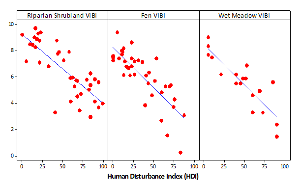
Vegetation Index of Biotic Integrity (VIBI). Biotic integrity is defined as the ability of an ecosystem to "support and maintain a balanced adaptive community of organisms having a species composition, diversity, and functional organization comparable to that of natural habitats within a region." An index of biotic integrity (IBI) is a cost-effective and direct way to evaluate the biotic integrity of a wetland by measuring attributes of the biological community known to respond to human disturbance.
CNHP developed vegetation indices of biotic integrity (VIBI) for three selected headwater wetland types within the Southern Rocky Mountains of Colorado:
- Subalpine-Montane Riparian Shrublands
- Subalpine-Montane Fens
- Alpine-Montane Wet Meadows
Colorado’s VIBIs are a valuable tool that can be used by land managers to monitor and evaluate: (1) the performance of wetland restoration, enhancement, and creation projects; (2) the success of preserving ecological integrity via wetland protection projects; and (3) the effectiveness of on-going management practices.

Read the Vegetation Index of Biotic Integrity (VIBI) Reports
Besides the methods developed by CNHP, additional assessment methods are frequently used in Colorado by specific agencies or for specific purposes.
Functional Assessment of Colorado Wetlands (FACWet) was developed by Dr. Brad Johnson with funding from the Colorado Department of Transportation. FACWet is a functionally based condition assessment method that focuses on physical drivers of wetland processes in an effort to highlight the causes of degradation. The FACWet method has been endorsed by the U.S. Army Corps of Engineers (ACOE) and is now required to accompany all Section 404 permits for wetland impacts or mitigation plans.
From a comparison of the EIA and FACWet methods, see Section 5.0 of the report Setting Mitigation in the Watershed Context.

The U.S. Environmental Protection Agency's National Aquatic Resource Survey (NARS) Program has developed rigorous quantitative assessment methods for wetlands, lakes, and rivers and streams. The NARS Program surveys the health of the nation's waters on a rotating five-year cycle, focusing on one resource type at a time. CNHP has been very involved in the National Wetland Condition Assessment, which has taken place three times in 2011, 2016, and 2021.
The Bureau of Land Management has developed three methods for assessing the physical functioning of riparian and wetland areas.
- Assessment Inventory and Monitoring (AIM) is a standardized monitoring program for BLM public lands. CNHP works closely with the BLM to monitor wetlands, riparian areas, and streams in multiple western states through the AIM program.
- Proper Functioning Condition (PFC) is a qualitative rapid assessment method often carried out by a multi-disciplinary team. The term PFC is used to describe both the assessment process and a defined, on-the-ground condition of a riparian-wetland area. There are two technical references for PFC, one for stream channels and one for vegetated wetlands.
- Multiple Indicator Monitoring (MIM) of Stream Channels and Streamside Vegetation is a more quantitative rapid assessment method that monitors both short-term, livestock grazing use indicators as well as long-term indicators of resource condition.


The U.S. Forest Service's National Stream & Aquatic Ecology Center has developed a core monitoring protocol for riparian areas on National Forests. The purpose of the National Riparian Protocol (NRPC) is to provide guidance on sampling riparian vegetation and physical characteristics along wadeable stream channels and their associated floodplains and valley bottoms. This NRCP is a basic protocol designed for sampling ecologically important characteristics of riparian areas at the reach scale, including: (1) species composition, (2) vertical structure of vegetation, (3) size-class structure of trees, and (4) physical channel characteristics.
The National Park Service's Rocky Mountain Inventory & Monitoring Network has developed Wetland Ecological Integrity monitoring protocols for use in all National Park units within the network, including Rocky Mountain NP, Great Sand Dunes NP, and Glacier NP. Objective's of the NPS wetland monitoring program include determining long-term status and trend in the spatial extent of wetland by key type within each park and monitoring the status and trend in vegetation assemblages at the park scale using multimetric indices. CNHP has been working with NPS to monitoring wetlands in Great Sand Dunes NP since 2016 to inform the Park's future ungulate management plan.


