


Rocky Mountain Subalpine-Montane Fen
Click link below for details.
General Description
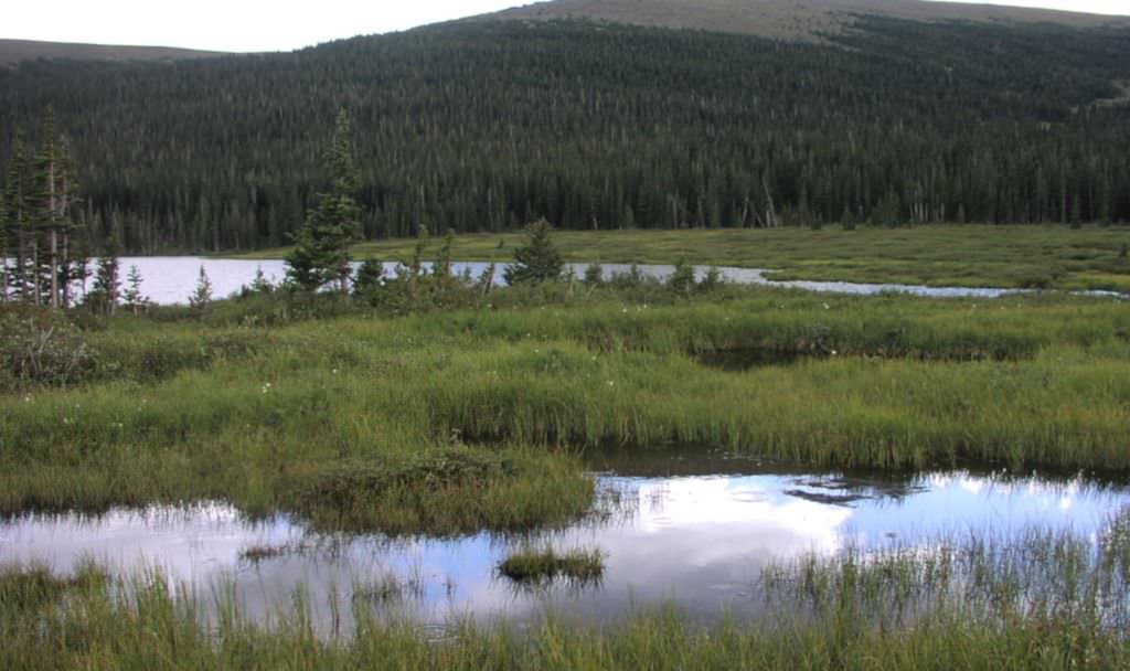
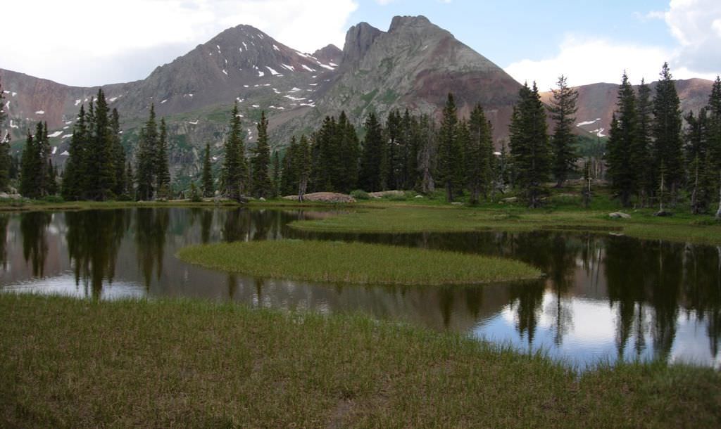
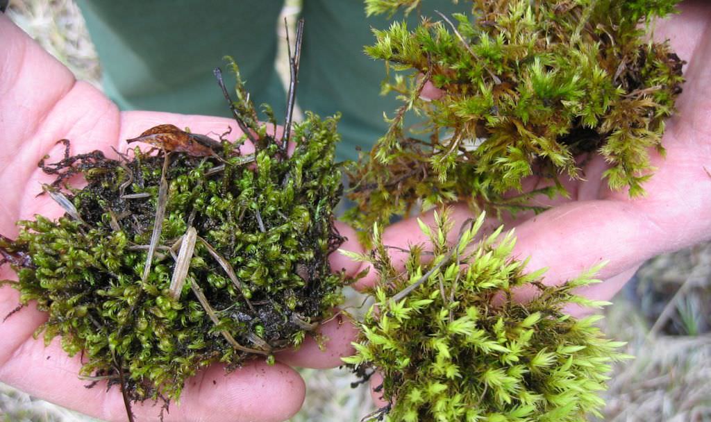
Rocky Mountain Subalpine-Montane Fens are groundwater-fed, peat-accumulating wetlands with perennially saturated soils. This system is confined to specific environments where groundwater discharge is sufficient to generate peat (organic soil) accumulation of at least 40 cm. Fens form in natural depressions (basin fens) or at the base of slopes where groundwater intercepts the soil surface (slope fens). Fens are often classified by water chemistry and floristic composition into the categories of rich fens, intermediate fens, and poor fens, though Colorado's uncommon iron fens fall outside of the typical classification. Fens often occur as a mosaic of several plant associations and can support numerous rare species and community types. The most common dominants include water sedge (Carex aquatilis) and beaked sedge (C. utriculata), often accompanied by a diversity of other sedge species (Carex illota, C. limosa, C. simulata, C. buxbaumii and others) as well as spikerushes (Eleocharis spp.), bog sedges (Kobresia spp.), cottongrasses (Eriophorum spp.), and rushes (Juncus spp.). Common forbs include elephanthead lousewort (Pedicularis groenlandica), redpod stonecrop (Rhodiola rhodantha), marsh marigold (Caltha leptosepala), and felwort (Swertia perennis). Sites can contain a woody component dominated by shrubs (Salix spp. and Betula glandulosa) or coniferous trees (Picea engelmannii or Pinus contorta). Bryophyte diversity is generally high and includes brown mosses and sphagnum (Sphagnum spp.).
Diagnostic Characteristics
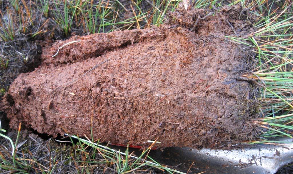
Fens are characterized by at least 40 cm of peat (organic soil) and by perennial saturation maintained primarily by groundwater.
Similar Systems
North American Arid West Emergent Marsh: Marshes lack deep organic soils and, unlike fens or wet meadows, experience deep inundation.
Range
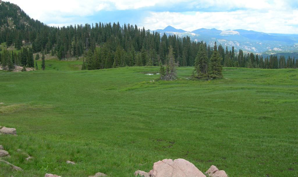
This system occurs infrequently throughout the Rocky Mountains from Colorado north into Canada. The vast majority of Colorado fens are found between 9,000-12,000 ft (2750-3350 m) in the upper montane to subalpine zone. However, small to medium fens can be found at lower elevations, including scattered locations in the plains where springs discharge sufficient groundwater. The map below was generated from several fen mapping projects, mostly on National Forest lands; however, the mapping data are not comprehensive across the state and there are undoubtedly fens in areas not shown on this map.
Ecological System Distribution

Spatial Pattern
Colorado fens are a small patch ecological systems.
Environment
Fens are confined to specific environments where groundwater discharge is sufficient to support the development of at least 40 cm of peat (organic soil). In these sites, groundwater inflows create constant the high water levels and perennially saturated soils that enable the development of deep peat soils. The lack of oxygen in saturated soils causes organic matter to accumulate faster than it can be broken down. Over thousands of years, fens can develop organic layers up to two meters or more in depth.
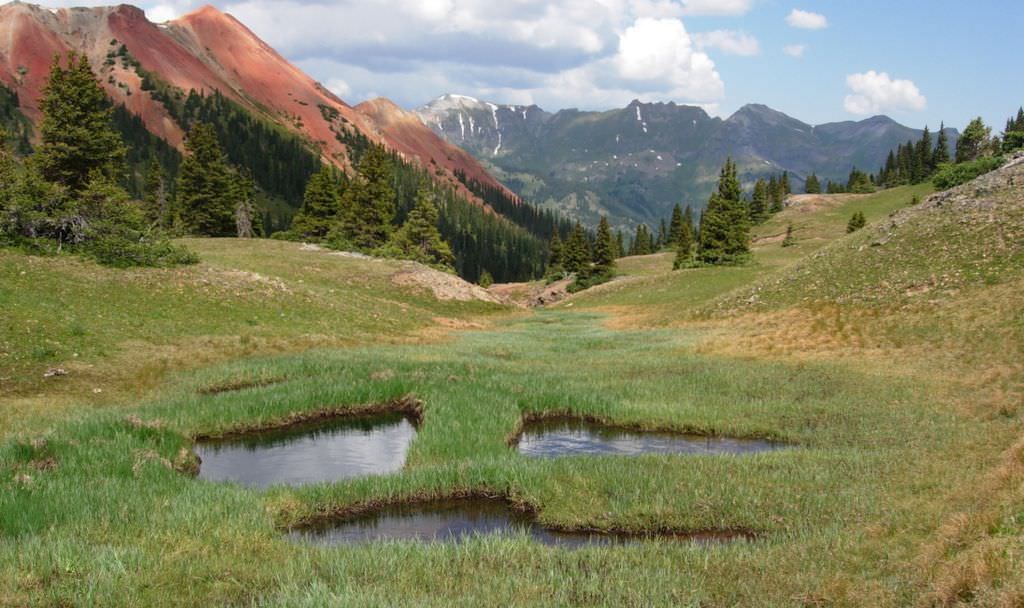
The interaction of climate and geomorphology has a strong influence on local hydrological processes that shape fens. Generally, fens form either at low points in the landscape (basin fens) or near slopes where groundwater intercepts the soil surface (slope fens). In the high elevation mountains of Colorado, glaciers sculpted much of the landscape, creating wide level mountain valleys, moraines and kettle ponds that are conducive for fen formation. Fens often form in valleys due to large alluvial aquifers and nearby springs supplied by snowmelt from adjacent hillsides. Terminal or lateral moraines often create confined basins where impounded subsurface and/or surface water allows for peat accumulation, whereas kettle ponds create a permanent water body around which fens can form.
Climate influences the snowpack and timing of melt, which contributes a large proportion of water to fen wetlands through its influence on groundwater and surface water dynamics. Colorado's continental climate, with warm dry summers and cold winters, produces an overall semi-arid environment. Colorado's fens are generally restricted to high mountain valleys where cool temperatures, low evapotranspiration rates, and high precipitation create conditions amenable to peat formation. Based on several fen mapping efforts across the state, approximately 90% of Colorado's fens occur between 9,000-12,000 ft (2750-3350 m) elevation. At these high elevations, most precipitation occurs as snowfall during the winter months (as much as 80%). In many fens, snowmelt maintains sufficiently high water tables through June. However, only those areas with soil saturation or a water table within 30 cm of the soil surface through July and August accumulates peat. Late summer precipitation also contributes to fen maintenance by replenishing local aquifers and rising water tables.
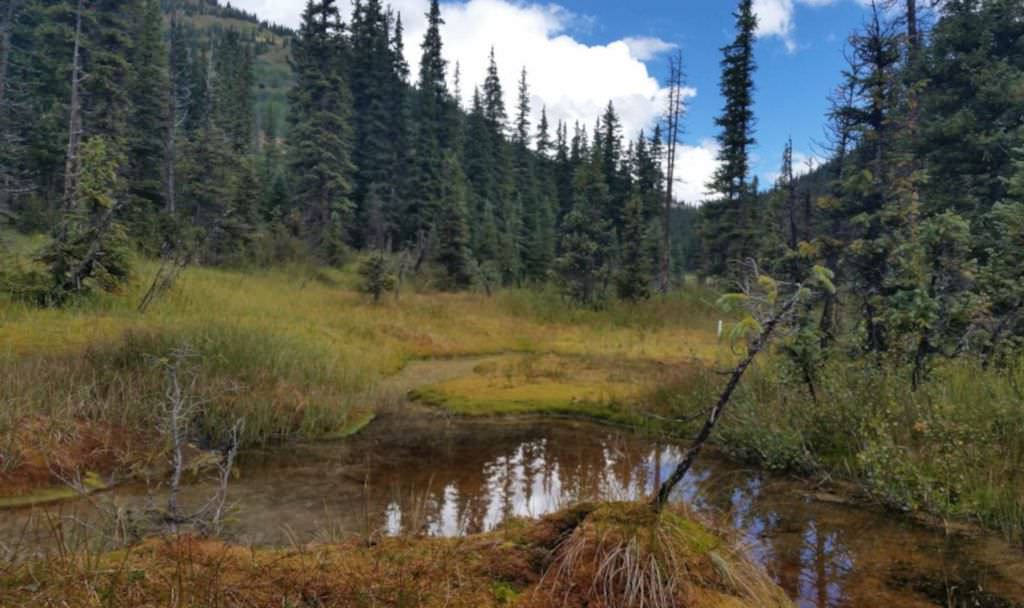
Soil and water chemistry are among the most important factors structuring fen ecosystems. Southern Rocky Mountain fens receive much of their nutrients and salts (ions) from surface and groundwater inputs; groundwater picks up nutrients as it percolates through soils and bedrock in the contributing watershed. Thus fens can be classified according to water chemistry along a chemical gradient from poor fens with low pH and ionic concentrations to rich and extreme rich fens with high pH and ionic concentrations. There are three common types of Rocky Mountain fens by water chemistry. Intermediate to rich fens (pH ~5.0-6.5) are generally associated with granitic bedrock and occur throughout Colorado's mountains. Extreme rich fens (pH >~6.5 or 7.0) are found primarily in the open valley of South Park in Park County, Colorado, and are associated with calcareous bedrock. Iron fens (pH as low as 3.0) are found in the San Juan Mountains in southwestern Colorado associated with geologic sources of acid produced from water passing through highly mineralized outcrops of iron pyrite, which oxidizes to form sulfuric acid. Iron fens are outside the typical water chemistry classification becasue they have both low pH, but very high ionic concentrations.
Vegetation
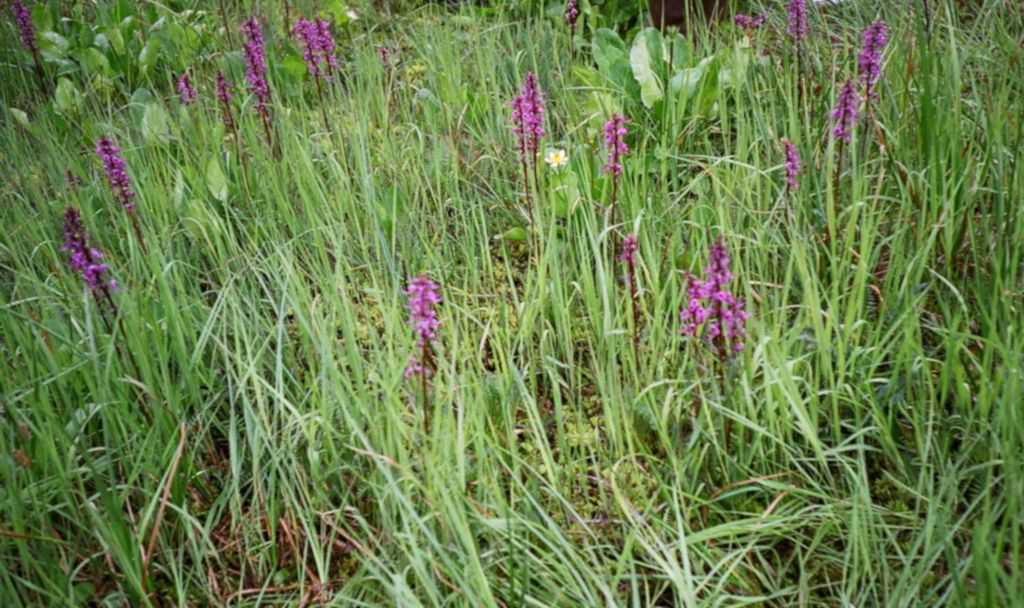
Fen vegetation is quite diverse, both within and between fens. Species composition across fens is influenced by water chemistry (described in the preceding section), landscape position, and elevation. Within individual fens, vegetation often occurs as a mosaic of several plant associations, influenced by slope and water table depth.
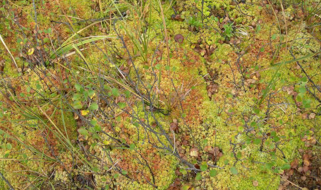
Intermediate to rich fens are often dominated by graminoids, especially clonal sedges such as water sedge (Carex aquatilis) and beaked sedge (C. utriculata), although a wide variety of other sedges also may occur such as woollyfruit sedge (C. lasiocarpa), Buxbaum's sedge (C. buxbaumii) and small-winged sedge (C. simulata). Forbs are often present, but not dominant. Common forb species include include elephanthead lousewort (Pedicularis groenlandica), marsh marigold (Caltha leptosepala), large leaf avens (Geum macrophyllum), American speedwell (Veronica americana), fringed grass of Parnassus (Parnassia fimbriata), and alpine meadow-rue (Thalictrum alpinum). Low stature shrubs such as bog birch (Betula glandulosa), planeleaf (Salix planifolia) and Wolf willow (S. wolfii) are also commonly found in these fens. Mosses are an integral floristic as well as functional component to fens. Mosses provide a critical role in the accumulation of peat, formation of hummocks, and nutrient cycling. Most fens in the Southern Rocky Mountains are dominated by brown mosses, including Aulacomnium palustre, Tomentypnum nitens, and Drepanocladus spp. Sphagnum mosses (Sphagnum spp.) are not as common as brown mosses in intermediate and rich fens; however Sphagnum is an important and conspicuous component of iron fens
The extreme rich fens found in Park County, Colorado, are dominated by simple bog sedge (Kobresia simpliciuscula), Bellardi's bog sedge (Kobresia myosuroides), few-flowered spikerush, and arrowgrass (Triglochin spp.). The unusual water chemistry of extreme rich fens supports many rare plants such as Porter's feathergrass (Ptilagrostis mongholica ssp. porteri) and pale blue-eyed grass (Sisyrinchium pallidum). These fens also support several rare aquatic and semi-aquatic macroinvertebrates including aquatic beetles, a caddisfly (Ochrotrichia susanae) known from only one other location in the world and a glass snail (Physa skinneri).
Iron fens can support an open tree canopy of Engelmann spruce (Picea engelmannii) and lodgepole pine (Pinus contorta), as well as shrubs including bog birch, dwarf blueberry (Vaccinium cespitosum), and creeping wintergreen (Gaultheria humifusa). Water sedge and bluejoint reedgrass (Calamagrostis canadensis) occur over a continuous carpet of mosses mainly dominated by species of Sphagnum. At the Mount Emmons Iron Fen in Gunnison County, CO, two unusual species of dragonfly (Leucorhinea hudsonica and Sematochlora semicircularis) are associated with the fen.
Basin fens, which have floating mats support rare wetland plants in the Southern Rocky Mountains, such as roundleaf sundew (Drosera rotundifolia), bog bean (Menyanthes trifoliata), marsh cinquefoil (Comarum palustre), and numerous uncommon sedges (Carex buxbaumii, C. limosa, C. dioica, etc.). Because these floating mats are often nutrient poor, many species of Sphagnum also occur in these areas.
- CEGL002899 Betula glandulosa / Sphagnum spp. Shrub Fen
- CEGL002898 Carex aquatilis - Sphagnum spp. Fen
- CEGL001806 Carex buxbaumii Fen
- CEGL002549 Carex diandra Wet Meadow Fen
- CEGL001810 Carex lasiocarpa Fen
- CEGL001811 Carex limosa Fen
- CEGL001823 Carex scopulorum - Caltha leptosepala Wet Meadow
- CEGL001825 Carex simulata Fen
- CEGL002922 Carex utriculata Perched Wetland Fen
- CEGL001562 Carex utriculata Wet Meadow
- CEGL001836 Eleocharis quinqueflora Fen
- CEGL005661 Glaux maritima - Poa secunda Rich Fen
- CEGL002900 Kobresia myosuroides - Thalictrum alpinum Fen
- CEGL002901 Kobresia simpliciuscula - Trichophorum pumilum Fen
- CEGL003410 Menyanthes trifoliata Aquatic Vegetation
Associated Animal Species
Fens provide critical habitat for amphibians and invertebrates. Subalpine fens in central Colorado are known to support the rare Rocky Mountain populations of the boreal toad (Anaxyrus boreas boreas). Extreme rich fens of Park County support several rare aquatic and semi-aquatic macroinvertebrates including aquatic beetles, a caddisfly (Ochrotrichia susanae) known from only one other location in the world and a glass snail (Physa skinneri).
Dynamic Processes
Fens form where the rate of plant growth exceeds the rate of litter decomposition. Thus, in the semi-arid Southern Rocky Mountains fens develop where saturated soils and cool temperatures slow decomposition, resulting in the accumulation of peat. Most Colorado fens began to develop following the last retreat of the glaciers, approximately 10,000 years ago. Colorado fens develop successionally generally through lake-filling or by flow-through succession. Lake filling can create basin fens, which are found in confined basins that have often been created by the impoundment of subsurface (upwelling groundwater) and/or surface flow by terminal or lateral moraines or in wide, glacially carved valleys where there is typically no inlet or outlet. These fens are often characterized by the presence of floating mats and a ring of carr vegetation on the outer margin of the peatland. Flow-through succession creates slope fens which develop where a constant a constant inflow and outflow of water occurs along streams, slopes, benches and valley bottoms. Slope fens occur where groundwater discharges due to a beak in topography or a change in geology, or in valley bottoms where alluvial groundwater supports peat formation. In the Southern Rocky Mountains, fens generally do not succeed to upland forests but rather maintain a peatland climax due to dynamic processes associated with the oxidation and accumulation of peat in relation to fluctuating climatic conditions.
Management
Because groundwater provides the main water source for fens and fens are very sensitive to changes in groundwater supply. Fens are altered by on-site or off-site impacts. On-site impacts include filling, hydrologic alteration such as by drainage ditches that dewaters a fen, snow compaction such as occurs by ski runs or snowmobiles, trampling such as may occur by livestock or humans, and mining. Off-site impacts include upland habitat development that indirectly alters fen condition by altering hydrology, sediment and water chemistry inputs such as may occur with ski area development or logging; and direct hydrologic alteration that may occur with development activities such as water diversions and groundwater pumping. In Colorado, global climate change is resulting in increased temperatures, which is driving declines in the spring snowpack, earlier snowmelt and increased fraction of winter precipitation falling as rain. The sensitivity of fens to environmental change likely varies, with individual responses depending on both peatland type and the relative stability of hydrological conditions supporting peat accumulation.
References
- Bauer, I.E., L.D. Gignac, and D.H. Vitt. 2003. Development of a peatland complex in boreal western Canada: lateral site expansion and local variability in vegetation succession and long-term peat accumulation. Canadian Journal of Botany 81:833-847.
- Chimner, R.A., J.M. Lemly, and D.J. Cooper. 2010. Mountain fen distribution, types, and restoration priorities, San Juan Mountains, Colorado, USA. Wetlands, 30: 763771.
- Colorado Natural Areas Program, Colorado State Parks, and Colorado Department of Natural Resources. 1998. Native Plant Revegetation Guide for Colorado. Caring for the Land Series III
- Cooper, D.J. 1990. Ecology of wetlands in Big Meadows, Rocky Mountain National Park, Colorado. Biological report 90(15). Unpublished report prepared for the US Fish and Wildlife Service, Denver, CO.
- Cooper, D. J. 1990. Ecological Studies of Wetlands in South Park, Colorado: Classification, Functional Analysis, Rare Species Inventory, and the Effects of Removing Irrigation. Report prepared for: Park County and U.S. EPA Region VIII. Boulder Co. 94pp.
- Cooper, D.J. 1996. Water and soil chemistry, floristics, and phytosociology of the extreme rich High Creek fen, in South Park, Colorado, U.S.A.
- Cooper, D.J. 2005. Analysis of the Strawberry Lake fen complex, Arapaho National Forest, Colorado.
- Cooper, D.J. and J.S. Sanderson. 1997. A Montane Kobresia Myosuroides Fen Community Type in the Southern Rocky Mountains of Colorado, USA.
- Cooper, D.J. 1999. Colorados Iron Fens: Geochemistry, Flora, and Vegetation. Unpublished report submitted to the Colorado Natural Areas Program. Denver, CO.
- Cooper, D.J., R.E. Andrus, and C.D. Arp. 2002. Sphagnum balticum in a Southern Rocky Mountain iron fen. Madroño, 49:186-188.
- Gage, E. and D.J. Cooper. 2007. Historic Range of Variation Assessment for Wetland and Riparian Ecosystems, U.S. Forest Service, Region 2. Department of Forest, Rangeland and Watershed Stewardship, Colorado State University, Fort Collins, CO.
- Johnson, J.B. and D.A. Steingraeber. 2003. The vegetation and ecological gradients of calcareous mires in the South Park Valley, Colorado. Canadian Journal of Botany, 81: 201-219.
- Lemly, J.M. and D.J. Cooper. 2011. Multiscale factors control community and species distribution in mountain peatlands. Botany 89:689713.
- Lemly, J., K. Schroder, L. Long, and G. Smith. 2018. Colorado Department of Transportation Roadside Fen Inventory. Colorado Natural Heritage Program, Colorado State University, Fort Collins, Colorado.
- Mitsch, W.J. and J.G. Gosselink. 1993. Wetlands, Third edition. John Wiley and Sons, Inc. pub. 920 pp.
- Woods, S.W. 2001. Ecohydrology of subalpine wetlands in the Kawuneeche Valley, Rocky Mountain National Park, Colorado. PhD Dissertation. Department of Earth Sciences, Colorado State University, Fort Collins, Colorado.


