Colorado Natural Heritage Program Logo Colorado Natural Heritage Program Logo CNHP
  • About Us
    • About Us
      • Biennial Report
      • Strategic Plan
    • Conserving Biodiversity
    • Contact Us
    • Staff Directory
    • Careers
      • Employment
      • Internship
      • Volunteer
    • Meetings
    • The NatureServe Network
    • Partners
  • Our Work
    • Ecology
    • Wetlands
    • Plants
    • Animals
    • Climate Change
    • Education
    • Invasive Species
    • Statewide Natural Heritage Survey
  • Our Services
    • Database Development
    • GIS Analysis & Modeling
    • Mapping
    • Surveys & Inventories
    • Monitoring & Assessment
    • Conservation Planning
    • Private Lands Conservation
  • Our Data
    • About CNHP Data
    • Request Data
    • Contribute Data
    • Download Data
    • Tracking Lists
    • Potential Conservation Areas
    • Help & Documentation
  • Maps
    • (CODEX) Conservation Data Explorer
    • CNHP Spatial Layers
    • Wetlands Mapper
    • COMaP
  • Library
    • Reports
    • Tracking Lists
    • Potential Conservation Areas
    • Field Guides
      • Rare Plant Guide
      • Colorado Wetland Field Guides
  • Blog
  • Use CODEX Conservation Data Explorer

  • Donate Now

About Us

About Us

Colorado Natural Heritage Program background and history.

Conserving Biodiversity

Information about biodiversity and how to conserve it.

Contact Us

Mailing address, office location, map, and contact information.

Staff Directory

Staff details and contact information.

Careers

Get Involved. Explore our job opportunities.

Meetings

Important CNHP meetings.

The NatureServe Network

About the NatureServe Network.

Partners

CNHP Partner Organizations.
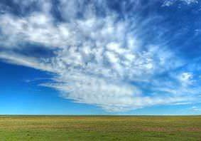
Central Shortgrass Prairie at the Pawnee National Grassland, CO. Photo by Michael Menefee.
Southeastern Colorado Canyons along the Purgatoire River Watershed
CNHP and BLM Ecologists test preliminary wetland monitoring methods.

About Us

About Us
Biennial Report
Strategic Plan
Conserving Biodiversity
Contact Us
Staff Directory
Careers
Employment
Internship
Volunteer
Meetings
The NatureServe Network
Partners

Related Topics

Request Data
Tracking Lists
Contribute Data
Heritage Network Ranking System
About CNHP Data
Maps & GIS Map Layers

Web Projects

  • CODEX - Colorado’s Conservation Data Explorer
  • Rare Plant Guide Online
  • Colorado Wetland Info Center
  • COMaP - Colorado Protected Lands
  • Colorado Bat Working Group
  • STReaMS - Endangered Fishes Database
  • Colorado Native Plant Database Data Portal

About Us

  • About Us
  • Conserving Biodiversity
  • Contact Us
  • Staff Directory
  • Careers
  • The NatureServe Network
  • Partners
  • Site Map
Warner College of Natural Resources Logo
  • Apply to CSU
  • Equal Opportunity
  • Disclaimer
  • Privacy Statement
  • Search CSU
  • CSU Land Acknowledgement
  • CSU Principles of Community
© 2025 Colorado Natural Heritage Program
Colorado State University Logo
  • About Us
    ▼
    • About Us
      ▼
      • Biennial Report
      • Strategic Plan
    • Conserving Biodiversity
    • Contact Us
    • Staff Directory
    • Careers
      ▼
      • Employment
      • Internship
      • Volunteer
    • Meetings
    • The NatureServe Network
    • Partners
  • Our Work
    ▼
    • Ecology
    • Wetlands
    • Plants
    • Animals
    • Climate Change
    • Education
    • Invasive Species
    • Statewide Natural Heritage Survey
  • Our Services
    ▼
    • Database Development
    • GIS Analysis & Modeling
    • Mapping
    • Surveys & Inventories
    • Monitoring & Assessment
    • Conservation Planning
    • Private Lands Conservation
  • Our Data
    ▼
    • About CNHP Data
    • Request Data
    • Contribute Data
    • Download Data
    • Tracking Lists
    • Potential Conservation Areas
    • Help & Documentation
  • Maps
    ▼
    • (CODEX) Conservation Data Explorer
    • CNHP Spatial Layers
    • Wetlands Mapper
    • COMaP
  • Library
    ▼
    • Reports
    • Tracking Lists
    • Potential Conservation Areas
    • Field Guides
      ▼
      • Rare Plant Guide
      • Colorado Wetland Field Guides
  • Blog
  • Use CODEX Conservation Data Explorer

  • Donate Now