Colorado Natural Heritage Program Logo Colorado Natural Heritage Program Logo CNHP
  • About Us
    • About Us
      • Biennial Report
      • Strategic Plan
    • Conserving Biodiversity
    • Contact Us
    • Staff Directory
    • Careers
      • Employment
      • Internship
      • Volunteer
    • Meetings
    • The NatureServe Network
    • Partners
  • Our Work
    • Ecology
    • Wetlands
    • Plants
    • Animals
    • Climate Change
    • Education
    • Invasive Species
    • Statewide Natural Heritage Survey
  • Our Services
    • Database Development
    • GIS Analysis & Modeling
    • Mapping
    • Surveys & Inventories
    • Monitoring & Assessment
    • Conservation Planning
    • Private Lands Conservation
  • Our Data
    • About CNHP Data
    • Request Data
    • Contribute Data
    • Download Data
    • Tracking Lists
    • Potential Conservation Areas
    • Help & Documentation
  • Maps
    • (CODEX) Conservation Data Explorer
    • CNHP Spatial Layers
    • Wetlands Mapper
    • COMaP
  • Library
    • Reports
    • Tracking Lists
    • Potential Conservation Areas
    • Field Guides
      • Rare Plant Guide
      • Colorado Wetland Field Guides
  • Blog
  • Use CODEX Conservation Data Explorer

  • Donate Now

Climate Change Vulnerability Assessments

Click a link below for details.

  • Assessment for Colorado Bureau of Land Management
  • Colorado Wildlife Action Plan Enhancement
  • Assessments in Southwest Colorado
  • Triangulation in Climate Change Vulnerability Assessment

Assessment for Colorado Bureau of Land Management

Back to top

The BLM administers 8.4 million acres of land and more than 29 million acres of sub‐surface mineral estate in Colorado. CNHP collaborated with BLM scientists and managers to evaluate vulnerability to: climate change for ecosystems, animals, and rare plants of concern for BLM in Colorado; model future habitat suitability for pinyon pine, two juniper species, and six cold-water fish species; and refine our statewide vulnerability assessment for select ecological systems in the San Luis Valley. Our maps, reports, and other deliverables were created to help BLM managers identify places where action may mitigate the effects of climate change, recognize potential novel conditions that may require additional analysis, and characterize uncertainties inherent in the process. View our reports and summary of findings.

CCVA for Colorado BLM

Social Science Counterpart: Colleagues at NREL and Western State Colorado University conducted parallel studies investigating vulnerabilities of social-ecological systems, including ranching and recreation-based livelihoods. We are pleased to share the results of their work with the Little Snake and Gunnison Field Offices here.

Left-click to view, and right-click to download.

Below are links to Assessment for Colorado Bureau of Land Management Reports

  • Adaptation in the face of environmental change: supporting information for Colorado BLM
  • Climate Change Vulnerability Assessment for Colorado Bureau of Land Management
  • Ecological Vulnerability Assessment: Summary of Finding [Fact Sheet]
  • Modeling Ecological Response To Support Adaptation Strategies: Summary of Finding [Fact Sheet]
  • Modeling Fish Habitat Response To Support Climate Adaptation Strategies: Summary of Finding [Fact Sheet]

Below are links to Social Science Report and Fact Sheets

  • Colorado Bureau of Land Management: Social Vulnerability Assessment
  • Colorado Bureau of Land Management: Social Climate Vulnerability Assessment (Summary of Findings - Field Office Case Studies)
  • Colorado Bureau of Land Management: Social Climate Vulnerability Assessment (Summary of Findings - Review of BLM Documents And Plans)
  • Colorado Bureau of Land Management: Social Climate Vulnerability Assessment (Summary of Findings - Indicators Analysis)

Below are links to Colorado Bureau of Land Management San Luis Valley Field Office Reports

  • Social Vulnerability Assessment to Climate Variability and Change: Final Report 2020
  • Social Vulnerability to Climate Change Assessment: Summary of Findings - Spatial Indicators Assessment
  • Social Vulnerability to Climate Change Assessment: Summary of Findings - Interviews with BLM Staff and Users
For information, contact Lee Grunau.

Colorado Wildlife Action Plan Enhancement

Back to top

CNHP worked closely with CPW and the North Central Climate Science Center to conduct a statewide habitat vulnerability assessment for Colorado’s new State Wildlife Action Plan. This work earned us an Honorable Mention in the 2017 Climate Adaptation Leadership Awards for Natural Resources. Of the 18 habitat targets evaluated, three were assigned high overall vulnerability ranks, nine were assigned moderate overall vulnerability ranks, and six were assigned low overall vulnerability ranks.

Conservation planning in action

Left-click to view, and right-click to download.

Below are links to Colorado Wildlife Action Plan Enhancement Reports

  • Colorado Wildlife Action Plan Enhancement: Climate Change Vulnerability Assessment
For information, contact Michelle Fink

Assessments in Southwest Colorado

Back to top

CNHP has evaluated rare plants, animals, and ecosystems for vulnerability to climate change across southwest Colorado.
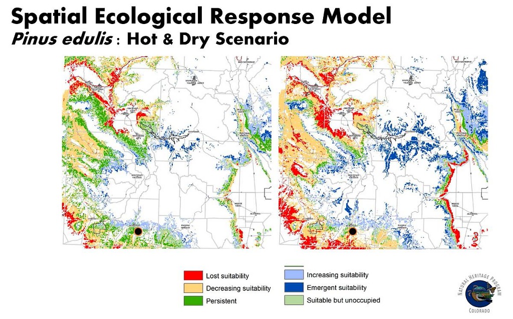
San Juan Pinus edulis models

Left-click to view, and right-click to download.

Below are links to Assessments in Southwest Colorado Reports

  • Climate Change Vulnerability Assessment for Rare Plants of the San Juan Region of Colorado
  • Gunnison Basin: Climate Change Vulnerability Assessment for the Gunnison Climate Working Group
  • San Juan / Tres Rios Climate Change Ecosystem Vulnerability Assessment
  • Treeline Monitoring in the San Juan Mountains
For information, contact Michelle Fink

Triangulation in Climate Change Vulnerability Assessment

Back to top

We compared outcomes of three vulnerability assessments focused on major vegetation types in Colorado and categorized sources of disagreements between the assessments in a 2017 paper in Regional Environmental Change. Read the article here.

Some potential outcomes of triangulating with three bearings to locate a single point
For information, contact Michelle Fink

Our Work

Ecology
Wetlands
Plants
Animals
Climate Change
Education
Invasive Species

Related Topics

Database Development
GIS Analysis & Modeling
Mapping
Surveys & Inventories
Monitoring & Assessment
Conservation Planning

Web Projects

  • CODEX - Colorado’s Conservation Data Explorer
  • Rare Plant Guide Online
  • Colorado Wetland Info Center
  • COMaP - Colorado Protected Lands
  • Colorado Bat Working Group
  • STReaMS - Endangered Fishes Database
  • Colorado Native Plant Database Data Portal

About Us

  • About Us
  • Conserving Biodiversity
  • Contact Us
  • Staff Directory
  • Careers
  • The NatureServe Network
  • Partners
  • Site Map
Warner College of Natural Resources Logo
  • Apply to CSU
  • Equal Opportunity
  • Disclaimer
  • Privacy Statement
  • Search CSU
  • CSU Land Acknowledgement
  • CSU Principles of Community
© 2025 Colorado Natural Heritage Program
Colorado State University Logo
  • About Us
    ▼
    • About Us
      ▼
      • Biennial Report
      • Strategic Plan
    • Conserving Biodiversity
    • Contact Us
    • Staff Directory
    • Careers
      ▼
      • Employment
      • Internship
      • Volunteer
    • Meetings
    • The NatureServe Network
    • Partners
  • Our Work
    ▼
    • Ecology
    • Wetlands
    • Plants
    • Animals
    • Climate Change
    • Education
    • Invasive Species
    • Statewide Natural Heritage Survey
  • Our Services
    ▼
    • Database Development
    • GIS Analysis & Modeling
    • Mapping
    • Surveys & Inventories
    • Monitoring & Assessment
    • Conservation Planning
    • Private Lands Conservation
  • Our Data
    ▼
    • About CNHP Data
    • Request Data
    • Contribute Data
    • Download Data
    • Tracking Lists
    • Potential Conservation Areas
    • Help & Documentation
  • Maps
    ▼
    • (CODEX) Conservation Data Explorer
    • CNHP Spatial Layers
    • Wetlands Mapper
    • COMaP
  • Library
    ▼
    • Reports
    • Tracking Lists
    • Potential Conservation Areas
    • Field Guides
      ▼
      • Rare Plant Guide
      • Colorado Wetland Field Guides
  • Blog
  • Use CODEX Conservation Data Explorer

  • Donate Now