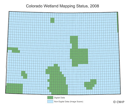
Colorado Natural Heritage Program Logo Colorado Natural Heritage Program Logo CNHP
  • About Us
    • About Us
      • Biennial Report
      • Strategic Plan
    • Conserving Biodiversity
    • Contact Us
    • Staff Directory
    • Careers
      • Employment
      • Internship
      • Volunteer
    • Meetings
    • The NatureServe Network
    • Partners
  • Our Work
    • Ecology
    • Wetlands
    • Plants
    • Animals
    • Climate Change
    • Education
    • Invasive Species
  • Our Services
    • Database Development
    • GIS Analysis & Modeling
    • Mapping
    • Surveys & Inventories
    • Monitoring & Assessment
    • Conservation Planning
  • Our Data
    • About CNHP Data
    • Request Data
    • Contribute Data
    • Download Data
    • Tracking Lists
    • PCA Reports
    • Help & Documentation
  • Maps
    • CNHP Spatial Layers
    • Wetlands Mapper
    • COMaP
    • Conservation Environmental Review Tool
  • Library
    • Reports
    • PCA Reports
    • Tracking Lists
    • Field Guides
      • Rare Plant Guide
      • Colorado Wetland Field Guides
  • Blog
  • Donate Now

Viewing Category - GIS

CNHP Blog

Colorado Wetland Mapping – Then and Now

March 9, 2012
by Gabrielle Smith, CNHP Wetland Mapping and GIS Specialist In the 1970’s the US Fish and Wildlife Service […]
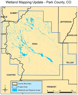
Filed Under: GIS, Wetlands

And the Wetland Mapping Continues…

January 24, 2012
by Erick Carlson The Colorado Natural Heritage Program has been active in generating wetlands maps for the state […]
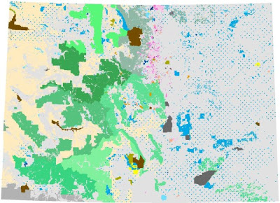
Filed Under: Ecology, GIS, Wetlands

CNHP takes over maintenance of COMaP

October 19, 2011
The Colorado Ownership, Management, and Protection (COMaP) project was initiated by Dr. David Theobald, Associate Professor in the […]

Filed Under: About CNHP, Collaborations, Conservation Data Services, GIS

Data on website updated for 2011

August 18, 2011
The data that we have available for download and viewing on our website has been updated for 2011. […]

Filed Under: About CNHP, Conservation Data Services, GIS, Potential Conservation Areas

CNHP supplies spatial analysis training to sister program

November 22, 2010
We were visited last week by Andrea Hazelton, Botanist for the Navajo Natural Heritage Program, who came up […]

Filed Under: Collaborations, Conservation Planning, Friends and Partners, GIS

Data on website updated for 2010

August 5, 2010
The data that we have available for download and viewing on our website has been updated for 2010. […]

Filed Under: About CNHP, GIS, Potential Conservation Areas

  • « Previous Page
  • 1
  • 2
  • 3
  • 4
  • Next Page »

About Us

About Us
Conserving Biodiversity
Contact Us
Staff Directory
Careers
Employment
Internship
Volunteer
Meetings
The NatureServe Network
Partners

Our Work

Ecology
Wetlands
Plants
Animals
Climate Change
Education
Invasive Species

Blog Archive

Blog Categories

Web Projects

  • Rare Plant Guide Online
  • Colorado Wetland Info Center
  • COMaP - Colorado Protected Lands
  • Colorado Bat Working Group
  • STReaMS - Endangered Fishes Database

About Us

  • About Us
  • Conserving Biodiversity
  • Contact Us
  • Staff Directory
  • Careers
  • The NatureServe Network
  • Partners
  • Site Map
Warner College of Natural Resources Logo
  • Apply to CSU
  • Equal Opportunity
  • Disclaimer
  • Privacy Statement
  • Search CSU
  • CSU Land Acknowledgement
  • CSU Principles of Community
© 2026 Colorado Natural Heritage Program
Colorado State University Logo
  • About Us
    ▼
    • About Us
      ▼
      • Biennial Report
      • Strategic Plan
    • Conserving Biodiversity
    • Contact Us
    • Staff Directory
    • Careers
      ▼
      • Employment
      • Internship
      • Volunteer
    • Meetings
    • The NatureServe Network
    • Partners
  • Our Work
    ▼
    • Ecology
    • Wetlands
    • Plants
    • Animals
    • Climate Change
    • Education
    • Invasive Species
  • Our Services
    ▼
    • Database Development
    • GIS Analysis & Modeling
    • Mapping
    • Surveys & Inventories
    • Monitoring & Assessment
    • Conservation Planning
  • Our Data
    ▼
    • About CNHP Data
    • Request Data
    • Contribute Data
    • Download Data
    • Tracking Lists
    • PCA Reports
    • Help & Documentation
  • Maps
    ▼
    • CNHP Spatial Layers
    • Wetlands Mapper
    • COMaP
    • Conservation Environmental Review Tool
  • Library
    ▼
    • Reports
    • PCA Reports
    • Tracking Lists
    • Field Guides
      ▼
      • Rare Plant Guide
      • Colorado Wetland Field Guides
  • Blog
  • Donate Now