

By: Sierra Crumbaker
(Colorado Natural Heritage Program)
If you’ve ever cursed at thickets of traffic while driving along northern I-25 in Colorado, you’ve more than likely noticed two distinct peaks dominating the Front Range’s Rocky Mountains. These same peaks tower over the backdrop of CNHP’s logo and are visible from certain spots on Colorado State University’s campus where CNHP’s office is housed (presuming buildings, trees, and stadiums don’t get in the way).

Longs Peak (right) and Mount Meeker (left) viewed from Estes Park in January. (Photo credit: Sierra Crumbaker)
At 14,259 feet tall, Longs Peak (right in the logo) is Colorado’s fifteenth tallest and northernmost fourteener, while Mount Meeker (left) stands at 13,916 feet and snags the fifteenth tallest spot for thirteeners. Picturesque and easily accessible from the Front Range, these peaks are popular among Coloradoans and tourists alike.
A highlight of Rocky Mountain National Park, Longs Peak is a popular climbing destination that draws thousands of hikers each year to attempt its summit. While there are three ascent routes, the most popular is the Keyhole Route, named for the unique rock formation the trail passes through to reach the western side of the mountain. Beginning at approximately 9,400 feet, this 15-mile round-trip route tackles 5,000 vertical feet and is rated a Class 3 difficulty because it requires scrambling and hand-holds in the mile and half near the top.

The Keyhole, at the top of the Boulder Field. To reach the summit, climbers must pass through this gap to traverse the west side of the mountain. The remaining 1.5 miles involve using hand-holds and scrambling, and the route is marked by bullseyes painted onto boulders. (Photo credit: Sierra Crumbaker)
In summertime, common afternoon thunderstorms increase risk from lightning strikes since more than half of the trail is above tree-line. In winter, the route is no longer considered a scramble, but a technical mountaineering ascent that requires proper equipment. While fatalities have occurred on the mountain, good preparation, conditions, and judgment can lead to a stunning, unforgettable climb and amazing views of the park and the expansive Front Range.
For those less interested in committing 10-15 hours to the climb, there are plenty of other options to explore the spectacular mountain. Many people take the East Longs Peak Trail just part of the way to the summit, stopping at the Boulder Field or Keyhole.
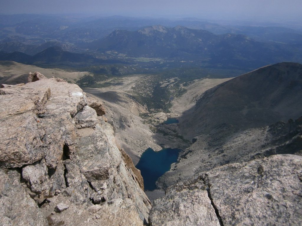
View of Chasm Lake from the summit. (Photo credit: Sierra Crumbaker)
The Chasm Lake Trail, which diverts off the East Longs Peak Trail after 3 miles, leads to the alpine lake at the base of Longs’ flat, eastern face, known as the Diamond. A total of 8.5 miles round-trip, this hike offers fantastic views above tree-line and an abundance of Rocky Mountain Columbine flowers just off the trail in late summer months.
If you’re interested in summiting Longs, here are a couple of great resources on what to expect and how to best prepare:
- https://www.nps.gov/romo/planyourvisit/longspeak.htm
- https://www.nps.gov/romo/planyourvisit/upload/keyhole_route_2011.pdf
- https://www.14ers.com/route.php?route=long1&peak=Longs+Peak
This article is part of mini series about five species/things in our logo that embodies the ecology, botany and zoology work CNHP is committed to.
- CNHP’s Logo Part 1: Bat an Eyelash, Blue Grama
- CNHP’s Logo Part 2: Nature’s Little Serial Killer, the Loggerhead Shrike
- CNHP’s Logo Part 3: Payson Lupine and Silvery Lupine
- CNHP’s Logo Part 4: Royalty in Decline, the Regal Fritillary
- CNHP’s Logo Part 5: Pinnacle of Rocky Mountain National Park, Longs Peak

