Colorado Natural Heritage Program Logo Colorado Natural Heritage Program Logo CNHP
  • About Us
    • About Us
      • Biennial Report
      • Strategic Plan
    • Conserving Biodiversity
    • Contact Us
    • Staff Directory
    • Careers
      • Employment
      • Internship
      • Volunteer
    • Meetings
    • The NatureServe Network
    • Partners
  • Our Work
    • Ecology
    • Wetlands
    • Plants
    • Animals
    • Climate Change
    • Education
    • Invasive Species
  • Our Services
    • Database Development
    • GIS Analysis & Modeling
    • Mapping
    • Surveys & Inventories
    • Monitoring & Assessment
    • Conservation Planning
  • Our Data
    • About CNHP Data
    • Request Data
    • Contribute Data
    • Download Data
    • Tracking Lists
    • PCA Reports
    • Help & Documentation
  • Maps
    • CNHP Spatial Layers
    • Wetlands Mapper
    • COMaP
    • Conservation Environmental Review Tool
  • Library
    • Reports
    • PCA Reports
    • Tracking Lists
    • Field Guides
      • Rare Plant Guide
      • Colorado Wetland Field Guides
  • Blog
  • Donate Now

Ecological Systems: Southern Rocky Mountain Pinyon-Juniper

January 18, 2012

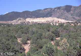
The Southern Rocky Mountain Pinyon-Juniper ecological system is similar to the Colorado Plateau Pinyon-Juniper system, but with a more restricted distribution in south central Colorado. In Colorado, the southern Rocky Mountain pinyon-juniper woodlands are found in the south central part of the state, around the San Luis Valley, southern mountain front east to Mesa de Maya, and north to the Arkansas River Valley and Palmer divide. Elevations range from about 5,000 to 9,000 feet. Pinyon-juniper also occurs in a limited distribution on the eastern plains near the Purgatoire River. These are open woodlands of warm, dry sites on mountain slopes, mesas, plateaus, and ridges. Pinyon pine and/or one-seed juniper dominate the tree layer, and Rocky Mountain juniper may be present at higher elevations. In the canyons and tablelands to the east, pinyon is absent, and this system is replaced by the Southern Rocky Mountain Juniper Woodland and Savanna system. Understory layers are variable and may be dominated by shrubs, grasses, sparse vegetation, or bare ground.

Southern Rocky Mountain pinyon-juniper covers some 1.25 million acres in Colorado. Ownership is divided about equally between private and public ownership, with the Bureau of Land Management responsible for the majority of federal holdings. Pinyon-juniper ecological systems have declined in both extent and quality compared to historic norms, although there are a number of very large patches remaining. Threats include urban development, recreation (especially motorized recreation), invasive species (most notably an increase in cheatgrass in the understory, which has led to increasing fire ignitions), and energy development.

Overall biodiversity, threat, and protection status scores for
Colorado Plateau Pinyon-Juniper in Colorado.
 
 
 A “windrose” graph depicting Colorado Plateau Pinyon-Juniper status for individual scoring factors.

SHARE
FACEBOOK
TWITTER
LINKEDIN
REDDIT
EMAIL
Filed Under: Biodiversity Scorecard, Conservation Planning, Ecology

And the Wetland Mapping Continues…
Botany A to Z: Cirsium

About Us

About Us
Conserving Biodiversity
Contact Us
Staff Directory
Careers
Employment
Internship
Volunteer
Meetings
The NatureServe Network
Partners

Our Work

Ecology
Wetlands
Plants
Animals
Climate Change
Education
Invasive Species

Blog Archive

Blog Categories

Web Projects

  • Rare Plant Guide Online
  • Colorado Wetland Info Center
  • COMaP - Colorado Protected Lands
  • Colorado Bat Working Group
  • STReaMS - Endangered Fishes Database

About Us

  • About Us
  • Conserving Biodiversity
  • Contact Us
  • Staff Directory
  • Careers
  • The NatureServe Network
  • Partners
  • Site Map
Warner College of Natural Resources Logo
  • Apply to CSU
  • Equal Opportunity
  • Disclaimer
  • Privacy Statement
  • Search CSU
  • CSU Land Acknowledgement
  • CSU Principles of Community
© 2026 Colorado Natural Heritage Program
Colorado State University Logo
  • About Us
    ▼
    • About Us
      ▼
      • Biennial Report
      • Strategic Plan
    • Conserving Biodiversity
    • Contact Us
    • Staff Directory
    • Careers
      ▼
      • Employment
      • Internship
      • Volunteer
    • Meetings
    • The NatureServe Network
    • Partners
  • Our Work
    ▼
    • Ecology
    • Wetlands
    • Plants
    • Animals
    • Climate Change
    • Education
    • Invasive Species
  • Our Services
    ▼
    • Database Development
    • GIS Analysis & Modeling
    • Mapping
    • Surveys & Inventories
    • Monitoring & Assessment
    • Conservation Planning
  • Our Data
    ▼
    • About CNHP Data
    • Request Data
    • Contribute Data
    • Download Data
    • Tracking Lists
    • PCA Reports
    • Help & Documentation
  • Maps
    ▼
    • CNHP Spatial Layers
    • Wetlands Mapper
    • COMaP
    • Conservation Environmental Review Tool
  • Library
    ▼
    • Reports
    • PCA Reports
    • Tracking Lists
    • Field Guides
      ▼
      • Rare Plant Guide
      • Colorado Wetland Field Guides
  • Blog
  • Donate Now