The black-tailed prairie dog (BTPD) is a keystone species whose colonies sustain an extraordinary diversity of wildlife—from burrowing owls and mountain plovers to pollinators, bison, and the critically endangered black-footed ferret. Yet today, across their historical range, prairie dogs occupy less than 4% of suitable habitat.
The Homes on the Range project was developed to identify where conservation actions for the BTPD ecosystem are most likely to succeed—both now and under future climate conditions. To do this, we combined high-resolution habitat modeling with social, political, and environmental data.
The outcome is a new suite of spatial decision-support tools designed to guide real-world conservation efforts across North America’s Central Grasslands.
North America’s Central Grasslands are among the most endangered ecosystems in the world, threatened by extensive habitat loss, fragmentation, and transformation. Historically, this region supported extraordinary wildlife abundance—bison, pronghorn, elk, wolves, and grizzly bears in numbers rivaling those of Africa’s Serengeti. Over the past century, however, the grasslands have been transformed into a domesticated landscape shaped by fences, crops, livestock, and complex jurisdictional boundaries that make large-scale conservation planning difficult. The result has been steep declines in native wildlife: prairie dogs and bison have been reduced by more than 95 percent, grassland birds by over 50 percent, and apex predators such as wolves and grizzlies have nearly disappeared.
Watch Video
This dramatic decline has spurred ambitious new initiatives, including the Central Grasslands Roadmap, the Great Plains Summit, WAFWA’s Western Grasslands Initiative, and the proposed North American Grasslands Conservation Act of 2024. Many of these efforts adopt an umbrella species strategy—protecting species whose conservation benefits entire ecosystems. At the center of many strategies is the black-tailed prairie dog, a keystone species that shapes and engineers grassland ecosystems. Through their burrowing and grazing, prairie dogs create open habitat and extensive burrow systems that support mountain plovers, burrowing owls, snakes, lizards, arthropods, and pollinators. Their colonies also provide more nutritious forage for bison and cattle, while serving as hunting grounds for coyotes, badgers, raptors, and the critically endangered black-footed ferret.
Despite their ecological importance, prairie dogs remain under threat from extermination campaigns, introduced plague, habitat loss, and ongoing conflict with human land use—especially livestock production. Their decline has triggered cascading losses in dependent species, most notably the black-footed ferret, North America’s most endangered mammal. These interconnected losses underscore the urgent need to identify and protect landscapes capable of sustaining healthy prairie dog complexes, while also navigating the social, political, and economic realities that determine where and how such ecosystems can persist.
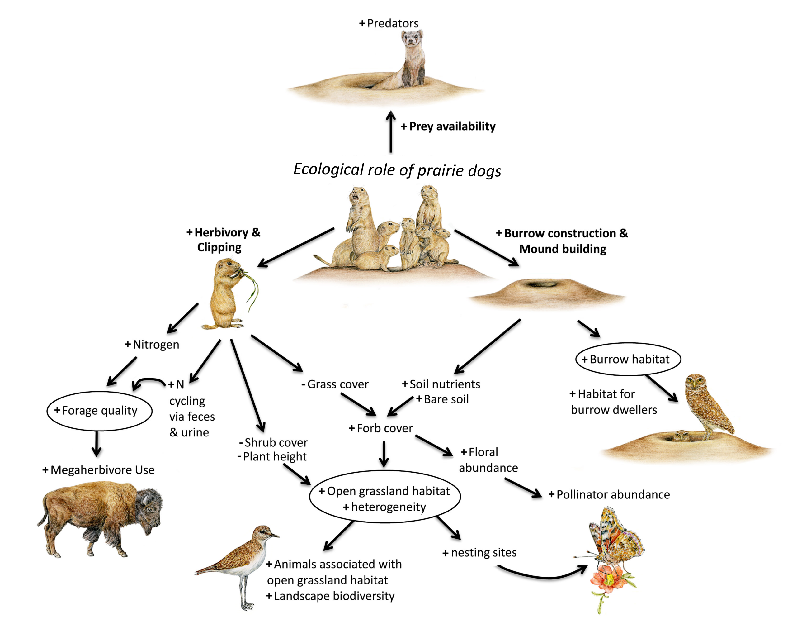
The ecological role of prairie dogs cascades throughout the prairie dog ecosystem. Plus (+) signs equal an increase in an ecosystem property as a result prairie dogs; minus (-) signs indicate a decrease. (Drawings by Sharyn Davidson; modified version from Davidson et al. 2012 Frontiers in Ecol & Environ)
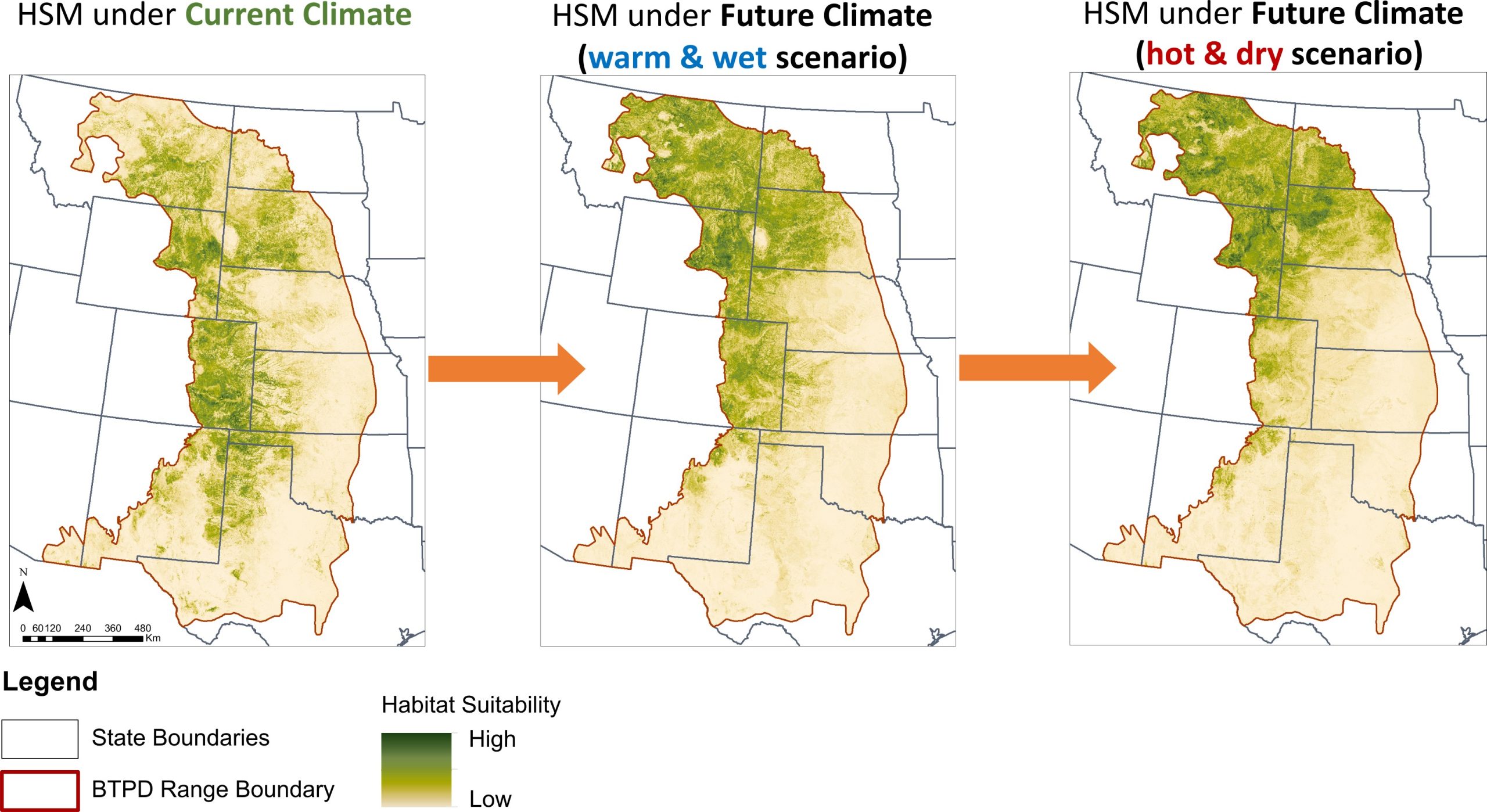
We developed a habitat suitability model (HSM) across the historical U.S. range of the black-tailed prairie dog, using an ensemble modeling approach (GLMM, Random Forest, Boosted Regression Trees) that integrated ecological and climatic variables. Predictions were made under current climate and two future climate scenarios (warm/wet and hot/dry), with spatial layers like soils, land cover, topography, and occurrence data.
- An estimated 20.8 million hectares of suitable grassland habitat remain, concentrated primarily in the western half of the historical range.
- Of this area, only about 782,521 hectares (~3.8%) are currently occupied. State-level estimates increase occupancy to roughly 1.9 million hectares (~9%).
- The habitat suitability model (HSM) predicts a northward shift in suitable habitat under climate change, with notable declines in the southern Central Grasslands.
- The HSM provides a powerful tool for planning coexistence with livestock, identifying transition zones, assessing connectivity, and guiding the targeting of incentive prov
| State | Area of low habitat suitability (ha) | Area of medium habitat suitability (ha) | Area of high habitat suitability (ha) | Area of medium + high habitat suitability (ha) | Area of medium + high habitat suitability occupied by BTPDs (ha) | Percent of medium + high habitat suitability occupied by BTPDs (%) |
|---|---|---|---|---|---|---|
| Arizona | 13,750 | 5,789 | 108 | 5,897 | 34 | 0.58% |
| Colorado | 1,338,636 | 1,558,562 | 4,216,600 | 5,775,162 | 532,251 | 9.22% |
| Kansas | 631,120 | 420,207 | 760,199 | 1,180,406 | 154,775 | 13.11% |
| Montana | 1,763,366 | 1,345,433 | 1,588,702 | 2,934,135 | 184,055 | 6.27% |
| Nebraska | 692,534 | 441,174 | 389,552 | 830,726 | 89,208 | 10.74% |
| New Mexico | 1,169,982 | 863,150 | 728,047 | 1,591,197 | 124,098 | 7.80% |
| North Dakota | 340,733 | 180,275 | 63,826 | 244,101 | 15,561 | 6.37% |
| Oklahoma | 280,290 | 212,791 | 480,503 | 693,294 | 81,224 | 11.72% |
| South Dakota | 1,711,314 | 1,277,664 | 1,470,485 | 2,748,149 | 224,145 | 8.16% |
| Texas | 1,018,266 | 804,629 | 1,064,014 | 1,868,643 | 238,871 | 12.78% |
| Wyoming | 1,064,272 | 1,021,180 | 1,961,438 | 2,982,618 | 288,606 | 9.68% |
| Entire US Range | 10,024,502 | 8,130,936 | 12,723,491 | 20,854,427 | 1,932,826 | 9.27% |
Building off the Habitat Suitability Model, we used a structured decision analysis and the Zonation prioritization framework to integrate ecological, political, social, and threat variables (including future climate, land use, habitat connectivity) to identify High Conservation Potential (HCP) landscapes (See spatial data layers HERE).
We provide a suite of HCP area scenarios to help inform different conservation and management interests, including those that consider projected climate change and jurisdictional boundaries. We created scenarios that involved current and future projected suitable BTPD habitat, across the BTPD range within the United States; these were our Range-Wide scenarios. Additionally, because conservation policies and funding decisions are often made by political entities, we also identified State-Level conservation priorities, under both present and projected future climate. Our State-Level analysis sought conservation solutions within each of the states’ boundaries only, so do not consider a rangewide perspective. This way, each state has information on conservation priorities within their own jurisdictional boundaries.
Key Findings:
- Our findings highlight the large conservation potential for black-tailed prairie dogs (BTPDs) and associated species. The maps we produced can be incorporated into broader, multi-species conservation planning efforts underway across the Central Grasslands of North America.
- Landscapes with the highest conservation potential for the BTPD ecosystem are concentrated in the western portion of the current and historical range.
- Colorado, Montana, South Dakota, Wyoming, and northeastern New Mexico contain the grassland landscapes with the highest conservation potential (link to Table 2) and most of it occurs on private land (65%) (link to Landownership table)
- The top 30% of high-conservation-potential (HCP) landscapes encompass about 22% of the historical distribution of BTPDs.
- Within this, the top 10% (96,944 km²) demonstrate especially high potential when integrating social, threat, ecological, and climate variables.
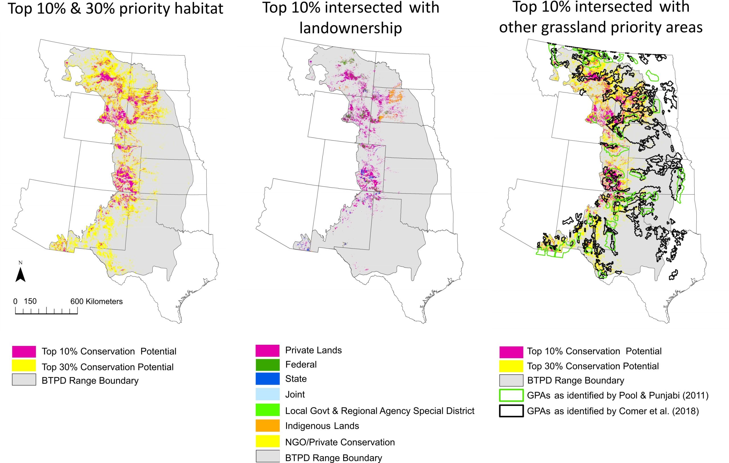
- Across all three climate scenarios, 65% of these top 10% HCP areas occur on private land, compared to 24% on public land.
- HCP areas tend to align with the western range, where intact grasslands persist and remain resilient under climate change.
- Differences emerge between state-level and range-wide priorities, particularly in southern and eastern states. We recommend that each state emphasize those areas that continue to rank as priorities at the state level, while also considering priorities identified through the range-wide perspective.
- The HCP areas we identify overlap with many regions highlighted in other landscape-level conservation priority analyses for the Central Grasslands (e.g., Comer et al. 2018; Pool & Panjabi 2011), while also revealing extensive new regions of grassland priority.
Maps of range-wide high conservation potential habitat (top 10% and 30%, across current and future climates) for the black-tailed prairie dog ecosystem (left), and the top 10% intersected with landownership (middle) and other grassland priority areas identified by Pool and Punjabi and by Comer et al. 2018 (right)
| State | Area (km2) | Percent (%) |
|---|---|---|
| Colorado | 24,084 | 24.8 |
| Montana | 19,401 | 20.0 |
| South Dakota | 19,331 | 19.9 |
| Wyoming | 18,947 | 19.5 |
| New Mexico | 7,082 | 7.3 |
| Nebraska | 2,525 | 2.6 |
| Arizona | 1,845 | 1.9 |
| Texas | 1,552 | 1.6 |
| Oklahoma | 1,059 | 1.1 |
| North Dakota | 699 | 0.7 |
| Kansas | 420 | 0.4 |
| Total | 96,944 | 100 |
| Landownership | Area (km2) | Percent (%) |
|---|---|---|
| Private | 63,447 | 65.4 |
| Federal | 14,021 | 14.5 |
| State | 9,347 | 9.6 |
| Indigenous lands | 7,779 | 8.0 |
| NGO/private conservation | 2,250 | 2.3 |
| Local/Regional | 100 | 0.1 |
| Total | 96,944 | 100 |
Prairie dogs face a trifecta of challenges: plague, habitat loss, and high social conflict with ranching. Although they are ecologically critical, they are still often subject to lethal control.
Our research pinpoints where coexistence strategies are most likely to succeed by combining spatial data with social, ecological, and land-use realities. The resulting tools provide decision support at a fine scale (90-meter resolution), allowing planners to align conservation investments with the landscapes of highest potential.
By offering this insight, the tools enable practical, durable decision making—directing resources to areas where outcomes are most likely to last. In addition, the maps can be layered with priority areas for other species and initiatives—including sage-grouse, lesser prairie-chickens, grassland birds, bison, and black-footed ferrets—and can directly support national conservation goals such as the 30x30 initiative.
All data layers, habitat suitability layers, conservation prioritization maps, and supporting documentation are available through Data Dryad.
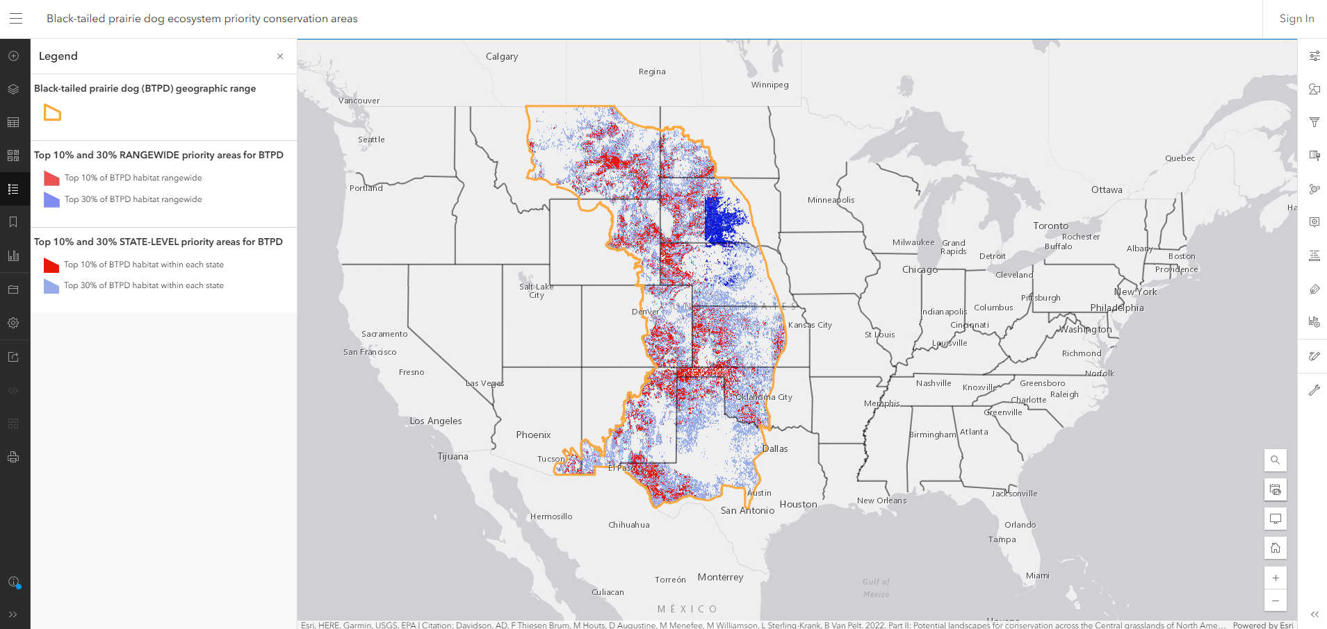
An interactive map viewer is also available, allowing users to explore habitat and conservation layers, toggle between climate scenarios, and focus on specific geographies of interest. This tool supports transparency, accessibility, and practical use by conservation practitioners and policymakers.
For more information, contact project lead Dr. Ana Davidson.

Colorado Natural Heritage Program
Colorado State University

Western Association of Fish & Wildlife Agencies

The Nature Conservancy and the Universidade Federal do Rio Grande do Sul
Prairie Dog Coalition
Humane World for Animals
USDA-Agricultural Research Service

Colorado Natural Heritage Program
Colorado State University

Kansas Biological Survey & Center for Ecological Research
University of Kansas

Colorado Natural Heritage Program
Colorado State University

Boise State University
KUNC (audio)
Mountain West could be key for prairie dog conservation, study finds
Colorado State University: Protecting the Plains: Conserving prairie dogs will revitalize North America’s grasslands
North Central Climate Adaptation Science Center : Conserving Central Grasslands and Keystone Species
Newsbreak: Colorado Scientists Map Out Hope for Prairie Dogs and Their Grassland Home


