Colorado Natural Heritage Program Logo Colorado Natural Heritage Program Logo CNHP
  • About Us
    • About Us
      • Biennial Report
      • Strategic Plan
    • Conserving Biodiversity
    • Contact Us
    • Staff Directory
    • Careers
      • Employment
      • Internships
      • Volunteer
    • Meetings
    • The NatureServe Network
    • Partners
  • Our Work
    • Ecology
    • Wetlands
    • Plants
    • Animals
    • Climate Change
    • Education
    • Invasive Species
    • Statewide Natural Heritage Survey
  • Our Services
    • Database Development
    • GIS Analysis & Modeling
    • Mapping
    • Surveys & Inventories
    • Monitoring & Assessment
    • Conservation Planning
    • Private Lands Conservation
  • Our Data
    • About CNHP Data
    • Request Data
    • Contribute Data
    • Download Data
    • Tracking Lists
    • Potential Conservation Areas
    • Help & Documentation
  • Maps
    • (CODEX) Conservation Data Explorer
    • CNHP Spatial Layers
    • Wetlands Mapper
    • COMaP
  • Library
    • Reports
    • Tracking Lists
    • Potential Conservation Areas
    • Field Guides
      • Rare Plant Guide
      • Colorado Wetland Field Guides
  • Blog
  • Use CODEX Conservation Data Explorer

  • Donate Now

Gunnison Basin Climate Change Adaptation and Wetland Restoration Monitoring

Wet meadows and riparian areas occupy a small proportion of the sagebrush ecosystem in the Gunnison Basin, yet provide critically important habitat for many species. These mesic areas, in an otherwise semi-arid climate, are vital to the life cycle of the federally threatened Gunnison sage-grouse, providing important brood-rearing habitat for the grouse to raise their young chicks. These meadows also provide important food and cover for insects, pollinators, neo-tropical migratory birds, mule deer, elk, and forage for domestic livestock.
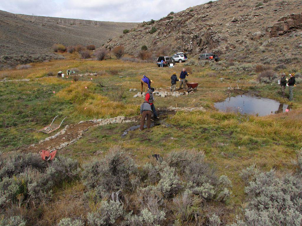
Volunteers build a media luna in Wolf Creek, 2012.

Many riparian areas and wet meadows in the Gunnison Basin have been degraded by erosion and past land uses, resulting in incised gullies and lowered water tables. Intense episodic droughts, such as the one in 2002, have exacerbated these problems. As our temperatures continue to rise, droughts and intense runoff events that increase erosion are likely to become more frequent. If these already uncommon habitats degrade further, the many plants and animals that depend on them will suffer, including the Gunnison sage-grouse.

Wolf Creek in 2016, four years after media luna was installed.


Simple technique helps ranchers and threatened sage grouse weather drought

A study led by CSU researcher Renée Rondeau has found that strategically placing rocks in the wet meadows of Gunnison’s sagebrush hills slows water, reconnects the floodplain and increases wetland plant cover by 40%, despite unprecedented drought in the West. This technique benefits ranchers and the Gunnison sage grouse, which is federally listed as a threatened species.


Results published in the Journal of Restoration Ecology show that low-tech restoration structures were effective at rewetting intermittent streams and wet meadows within the arid landscape, even though six of the nine monitored years were considered drought years. Non-native invasive weeds declined, while forbs and grasses important to sage grouse and livestock operations increased.


WCRN - Side-by-side photos showing, at left, volunteers constructing a rock structure for wetland restoration, and, at right, a restored green pasture
On left: Gunnison Wet Meadow Restoration Project volunteers construct a rock structure used to reduce erosion and restore watersheds. Photo on right shows the increase in wetland cover from 2012 to 2019. Photos by Claudia Strijek and Renee Rondeau
WCRN - Side-by-side photos showing, at left, volunteers constructing a rock structure for wetland restoration, and, at right, a restored green pasture On left: Gunnison Wet Meadow Restoration Project volunteers construct a rock structure used to reduce erosion and restore watersheds. Photo on right shows the increase in wetland cover from 2012 to 2019. Photos by Claudia Strijek and Renee Rondeau
2019 Wings Across the Americas Conservation Award: Habitat Conservation Partnership Award.
2019 The Climate Adaptation Leadership Award for Natural Resources
Broad Partnership Category

Since only about 5,000 of these birds remain in the world, they cannot withstand more loss of this important habitat. Degraded riparian areas and wet meadows also pose challenges to ranchers, who are already experiencing other pressures. To help both wildlife and ranchers, we need to restore these habitats and make them better able to withstand change.

Log and fabric structure prevents headcutting. Photo by Renee Rondeau.
Monitoring at Wolf Creek. Photo by Renee Rondeau.
Wildlands Restoration Volunteers build a one rock dam, West Flat Top Mountain. Photo by Betsy Neely.

Left-click to view, and right-click to download.

Below are links to project resources:

  • Gunnison Basin Wet Meadow and Riparian Restoration and Resilience-Building Project
  • Hand-Built Structures for Restoring Degraded Meadows in Sagebrush Rangelands
For information, contact Renee Rondeau.

Our Work

Ecology
Wetlands
Plants
Animals
Climate Change
Education
Invasive Species

Related Topics

Database Development
GIS Analysis & Modeling
Mapping
Surveys & Inventories
Monitoring & Assessment
Conservation Planning

Web Projects

  • CODEX - Colorado’s Conservation Data Explorer
  • Rare Plant Guide Online
  • Colorado Wetland Info Center
  • COMaP - Colorado Protected Lands
  • Colorado Bat Working Group
  • STReaMS - Endangered Fishes Database
  • Colorado Native Plant Database Data Portal

About Us

  • About Us
  • Conserving Biodiversity
  • Contact Us
  • Staff Directory
  • Careers
  • The NatureServe Network
  • Partners
  • Site Map
Warner College of Natural Resources Logo
  • Apply to CSU
  • Equal Opportunity
  • Disclaimer
  • Privacy Statement
  • Search CSU
  • CSU Land Acknowledgement
  • CSU Principles of Community
© 2025 Colorado Natural Heritage Program
Colorado State University Logo
  • About Us
    ▼
    • About Us
      ▼
      • Biennial Report
      • Strategic Plan
    • Conserving Biodiversity
    • Contact Us
    • Staff Directory
    • Careers
      ▼
      • Employment
      • Internships
      • Volunteer
    • Meetings
    • The NatureServe Network
    • Partners
  • Our Work
    ▼
    • Ecology
    • Wetlands
    • Plants
    • Animals
    • Climate Change
    • Education
    • Invasive Species
    • Statewide Natural Heritage Survey
  • Our Services
    ▼
    • Database Development
    • GIS Analysis & Modeling
    • Mapping
    • Surveys & Inventories
    • Monitoring & Assessment
    • Conservation Planning
    • Private Lands Conservation
  • Our Data
    ▼
    • About CNHP Data
    • Request Data
    • Contribute Data
    • Download Data
    • Tracking Lists
    • Potential Conservation Areas
    • Help & Documentation
  • Maps
    ▼
    • (CODEX) Conservation Data Explorer
    • CNHP Spatial Layers
    • Wetlands Mapper
    • COMaP
  • Library
    ▼
    • Reports
    • Tracking Lists
    • Potential Conservation Areas
    • Field Guides
      ▼
      • Rare Plant Guide
      • Colorado Wetland Field Guides
  • Blog
  • Use CODEX Conservation Data Explorer

  • Donate Now