Colorado Natural Heritage Program Logo Colorado Natural Heritage Program Logo CNHP
  • About Us
    • About Us
      • Biennial Report
      • Strategic Plan
    • Conserving Biodiversity
    • Contact Us
    • Staff Directory
    • Careers
      • Employment
      • Internship
      • Volunteer
    • Meetings
    • The NatureServe Network
    • Partners
  • Our Work
    • Ecology
    • Wetlands
    • Plants
    • Animals
    • Climate Change
    • Education
    • Invasive Species
    • Statewide Natural Heritage Survey
  • Our Services
    • Database Development
    • GIS Analysis & Modeling
    • Mapping
    • Surveys & Inventories
    • Monitoring & Assessment
    • Conservation Planning
    • Private Lands Conservation
  • Our Data
    • About CNHP Data
    • Request Data
    • Contribute Data
    • Download Data
    • Tracking Lists
    • Potential Conservation Areas
    • Help & Documentation
  • Maps
    • (CODEX) Conservation Data Explorer
    • CNHP Spatial Layers
    • Wetlands Mapper
    • COMaP
  • Library
    • Reports
    • Tracking Lists
    • Potential Conservation Areas
    • Field Guides
      • Rare Plant Guide
      • Colorado Wetland Field Guides
  • Blog
  • Use CODEX Conservation Data Explorer

  • Donate Now

Southeast Colorado Conservation Easement Database

CNHP partnered with Great Outdoors Colorado and numereous land trusts on a comprehensive report on all conservation easements held in a five county area in southeast Colorado including Bent, Crowley, Otero, Prowers, and Pueblo counties. The purpose of this project was to collect and disclose comprehensive information on conservation easements in the study area.

This project centralizes information on these southeast Colorado conservation easements, including pulling together into one database, all deeds of conservation easement, amendments, corrections, and reassignments. For each easement, key characteristics are described, including the size of the property encumbered, the date of recording, the names of the grantor and the grantee, the certification status of the grantee, the stated conservation purpose(s), and the land use restrictions.

CNHP’s Conservation Data Services team delivered a custom database solution that centralized all of this information into an online database to support report production and provide comprehensive data for this study.
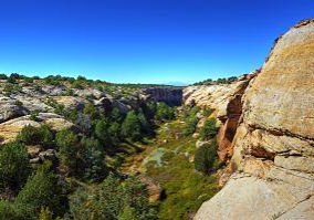
Fern Canyon in SECO.
A view of JE Canyon from Dead Horse Point.
An ancient juniper slowly decomposes on the walls of JE Canyon.

We worked closely with the programs to:

  • Design a complex relational database to meet report requirements.
  • Develop a web interface to deliver the content securely, intuitively, and quickly.
  • Support attachment uploads to centralize all deeds of trust in one location.
For information, contact Michael Menefee.

Our Work

Ecology
Wetlands
Plants
Animals
Climate Change
Education
Invasive Species

Related Topics

Database Development
GIS Analysis & Modeling
Mapping
Surveys & Inventories
Monitoring & Assessment
Conservation Planning

Web Projects

  • CODEX - Colorado’s Conservation Data Explorer
  • Rare Plant Guide Online
  • Colorado Wetland Info Center
  • COMaP - Colorado Protected Lands
  • Colorado Bat Working Group
  • STReaMS - Endangered Fishes Database
  • Colorado Native Plant Database Data Portal

About Us

  • About Us
  • Conserving Biodiversity
  • Contact Us
  • Staff Directory
  • Careers
  • The NatureServe Network
  • Partners
  • Site Map
Warner College of Natural Resources Logo
  • Apply to CSU
  • Equal Opportunity
  • Disclaimer
  • Privacy Statement
  • Search CSU
  • CSU Land Acknowledgement
  • CSU Principles of Community
© 2025 Colorado Natural Heritage Program
Colorado State University Logo
  • About Us
    ▼
    • About Us
      ▼
      • Biennial Report
      • Strategic Plan
    • Conserving Biodiversity
    • Contact Us
    • Staff Directory
    • Careers
      ▼
      • Employment
      • Internship
      • Volunteer
    • Meetings
    • The NatureServe Network
    • Partners
  • Our Work
    ▼
    • Ecology
    • Wetlands
    • Plants
    • Animals
    • Climate Change
    • Education
    • Invasive Species
    • Statewide Natural Heritage Survey
  • Our Services
    ▼
    • Database Development
    • GIS Analysis & Modeling
    • Mapping
    • Surveys & Inventories
    • Monitoring & Assessment
    • Conservation Planning
    • Private Lands Conservation
  • Our Data
    ▼
    • About CNHP Data
    • Request Data
    • Contribute Data
    • Download Data
    • Tracking Lists
    • Potential Conservation Areas
    • Help & Documentation
  • Maps
    ▼
    • (CODEX) Conservation Data Explorer
    • CNHP Spatial Layers
    • Wetlands Mapper
    • COMaP
  • Library
    ▼
    • Reports
    • Tracking Lists
    • Potential Conservation Areas
    • Field Guides
      ▼
      • Rare Plant Guide
      • Colorado Wetland Field Guides
  • Blog
  • Use CODEX Conservation Data Explorer

  • Donate Now