Colorado Natural Heritage Program Logo Colorado Natural Heritage Program Logo CNHP
  • About Us
    • About Us
      • Biennial Report
      • Strategic Plan
    • Conserving Biodiversity
    • Contact Us
    • Staff Directory
    • Careers
      • Employment
      • Internship
      • Volunteer
    • Meetings
    • The NatureServe Network
    • Partners
  • Our Work
    • Ecology
    • Wetlands
    • Plants
    • Animals
    • Climate Change
    • Education
    • Invasive Species
  • Our Services
    • Database Development
    • GIS Analysis & Modeling
    • Mapping
    • Surveys & Inventories
    • Monitoring & Assessment
    • Conservation Planning
  • Our Data
    • About CNHP Data
    • Request Data
    • Contribute Data
    • Download Data
    • Tracking Lists
    • PCA Reports
    • Help & Documentation
  • Maps
    • CNHP Spatial Layers
    • Wetlands Mapper
    • COMaP
    • Conservation Environmental Review Tool
  • Library
    • Reports
    • PCA Reports
    • Tracking Lists
    • Field Guides
      • Rare Plant Guide
      • Colorado Wetland Field Guides
  • Blog
  • Donate Now

Introduction to a CNHP/ESS Capstone Collaboration- A Land Conservation Analysis

April 11, 2018

Colorado Ownership, Management and Protection map by land status.

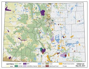
The Colorado Ownership, Management and Protection Map (COMaP, v20170505)

At CNHP, we are excited to introduce an undergraduate student-led project that will complete land protection analyses within Colorado this semester. CNHP team members David Anderson and Michael Menefee are facilitating ecosystem science and sustainability (ESS) students Phillipo Admasu, Connor McCarty, Joshua Otis, Stephen Pfeiffer, Walter Quinones, and Sarah Whipple in their senior capstone course project. The course, titled “Practicing Sustainability,” hopes to provide students relevant applications to their degree through projects with various stakeholders across the Front Range. In regard to CNHP, we hope to get a better understanding of the importance of land protection statuses in Colorado for not only our records, but also for all of our personal stakeholders.

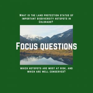
We are focusing on two questions within this project. First, what is the land protection status of important biodiversity hotspots in Colorado? Second, which hotspots are most at risk, and which are well conserved? While these questions may seem broad, the students will provide specific case studies and suggestions so that our stakeholders can move forward with better solutions for land protection within Colorado’s biodiversity hotspots. CNHP is providing the resources to complete the basic analysis of hotspots, but the students have a choice as to how they synthesize the data for communication purposes.

Through this project, students will complete GIS data analyses, external research through scientific and additional map layer sources, and engagement initiatives between stakeholders and protected areas. Some of the ideas that students might tackle include: looking at the geological relationship between hotspots and geography, the relationship of habitat degradation to biodiversity, potential gaps in current datasets, and the severity index of hotspots in relationship to local/state-level and international conservation (IUCN) status rankings.

If you are interested in learning more about the project, feel free to leave a comment or drop CNHP an email. This project will continue to grow as the semester goes on, and we are willing to shift our project outcomes based on other stakeholder interests.

SHARE
FACEBOOK
TWITTER
LINKEDIN
REDDIT
EMAIL
Filed Under: About CNHP, Collaborations, Education, Friends and Partners, GIS, Students

ESS440 Student Guest Blog Post: Biodiversity Hotspots and the Benefits of Large-scale Land Protection.
Viewing Landscapes the Way Bats Might View them: Little Brown Bat Roost Use in Colorado

About Us

About Us
Conserving Biodiversity
Contact Us
Staff Directory
Careers
Employment
Internship
Volunteer
Meetings
The NatureServe Network
Partners

Our Work

Ecology
Wetlands
Plants
Animals
Climate Change
Education
Invasive Species

Blog Archive

Blog Categories

Web Projects

  • Rare Plant Guide Online
  • Colorado Wetland Info Center
  • COMaP - Colorado Protected Lands
  • Colorado Bat Working Group
  • STReaMS - Endangered Fishes Database

About Us

  • About Us
  • Conserving Biodiversity
  • Contact Us
  • Staff Directory
  • Careers
  • The NatureServe Network
  • Partners
  • Site Map
Warner College of Natural Resources Logo
  • Apply to CSU
  • Equal Opportunity
  • Disclaimer
  • Privacy Statement
  • Search CSU
  • CSU Land Acknowledgement
  • CSU Principles of Community
© 2026 Colorado Natural Heritage Program
Colorado State University Logo
  • About Us
    ▼
    • About Us
      ▼
      • Biennial Report
      • Strategic Plan
    • Conserving Biodiversity
    • Contact Us
    • Staff Directory
    • Careers
      ▼
      • Employment
      • Internship
      • Volunteer
    • Meetings
    • The NatureServe Network
    • Partners
  • Our Work
    ▼
    • Ecology
    • Wetlands
    • Plants
    • Animals
    • Climate Change
    • Education
    • Invasive Species
  • Our Services
    ▼
    • Database Development
    • GIS Analysis & Modeling
    • Mapping
    • Surveys & Inventories
    • Monitoring & Assessment
    • Conservation Planning
  • Our Data
    ▼
    • About CNHP Data
    • Request Data
    • Contribute Data
    • Download Data
    • Tracking Lists
    • PCA Reports
    • Help & Documentation
  • Maps
    ▼
    • CNHP Spatial Layers
    • Wetlands Mapper
    • COMaP
    • Conservation Environmental Review Tool
  • Library
    ▼
    • Reports
    • PCA Reports
    • Tracking Lists
    • Field Guides
      ▼
      • Rare Plant Guide
      • Colorado Wetland Field Guides
  • Blog
  • Donate Now