Colorado Natural Heritage Program Logo Colorado Natural Heritage Program Logo CNHP
  • About Us
    • About Us
      • Biennial Report
      • Strategic Plan
    • Conserving Biodiversity
    • Contact Us
    • Staff Directory
    • Careers
      • Employment
      • Internship
      • Volunteer
    • Meetings
    • The NatureServe Network
    • Partners
  • Our Work
    • Ecology
    • Wetlands
    • Plants
    • Animals
    • Climate Change
    • Education
    • Invasive Species
  • Our Services
    • Database Development
    • GIS Analysis & Modeling
    • Mapping
    • Surveys & Inventories
    • Monitoring & Assessment
    • Conservation Planning
  • Our Data
    • About CNHP Data
    • Request Data
    • Contribute Data
    • Download Data
    • Tracking Lists
    • PCA Reports
    • Help & Documentation
  • Maps
    • CNHP Spatial Layers
    • Wetlands Mapper
    • COMaP
    • Conservation Environmental Review Tool
  • Library
    • Reports
    • PCA Reports
    • Tracking Lists
    • Field Guides
      • Rare Plant Guide
      • Colorado Wetland Field Guides
  • Blog
  • Donate Now

CSU Students Create Project with CNHP on Priority Conservation Areas and Land Ownership Using COMaP Data

May 8, 2017

Group Members: Tatum VanDam, Madison Wood, Alexa Grafton, Dylan Heser, Anna Banwart, and Nicole Chirban

Through our senior level Ecosystem Science and Sustainability class, we were given the opportunity to connect with resources from around Fort Collins to create a research and development capstone project. Working alongside the Colorado Natural Heritage Program (CNHP), we were able to communicate and develop a research project that allowed us to apply the knowledge we have gained through our four years of education at Colorado State University.

Our team was lucky to be advised by David Anderson, the director and chief scientist at CNHP. David helped us navigate COMaP (Colorado Ownership, Management, and Protection) to determine the distribution of land management and ownership types within specific parcels of land. Each parcel of land that CNHP has deemed of significant ecological/ biological importance is known as a Potential Conservation Area (PCA).

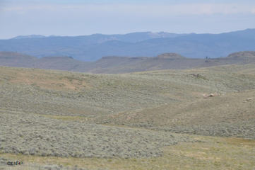
We chose sites of interest for our project based on a biological significance scale from B1 – B5, B1 being of highest importance and B5 being of lower/lowest importance. Of those sites, we chose three B1/B2 PCAs to focus on, including one in Gunnison Basin, Horsetooth Reservoir Hogbacks, and Rabbit Mountain. B1 areas are described as having outstanding biodiversity significance, and B2 areas are described as having very high biodiversity significance. Each site has a unique characteristic that gives it the potential to be a conservation site. In the Gunnison Basin, the sage brush area is of high importance (B1) to conserve because of the habitat it provides to the native Sage Grouse. The Horsetooth Reservoir Hogbacks have a high importance rating (B2) because of the occurrence of vulnerable plant communities and butterfly species native to the area. Like the Horsetooth Reservoir Hogbacks and Gunnison Basin, Rabbit Mountain is also rated highly as a B1 because of the native shrub lands and habitat for Black-tailed Prairie Dogs.

Our group worked extremely hard to evaluate the data of land management and ownership types given to us by CNHP. Madison, a master creator in GIS, was an amazing leader for the analysis of COMaP data. She was able to take an enormous amount of land data and break it down to a manageable size. Madison created a Storymap visual presentation with the help of Anna, Alexa, Dylan, and Nicole. CNHP will use this presentation for public education on the management of local lands and the distribution of PCA’s, allowing for more public understanding and possibly better collaboration on private ownership lands.

Finishing up the semester, we presented our findings at the ESS symposium in April as well as in class for our stakeholders from CNHP. This project was a growing experience as well as an opportunity to build connections with CNHP. We would like to thank all who took the time to help us with this project and we hope CNHP finds much benefit in our final product.

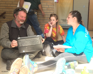
CNHP group meeting with Dave 
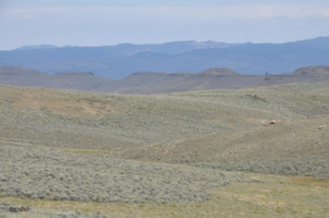
Gunnison Basin: Sage Brush

SHARE
FACEBOOK
TWITTER
LINKEDIN
REDDIT
EMAIL
Filed Under: CSU Classes, CSU Students, Potential Conservation Areas

Human Disturbance in Colorado’s Potential Conservation Areas
CSU ESS 440: Investigating Colorado’s Ever-Changing Riparian Habitat

About Us

About Us
Conserving Biodiversity
Contact Us
Staff Directory
Careers
Employment
Internship
Volunteer
Meetings
The NatureServe Network
Partners

Our Work

Ecology
Wetlands
Plants
Animals
Climate Change
Education
Invasive Species

Blog Archive

Blog Categories

Web Projects

  • Rare Plant Guide Online
  • Colorado Wetland Info Center
  • COMaP - Colorado Protected Lands
  • Colorado Bat Working Group
  • STReaMS - Endangered Fishes Database

About Us

  • About Us
  • Conserving Biodiversity
  • Contact Us
  • Staff Directory
  • Careers
  • The NatureServe Network
  • Partners
  • Site Map
Warner College of Natural Resources Logo
  • Apply to CSU
  • Equal Opportunity
  • Disclaimer
  • Privacy Statement
  • Search CSU
  • CSU Land Acknowledgement
  • CSU Principles of Community
© 2026 Colorado Natural Heritage Program
Colorado State University Logo
  • About Us
    ▼
    • About Us
      ▼
      • Biennial Report
      • Strategic Plan
    • Conserving Biodiversity
    • Contact Us
    • Staff Directory
    • Careers
      ▼
      • Employment
      • Internship
      • Volunteer
    • Meetings
    • The NatureServe Network
    • Partners
  • Our Work
    ▼
    • Ecology
    • Wetlands
    • Plants
    • Animals
    • Climate Change
    • Education
    • Invasive Species
  • Our Services
    ▼
    • Database Development
    • GIS Analysis & Modeling
    • Mapping
    • Surveys & Inventories
    • Monitoring & Assessment
    • Conservation Planning
  • Our Data
    ▼
    • About CNHP Data
    • Request Data
    • Contribute Data
    • Download Data
    • Tracking Lists
    • PCA Reports
    • Help & Documentation
  • Maps
    ▼
    • CNHP Spatial Layers
    • Wetlands Mapper
    • COMaP
    • Conservation Environmental Review Tool
  • Library
    ▼
    • Reports
    • PCA Reports
    • Tracking Lists
    • Field Guides
      ▼
      • Rare Plant Guide
      • Colorado Wetland Field Guides
  • Blog
  • Donate Now