Colorado Natural Heritage Program Logo Colorado Natural Heritage Program Logo CNHP
  • About Us
    • About Us
      • Biennial Report
      • Strategic Plan
    • Conserving Biodiversity
    • Contact Us
    • Staff Directory
    • Careers
      • Employment
      • Internship
      • Volunteer
    • Meetings
    • The NatureServe Network
    • Partners
  • Our Work
    • Ecology
    • Wetlands
    • Plants
    • Animals
    • Climate Change
    • Education
    • Invasive Species
  • Our Services
    • Database Development
    • GIS Analysis & Modeling
    • Mapping
    • Surveys & Inventories
    • Monitoring & Assessment
    • Conservation Planning
  • Our Data
    • About CNHP Data
    • Request Data
    • Contribute Data
    • Download Data
    • Tracking Lists
    • PCA Reports
    • Help & Documentation
  • Maps
    • CNHP Spatial Layers
    • Wetlands Mapper
    • COMaP
    • Conservation Environmental Review Tool
  • Library
    • Reports
    • PCA Reports
    • Tracking Lists
    • Field Guides
      • Rare Plant Guide
      • Colorado Wetland Field Guides
  • Blog
  • Donate Now

Wetland Monitoring in Great Sand Dunes National Park and Preserve

October 31, 2016

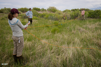
One of CNHP’s Wetlands crew spent July collecting data at wetland sites in Great Sand Dunes National Park and Preserve in southern Colorado. The park and preserve is home to about 1,700 bison, and a large elk herd. The wetland monitoring data collected will be used to aid in planning and decision making as part of the Park’s ungulate management plan process. The wetland crew braved warm weather and abundant mosquitoes to collect vegetation, soil and ungulate use data, and install game cameras at over 20 sites.

The
CNHP Wetlands crew and National Park Service Inventory and Monitoring employees
after training in Great Sand Dunes National Park. 

Lexine
Long and Erin Borgman setting up a vegetation monitoring plot in Great Sand
Dunes National Park. 

When not in Great Sand Dunes National Park, the wetland crew also worked on a project surveying fen wetlands close to state highways for a project sponsored by the Colorado Department of Transportation. Fens are groundwater-fed wetlands with 40 or more centimeters of organic soil (often peat). Organic soil accumulates very slowly – at approximately 20cm in 1,000 years, so fens are an incredibly important wetland resource in Colorado. The crew got to spend their time working in the beautiful mountain passes of Colorado, and saw many interesting wetlands while collecting vegetation and soil data for the project.

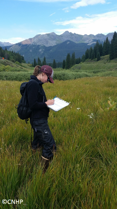
Lexine
Long collecting vegetation data in a fen in the San Juan mountains.
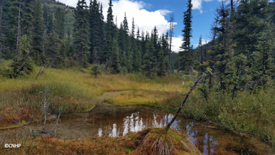
A fen
wetland in the San Juan mountains. 

SHARE
FACEBOOK
TWITTER
LINKEDIN
REDDIT
EMAIL
Filed Under: CDOT, National Parks, Wetlands

An Intern’s Adventures (and Ant Bites)
Photographing Wing Venetation Patterns of Little Brown Bats

About Us

About Us
Conserving Biodiversity
Contact Us
Staff Directory
Careers
Employment
Internship
Volunteer
Meetings
The NatureServe Network
Partners

Our Work

Ecology
Wetlands
Plants
Animals
Climate Change
Education
Invasive Species

Blog Archive

Blog Categories

Web Projects

  • Rare Plant Guide Online
  • Colorado Wetland Info Center
  • COMaP - Colorado Protected Lands
  • Colorado Bat Working Group
  • STReaMS - Endangered Fishes Database

About Us

  • About Us
  • Conserving Biodiversity
  • Contact Us
  • Staff Directory
  • Careers
  • The NatureServe Network
  • Partners
  • Site Map
Warner College of Natural Resources Logo
  • Apply to CSU
  • Equal Opportunity
  • Disclaimer
  • Privacy Statement
  • Search CSU
  • CSU Land Acknowledgement
  • CSU Principles of Community
© 2026 Colorado Natural Heritage Program
Colorado State University Logo
  • About Us
    ▼
    • About Us
      ▼
      • Biennial Report
      • Strategic Plan
    • Conserving Biodiversity
    • Contact Us
    • Staff Directory
    • Careers
      ▼
      • Employment
      • Internship
      • Volunteer
    • Meetings
    • The NatureServe Network
    • Partners
  • Our Work
    ▼
    • Ecology
    • Wetlands
    • Plants
    • Animals
    • Climate Change
    • Education
    • Invasive Species
  • Our Services
    ▼
    • Database Development
    • GIS Analysis & Modeling
    • Mapping
    • Surveys & Inventories
    • Monitoring & Assessment
    • Conservation Planning
  • Our Data
    ▼
    • About CNHP Data
    • Request Data
    • Contribute Data
    • Download Data
    • Tracking Lists
    • PCA Reports
    • Help & Documentation
  • Maps
    ▼
    • CNHP Spatial Layers
    • Wetlands Mapper
    • COMaP
    • Conservation Environmental Review Tool
  • Library
    ▼
    • Reports
    • PCA Reports
    • Tracking Lists
    • Field Guides
      ▼
      • Rare Plant Guide
      • Colorado Wetland Field Guides
  • Blog
  • Donate Now