Colorado Natural Heritage Program Logo Colorado Natural Heritage Program Logo CNHP
  • About Us
    • About Us
      • Biennial Report
      • Strategic Plan
    • Conserving Biodiversity
    • Contact Us
    • Staff Directory
    • Careers
      • Employment
      • Internship
      • Volunteer
    • Meetings
    • The NatureServe Network
    • Partners
  • Our Work
    • Ecology
    • Wetlands
    • Plants
    • Animals
    • Climate Change
    • Education
    • Invasive Species
  • Our Services
    • Database Development
    • GIS Analysis & Modeling
    • Mapping
    • Surveys & Inventories
    • Monitoring & Assessment
    • Conservation Planning
  • Our Data
    • About CNHP Data
    • Request Data
    • Contribute Data
    • Download Data
    • Tracking Lists
    • PCA Reports
    • Help & Documentation
  • Maps
    • CNHP Spatial Layers
    • Wetlands Mapper
    • COMaP
    • Conservation Environmental Review Tool
  • Library
    • Reports
    • PCA Reports
    • Tracking Lists
    • Field Guides
      • Rare Plant Guide
      • Colorado Wetland Field Guides
  • Blog
  • Donate Now

CNHP Map Will Support Governor's Colorado Beautiful Initiative

August 20, 2015

Colorado Natural Heritage Program director David Anderson, along with staff members Amy Greenwell and Michael Menefee, were thrilled to participate in The Outdoors Summit in downtown Denver this summer. The Summit convened to help launch new initiatives to protect, preserve and enhance the state’s great outdoors and natural areas. Conservation leaders from around the state attended the event. Speakers included Governor John Hickenlooper and former Interior Secretary Ken Salazar among many other notable participants.


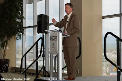
Governor John Hickenlooper presents his Colorado Beautiful plan at the Outdoors Summit in Denver, Colorado.

During the Summit, Governor Hickenlooper rolled out his Colorado Beautiful plan, an exciting conservation initiative that ultimately aims to enable every Coloradan to live within a 10-minute walk of an open space natural area. Great Outdoors Colorado (GOCO) has awarded $15.6 million in grants to support the Colorado Beautiful plan. A hallmark of the plan will be the creation of an interactive trail and recreational lands map. The map will use CNHP’s existing map of Colorado’s protected areas, called The Colorado Ownership, Management, and Protection (COMaP). COMaP is a dataset maintained by CNHP and the CSU Geospatial Centroid.

The complete Colorado Beautiful map is scheduled for completion in 2016. The map will also help guide plans to preserve and strategically protect Colorado’s most threatened landscapes, waterways and urban open spaces. It will also be used to identify 16 high-priority trail projects to help connect people to more recreational opportunities. The map will include all the state’s trails, open spaces, parks and protected lands in a single site. “Colorado Beautiful, we believe, is not only about connecting our parks, trails and scenic lands, but about connecting people to the outdoor delights that set Colorado apart as a special place,” Hickenlooper said. “It’s important to bring our newest generations outside, away from electronic distractions and into the splendor of our waterways, forests, wildlife, grasslands, mountains and canyons.”


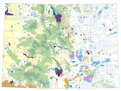
An image of the Colorado Ownership, Management, and Protection map (COMaP) that will be integrated into the Colorado Beautiful map proposed by Governor Hickenlooper.

SHARE
FACEBOOK
TWITTER
LINKEDIN
REDDIT
EMAIL
Filed Under: Conferences, Conservation Data Services, Maps

Let’s Hear it For the Interns, Student Employees, and Volunteers!
Local Film Explores Ecological Challenges On Colorado’s Front Range

About Us

About Us
Conserving Biodiversity
Contact Us
Staff Directory
Careers
Employment
Internship
Volunteer
Meetings
The NatureServe Network
Partners

Our Work

Ecology
Wetlands
Plants
Animals
Climate Change
Education
Invasive Species

Blog Archive

Blog Categories

Web Projects

  • Rare Plant Guide Online
  • Colorado Wetland Info Center
  • COMaP - Colorado Protected Lands
  • Colorado Bat Working Group
  • STReaMS - Endangered Fishes Database

About Us

  • About Us
  • Conserving Biodiversity
  • Contact Us
  • Staff Directory
  • Careers
  • The NatureServe Network
  • Partners
  • Site Map
Warner College of Natural Resources Logo
  • Apply to CSU
  • Equal Opportunity
  • Disclaimer
  • Privacy Statement
  • Search CSU
  • CSU Land Acknowledgement
  • CSU Principles of Community
© 2025 Colorado Natural Heritage Program
Colorado State University Logo
  • About Us
    ▼
    • About Us
      ▼
      • Biennial Report
      • Strategic Plan
    • Conserving Biodiversity
    • Contact Us
    • Staff Directory
    • Careers
      ▼
      • Employment
      • Internship
      • Volunteer
    • Meetings
    • The NatureServe Network
    • Partners
  • Our Work
    ▼
    • Ecology
    • Wetlands
    • Plants
    • Animals
    • Climate Change
    • Education
    • Invasive Species
  • Our Services
    ▼
    • Database Development
    • GIS Analysis & Modeling
    • Mapping
    • Surveys & Inventories
    • Monitoring & Assessment
    • Conservation Planning
  • Our Data
    ▼
    • About CNHP Data
    • Request Data
    • Contribute Data
    • Download Data
    • Tracking Lists
    • PCA Reports
    • Help & Documentation
  • Maps
    ▼
    • CNHP Spatial Layers
    • Wetlands Mapper
    • COMaP
    • Conservation Environmental Review Tool
  • Library
    ▼
    • Reports
    • PCA Reports
    • Tracking Lists
    • Field Guides
      ▼
      • Rare Plant Guide
      • Colorado Wetland Field Guides
  • Blog
  • Donate Now