Colorado Natural Heritage Program Logo Colorado Natural Heritage Program Logo CNHP
  • About Us
    • About Us
      • Biennial Report
      • Strategic Plan
    • Conserving Biodiversity
    • Contact Us
    • Staff Directory
    • Careers
      • Employment
      • Internship
      • Volunteer
    • Meetings
    • The NatureServe Network
    • Partners
  • Our Work
    • Ecology
    • Wetlands
    • Plants
    • Animals
    • Climate Change
    • Education
    • Invasive Species
  • Our Services
    • Database Development
    • GIS Analysis & Modeling
    • Mapping
    • Surveys & Inventories
    • Monitoring & Assessment
    • Conservation Planning
  • Our Data
    • About CNHP Data
    • Request Data
    • Contribute Data
    • Download Data
    • Tracking Lists
    • PCA Reports
    • Help & Documentation
  • Maps
    • CNHP Spatial Layers
    • Wetlands Mapper
    • COMaP
    • Conservation Environmental Review Tool
  • Library
    • Reports
    • PCA Reports
    • Tracking Lists
    • Field Guides
      • Rare Plant Guide
      • Colorado Wetland Field Guides
  • Blog
  • Donate Now

CNHP Pilots Water Chemistry Measurements in Wetland Condition Assessments

June 22, 2015

By Laurie Gilligan, CNHP Wetland Ecologist

The wetlands team kicked off their water chemistry data collection pilot project in the Lower Arkansas Basin under perfect weather conditions: rain, lightning, mud, and more rain! All of the spring rain has filled playas that have not been saturated in years, and is greening up the Arkansas River floodplain and its marshes. These conditions will give our crew the opportunity to test how well our data collection methods work in waters with high variability in sediment and water levels. However, accessing sites safely has meant dodging the notoriously fierce thunderstorms that roll over the open southeastern plains.

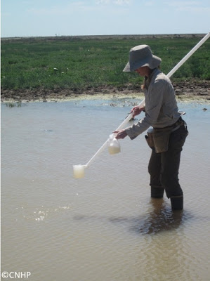
Joanna Lemly, CNHP wetland ecologist, collects water samples
in a playa on the southeastern plains of Colorado.
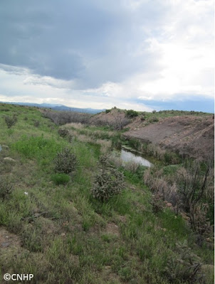
Pools within a small stream outside Florence, Colorado provide
good habitat for native plains fish species.

CNHP is excited to add water chemistry measurements to this year’s wetland assessments. While water chemistry measurements are frequently taken in lakes and rivers, more research is needed on nutrient levels, metal loads, and other water chemistry measurements in shallow vegetated wetlands. By adding water chemistry measurements to our wetland condition assessments, we can begin to observe the relationships between the wetland’s water chemistry and its overall condition. The first step with this pilot year of water quality sampling is to refine protocols and analysis, and to get a glimpse of the range of variation in water chemistry parameters that we may see in the plains.

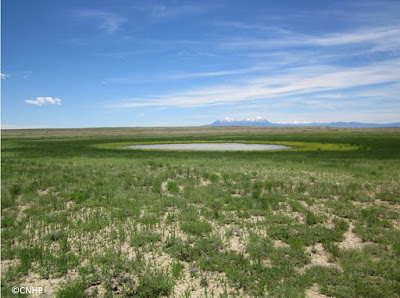
Playa on Bureau of Land Management (BLM) land in Huerfano County, Colorado. With extra spring moisture in 2015, many playas in the Lower Arkansas Basin showed concentric rings of vegetation-in this case, an inner ring of spreading yellowcress (Rorripa sinuata).

SHARE
FACEBOOK
TWITTER
LINKEDIN
REDDIT
EMAIL
Filed Under: Arkansas River Basin, Field Techniques, Water Quality, Wetlands

Climate Trajectories for Colorado's Terrestrial Ecosystems
New Graham's Beardtongue Population Found

About Us

About Us
Conserving Biodiversity
Contact Us
Staff Directory
Careers
Employment
Internship
Volunteer
Meetings
The NatureServe Network
Partners

Our Work

Ecology
Wetlands
Plants
Animals
Climate Change
Education
Invasive Species

Blog Archive

Blog Categories

Web Projects

  • Rare Plant Guide Online
  • Colorado Wetland Info Center
  • COMaP - Colorado Protected Lands
  • Colorado Bat Working Group
  • STReaMS - Endangered Fishes Database

About Us

  • About Us
  • Conserving Biodiversity
  • Contact Us
  • Staff Directory
  • Careers
  • The NatureServe Network
  • Partners
  • Site Map
Warner College of Natural Resources Logo
  • Apply to CSU
  • Equal Opportunity
  • Disclaimer
  • Privacy Statement
  • Search CSU
  • CSU Land Acknowledgement
  • CSU Principles of Community
© 2026 Colorado Natural Heritage Program
Colorado State University Logo
  • About Us
    ▼
    • About Us
      ▼
      • Biennial Report
      • Strategic Plan
    • Conserving Biodiversity
    • Contact Us
    • Staff Directory
    • Careers
      ▼
      • Employment
      • Internship
      • Volunteer
    • Meetings
    • The NatureServe Network
    • Partners
  • Our Work
    ▼
    • Ecology
    • Wetlands
    • Plants
    • Animals
    • Climate Change
    • Education
    • Invasive Species
  • Our Services
    ▼
    • Database Development
    • GIS Analysis & Modeling
    • Mapping
    • Surveys & Inventories
    • Monitoring & Assessment
    • Conservation Planning
  • Our Data
    ▼
    • About CNHP Data
    • Request Data
    • Contribute Data
    • Download Data
    • Tracking Lists
    • PCA Reports
    • Help & Documentation
  • Maps
    ▼
    • CNHP Spatial Layers
    • Wetlands Mapper
    • COMaP
    • Conservation Environmental Review Tool
  • Library
    ▼
    • Reports
    • PCA Reports
    • Tracking Lists
    • Field Guides
      ▼
      • Rare Plant Guide
      • Colorado Wetland Field Guides
  • Blog
  • Donate Now