

Terrestrial Ecological Systems are dynamic groupings of
plant and/or animal communities that: 1) occur together on the landscape; and
2) are linked by similar ecological processes, underlying abiotic environmental
factors, or gradients; and 3) form a readily identifiable unit on the ground
(Comer et al. 2003). In order to assess the health of Colorado’s major
ecosystems, CNHP developed a dataset of large-sized (>20,000 acres) ecological
system patches for the “State of Colorado’s Biodiversity” project.
Ecological systems were derived from the Southwest Regional Gap Analysis
Project landcover dataset (USGS 2004).
Developing this dataset enabled CNHP to identify at-risk
ecosystems in Colorado. Individual patches were ranked on a scale of 1-10 based
on overall condition status, threat status and protection status. Top threats
were assigned to each patch. The results of the analysis show that many of
Colorado’s major ecosystems are intact, but only two are effectively conserved.
Shortgrass prairie is by far the most altered ecological system. Nearly half of
the shortgrass prairie in Colorado has been lost in the past century; however,
several large, high quality areas still exist. While these data are an
effective tool for broadly measuring current successes, they also highlight
intact landscapes that pose great opportunities for future conservation
efforts.
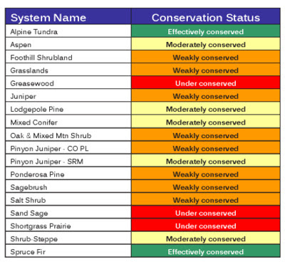 |
| Table with Conservation Status Ranks of Major Ecological Systems in Colorado |
These
data are bundled in an ESRI geodatabase and can be downloaded from CNHP’s
website here. As
always, if you need more detailed information or need data for commercial use,
please contact our Data Distribution Coordinator.
data are bundled in an ESRI geodatabase and can be downloaded from CNHP’s
website here. As
always, if you need more detailed information or need data for commercial use,
please contact our Data Distribution Coordinator.

