

on a project to characterize and assess the condition of wetlands on the RioGrande National Forest (RGNF) in south central Colorado. The project was
carried out in conjunction with CNHP’s first river basin scale wetland
assessment in the Rio Grande Headwaters River Basin.
 |
|
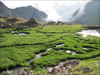
Headwater wetlands in the Sangre de Cristo Mountains of the
RGNF. |
effort to map and assess the condition of wetlands throughout the Rio Grande
Headwaters River Basin, which includes the RGNF. Existing paper maps of
wetlands created by the U.S. Fish and Wildlife Service (USFWS)’s National WetlandInventory (NWI) program were converted to digital data
by GIS Analysts at CPW. In
addition to the mapping, 137 wetlands were surveyed across the Rio Grande
Headwaters basin using condition assessment methods developed at CNHP over the
past decade. Of the wetlands surveyed, 52 were located on the RGNF in 10
different watersheds. To supplement the EPA-funded study, the U.S. ForestService (USFS) provided funding through a Challenge Cost Share Agreement for
additional wetland sampling on the RGNF to develop more comprehensive
information about the types, abundances, distribution, and condition of the
Forest’s wetlands. Through the agreement, 25 additional wetlands on the RGNF
were surveyed and all data from the RGNF were summarized.
 |
|
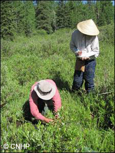
Field crew members sampling a fen wetlands on the RGNF.
|
facts about wetlands on the RGNF:
·
There are 42,862 acres of wetlands and water
bodies within the RGNF.
·
Lakes and rivers comprise 4,687 acres or 11%.
·
Wetlands and water bodies represents
approximately 2% of the total land area in the RGNF.
·
Slightly over half (55%) of NWI mapped acres are
freshwater herbaceous wetlands.
·
Shrub wetlands make up another 30%.
·
When broken down by hydrologic regime, saturated
wetlands are the most common, comprising 73% of NWI acres.
·
Within the RGNF, 82% of all lakes are mapped
with a dammed/impounded modifier, indicating that most lakes are reservoirs of
one kind or another.
·
Beavers influence only 4% of all wetland acres,
but 23% of ponds are mapped as beaver ponds and 6% of shrub wetlands are mapped
with beaver influence.
·
65% of all NWI acres occur in the subalpine
ecoregions, which make up roughly the same proportion of the Forest’s land
area.
·
Another 29% of NWI acres occur in the alpine
zone. Lower elevation zones contain very few wetland acres.
 |
|
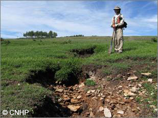
Down cutting of a small stream observed near a wetland in
the Rio de los Pinos watershed of the RGNF. |
Field surveys resulted in additional information about RGNF
wetlands.
·
In total, 77 wetland sites were surveyed across
the RGNF, including 30 riparian shrublands, 27 wet meadows, 17 fens, two
riparian woodlands, and one marsh.
·
Nearly 500 plant taxa were encountered during
the surveys, including 445 identified to the species level.
·
Of the 445 identified to species level, 420
(94%) were native species and 25 were non-native species.
·
Noxious weeds, an aggressive subset of
non-natives, were present in only four plots.
·
Wetland condition measures indicate that
wetlands on the RGNF are in excellent to good condition.
·
Floristic quality assessment indices were high
for most wetlands, though did vary by both elevation and wetland type.
·
Multi-metric Ecological Integrity Assessment
(EIA) scores rated most wetlands with an A- or B-rank, indicating that wetlands
were either in reference condition or deviated only slightly from reference
condition.
·
A handful of wetlands received C-ranks, due to
stressors including grazing, hydrologic modifications, and surrounding land
use.
quality wetlands that provide essential services to the Forest and lands
downstream. This study, in conjunction with others carried out by CNHP over the
past two decades, provides the RGNF with detailed information on specific
wetlands throughout the RGNF along with generalize conclusion on the extent,
distribution, and condition of wetlands. This information can be used for a
variety of management purposes.

