Colorado Natural Heritage Program Logo Colorado Natural Heritage Program Logo CNHP
  • About Us
    • About Us
      • Biennial Report
      • Strategic Plan
    • Conserving Biodiversity
    • Contact Us
    • Staff Directory
    • Careers
      • Employment
      • Internship
      • Volunteer
    • Meetings
    • The NatureServe Network
    • Partners
  • Our Work
    • Ecology
    • Wetlands
    • Plants
    • Animals
    • Climate Change
    • Education
    • Invasive Species
  • Our Services
    • Database Development
    • GIS Analysis & Modeling
    • Mapping
    • Surveys & Inventories
    • Monitoring & Assessment
    • Conservation Planning
  • Our Data
    • About CNHP Data
    • Request Data
    • Contribute Data
    • Download Data
    • Tracking Lists
    • PCA Reports
    • Help & Documentation
  • Maps
    • CNHP Spatial Layers
    • Wetlands Mapper
    • COMaP
    • Conservation Environmental Review Tool
  • Library
    • Reports
    • PCA Reports
    • Tracking Lists
    • Field Guides
      • Rare Plant Guide
      • Colorado Wetland Field Guides
  • Blog
  • Donate Now

Pop Quiz! Can you identify these anthropogenic disturbances from aerial photos?

November 7, 2012

Identifying anthropogenic disturbances from aerial photos can be tricky, but it is a regular feature of some of our work at CNHP. See if you can identify the disturbances by taking the quiz below. Answers at the bottom of the post.

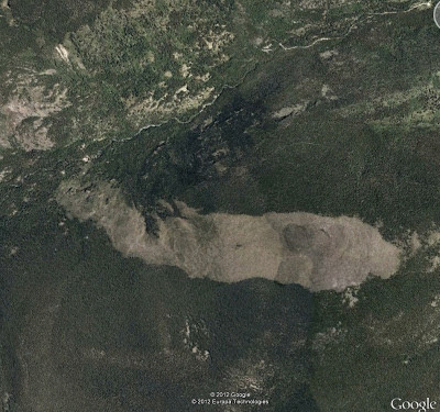
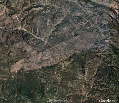
1. What caused the bald patches shown in these photos?

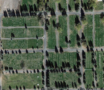
2. What are the white dots?

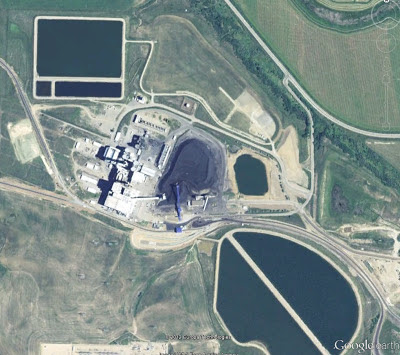
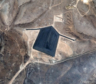
3. What is the dark smudge in the center of this photo? What about the black square and rectangles?

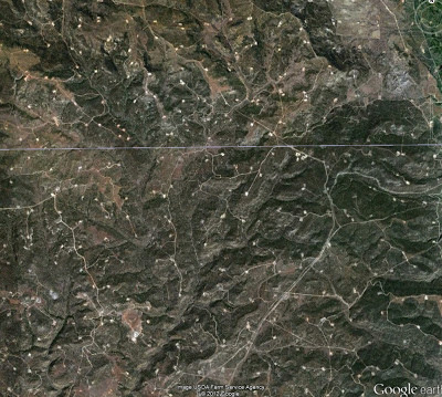
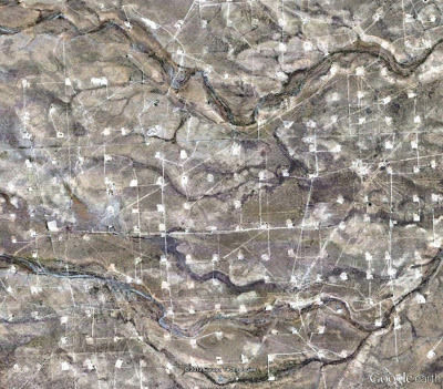
4. What causes the dense road patterns in both of these photos?

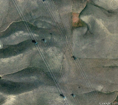
5. What are the diagonal lines shown here?

6. What are the rectangles in the middle of this photo? What about the circle and half-circle below?
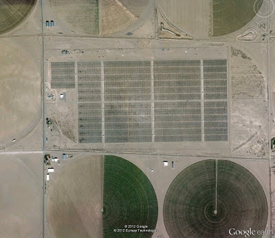
Bonus Question: how big are the circles?
 7.  What is the black object? Close up below.

Close up
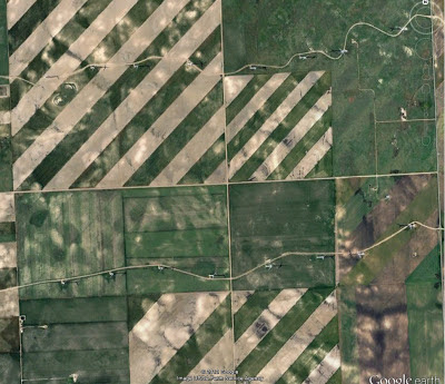
8. What causes the white and green diagonal stripe pattern? What are the white objects along the curvy roads?
Scroll down for the answers…
Quiz answers:
1. Both of the bald patches were caused by fires.  The top photo is the 1978 Ouzel fire in Rocky Mountain National Park and the bottom photo is the 1996 Buffalo Creek fire in Jefferson County.
2. Cemetery – the white dots are gravestones.
3. The dark smudge in the center of the photo is a heap of coal – this is a photo of the Hayden power plant in northwestern Colorado.  The black square and rectangles are ash ponds.
4. The dense road patterns are caused by oil and gas development.
5. Power lines.
6. A solar farm – the little rectangles are solar panels.  The circle and half-circle are crops irrigated by center pivot sprinklers. Bonus answer: each center-pivot system occupies a quarter of a section (a section is usually 1 square mile) so each circle has a diameter of about a half mile.
7. The black object is a uranium tailings “disposal cell” – the surface is covered with dark rocks.
8. In this farm field the green stripe is being farmed (dryland wheat) while the tan stripe lies fallow which allows the soil to regain nutrients.  The white objects along the curvy roads are wind turbines.

SHARE
FACEBOOK
TWITTER
LINKEDIN
REDDIT
EMAIL
Filed Under: Ecology

Mapped locations of rare and imperiled species and natural communities in CNHP’s database doubles in the past decade
National Park Service Projects 2012

About Us

About Us
Conserving Biodiversity
Contact Us
Staff Directory
Careers
Employment
Internship
Volunteer
Meetings
The NatureServe Network
Partners

Our Work

Ecology
Wetlands
Plants
Animals
Climate Change
Education
Invasive Species

Blog Archive

Blog Categories

Web Projects

  • Rare Plant Guide Online
  • Colorado Wetland Info Center
  • COMaP - Colorado Protected Lands
  • Colorado Bat Working Group
  • STReaMS - Endangered Fishes Database

About Us

  • About Us
  • Conserving Biodiversity
  • Contact Us
  • Staff Directory
  • Careers
  • The NatureServe Network
  • Partners
  • Site Map
Warner College of Natural Resources Logo
  • Apply to CSU
  • Equal Opportunity
  • Disclaimer
  • Privacy Statement
  • Search CSU
  • CSU Land Acknowledgement
  • CSU Principles of Community
© 2026 Colorado Natural Heritage Program
Colorado State University Logo
  • About Us
    ▼
    • About Us
      ▼
      • Biennial Report
      • Strategic Plan
    • Conserving Biodiversity
    • Contact Us
    • Staff Directory
    • Careers
      ▼
      • Employment
      • Internship
      • Volunteer
    • Meetings
    • The NatureServe Network
    • Partners
  • Our Work
    ▼
    • Ecology
    • Wetlands
    • Plants
    • Animals
    • Climate Change
    • Education
    • Invasive Species
  • Our Services
    ▼
    • Database Development
    • GIS Analysis & Modeling
    • Mapping
    • Surveys & Inventories
    • Monitoring & Assessment
    • Conservation Planning
  • Our Data
    ▼
    • About CNHP Data
    • Request Data
    • Contribute Data
    • Download Data
    • Tracking Lists
    • PCA Reports
    • Help & Documentation
  • Maps
    ▼
    • CNHP Spatial Layers
    • Wetlands Mapper
    • COMaP
    • Conservation Environmental Review Tool
  • Library
    ▼
    • Reports
    • PCA Reports
    • Tracking Lists
    • Field Guides
      ▼
      • Rare Plant Guide
      • Colorado Wetland Field Guides
  • Blog
  • Donate Now