Colorado Natural Heritage Program Logo Colorado Natural Heritage Program Logo CNHP
  • About Us
    • About Us
      • Biennial Report
      • Strategic Plan
    • Conserving Biodiversity
    • Contact Us
    • Staff Directory
    • Careers
      • Employment
      • Internship
      • Volunteer
    • Meetings
    • The NatureServe Network
    • Partners
  • Our Work
    • Ecology
    • Wetlands
    • Plants
    • Animals
    • Climate Change
    • Education
    • Invasive Species
  • Our Services
    • Database Development
    • GIS Analysis & Modeling
    • Mapping
    • Surveys & Inventories
    • Monitoring & Assessment
    • Conservation Planning
  • Our Data
    • About CNHP Data
    • Request Data
    • Contribute Data
    • Download Data
    • Tracking Lists
    • PCA Reports
    • Help & Documentation
  • Maps
    • CNHP Spatial Layers
    • Wetlands Mapper
    • COMaP
    • Conservation Environmental Review Tool
  • Library
    • Reports
    • PCA Reports
    • Tracking Lists
    • Field Guides
      • Rare Plant Guide
      • Colorado Wetland Field Guides
  • Blog
  • Donate Now

Ecosystems in the High Park fire area

September 20, 2012

The most common ecosystems in the High Park and Hewlett fire area are lower montane-foothill shrubland, ponderosa pine woodland, mixed conifer forest, and lodgepole pine forest.

Many square miles of these shrubland, woodland, and forest ecosystems were burned during the May and June fires. In August, LightHawk volunteer pilot Dan Evans flew CNHP’s Michael Menefee, Jill Handwerk, and Dave Anderson over the area. Although it was hazy, they were able to take many excellent photos of the burn effects. 

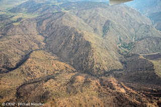
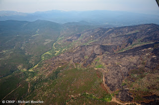
The view down the Poudre Canyon (at right) at its junction with Cedar Gulch (left). Slopes are mostly foothills shrubland dominated by mountain mahogany. Burned stands of mixed conifer are on north-facing slopes.

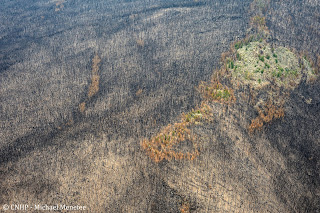
Closer view of burned mountain mahogany (gray circles) against a background of green grass and forbs. It doesn’t look too bad from up here. The shrubs will resprout after being burned.

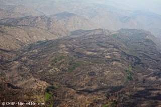
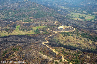
Burn mosaic of ponderosa pine and mixed conifer in the Bear Mountain area, south of the Cache la Poudre River. View is to the north toward the Narrows and Sheep Mountain beyond.
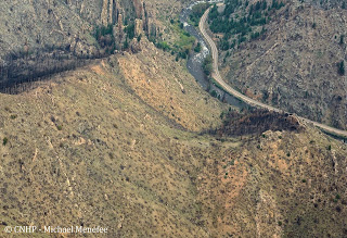
Fire edge at Pingree Road. Burned ponderosa woodland to the left, unburned woodland to the right.

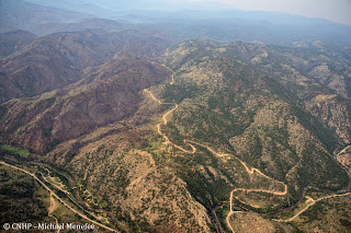
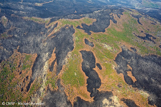
Ponderosa burn mosaic at Buckhorn Mountain.

Fire boundary at Buckhorn Road. Burned lodgepole to the right, unburned to the left. There are many beetle-killed trees still standing in the unburned area.
Lodgepole burn mosaic, vicinity of West White Pine Mountain.
A closer view of burned lodgepole forest.

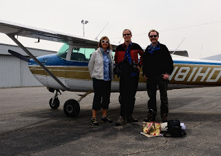
Jill, Michael, and Dave back on the ground after the flight.

Many thanks to Dan and LightHawk. Stay tuned for more High Park fire photos.

SHARE
FACEBOOK
TWITTER
LINKEDIN
REDDIT
EMAIL
Filed Under: Collaborations, Fire

CNHP director stars in Mt. Evans video
Erosion in the High Park fire area

About Us

About Us
Conserving Biodiversity
Contact Us
Staff Directory
Careers
Employment
Internship
Volunteer
Meetings
The NatureServe Network
Partners

Our Work

Ecology
Wetlands
Plants
Animals
Climate Change
Education
Invasive Species

Blog Archive

Blog Categories

Web Projects

  • Rare Plant Guide Online
  • Colorado Wetland Info Center
  • COMaP - Colorado Protected Lands
  • Colorado Bat Working Group
  • STReaMS - Endangered Fishes Database

About Us

  • About Us
  • Conserving Biodiversity
  • Contact Us
  • Staff Directory
  • Careers
  • The NatureServe Network
  • Partners
  • Site Map
Warner College of Natural Resources Logo
  • Apply to CSU
  • Equal Opportunity
  • Disclaimer
  • Privacy Statement
  • Search CSU
  • CSU Land Acknowledgement
  • CSU Principles of Community
© 2026 Colorado Natural Heritage Program
Colorado State University Logo
  • About Us
    ▼
    • About Us
      ▼
      • Biennial Report
      • Strategic Plan
    • Conserving Biodiversity
    • Contact Us
    • Staff Directory
    • Careers
      ▼
      • Employment
      • Internship
      • Volunteer
    • Meetings
    • The NatureServe Network
    • Partners
  • Our Work
    ▼
    • Ecology
    • Wetlands
    • Plants
    • Animals
    • Climate Change
    • Education
    • Invasive Species
  • Our Services
    ▼
    • Database Development
    • GIS Analysis & Modeling
    • Mapping
    • Surveys & Inventories
    • Monitoring & Assessment
    • Conservation Planning
  • Our Data
    ▼
    • About CNHP Data
    • Request Data
    • Contribute Data
    • Download Data
    • Tracking Lists
    • PCA Reports
    • Help & Documentation
  • Maps
    ▼
    • CNHP Spatial Layers
    • Wetlands Mapper
    • COMaP
    • Conservation Environmental Review Tool
  • Library
    ▼
    • Reports
    • PCA Reports
    • Tracking Lists
    • Field Guides
      ▼
      • Rare Plant Guide
      • Colorado Wetland Field Guides
  • Blog
  • Donate Now