Colorado Natural Heritage Program Logo Colorado Natural Heritage Program Logo CNHP
  • About Us
    • About Us
      • Biennial Report
      • Strategic Plan
    • Conserving Biodiversity
    • Contact Us
    • Staff Directory
    • Careers
      • Employment
      • Internship
      • Volunteer
    • Meetings
    • The NatureServe Network
    • Partners
  • Our Work
    • Ecology
    • Wetlands
    • Plants
    • Animals
    • Climate Change
    • Education
    • Invasive Species
  • Our Services
    • Database Development
    • GIS Analysis & Modeling
    • Mapping
    • Surveys & Inventories
    • Monitoring & Assessment
    • Conservation Planning
  • Our Data
    • About CNHP Data
    • Request Data
    • Contribute Data
    • Download Data
    • Tracking Lists
    • PCA Reports
    • Help & Documentation
  • Maps
    • CNHP Spatial Layers
    • Wetlands Mapper
    • COMaP
    • Conservation Environmental Review Tool
  • Library
    • Reports
    • PCA Reports
    • Tracking Lists
    • Field Guides
      • Rare Plant Guide
      • Colorado Wetland Field Guides
  • Blog
  • Donate Now

Biodiversity in the High Park burn area

September 7, 2012

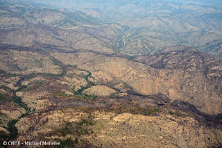
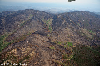
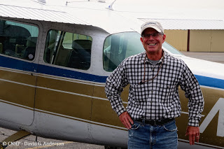
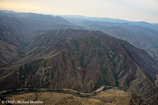
Between the Hewlett fire in May, and the High Park fire in June, nearly 95,000 acres of Larimer County felt the effects of wildland fire in 2012.  Thanks to LightHawk volunteer pilot Dan Evans, CNHP’s Dave Anderson, Jill Handwerk, and Michael Menefee were able to fly over the burn area and check out the impacts to some of the elements of biodiversity that CNHP has documented over the years.

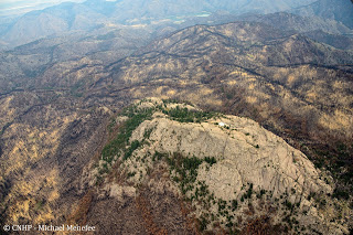
The Larimer aletes (Aletes humilis) is endemic to the Colorado Front Range, where it thrives in the shallow, gravelly surface soils around rock outcrops, such as are found at Gray Rock in the Hewlett burn area.

Larimer aletes habitat at Gray Rock – some burned, and some escaped – we don’t know about the plants themselves yet.

The Arapaho stonefly is known only from two tributaries to the Cache la Poudre River: Elkhorn Creek and Young Gulch (where it has not been seen since 1986).

Young Gulch on the left was in the burned area (Mishawaka is visible in the lower right).

Fortunately, Elk Creek (center, above) was just outside the burn area – a narrow escape for the little stonefly!

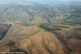
The High Park burn area is also home to a variety of plant communities that are typical of this part of the Colorado Front Range.

Slopes above the South Fork of the Poudre as it winds its way south of Mt. McConnel were once covered by a ponderosa pine savaana with grassy understory, or by dense stands of mixed conifer in wetter places.

On the south side of East and West White Pine Mountains, riparian areas of thinleaf alder and mesic graminoids are still largely green, while the surrounding lodgepole forest has burned black. The Buckhorn Road and edge of burn are visible in the lower right.

Thanks again to LightHawk and Dan!

Stay tuned for more photos from the High Park burn.

SHARE
FACEBOOK
TWITTER
LINKEDIN
REDDIT
EMAIL
Filed Under: Collaborations, Fire

Erosion in the High Park fire area
Job Opening: Wetland Mapping Specialist

About Us

About Us
Conserving Biodiversity
Contact Us
Staff Directory
Careers
Employment
Internship
Volunteer
Meetings
The NatureServe Network
Partners

Our Work

Ecology
Wetlands
Plants
Animals
Climate Change
Education
Invasive Species

Blog Archive

Blog Categories

Web Projects

  • Rare Plant Guide Online
  • Colorado Wetland Info Center
  • COMaP - Colorado Protected Lands
  • Colorado Bat Working Group
  • STReaMS - Endangered Fishes Database

About Us

  • About Us
  • Conserving Biodiversity
  • Contact Us
  • Staff Directory
  • Careers
  • The NatureServe Network
  • Partners
  • Site Map
Warner College of Natural Resources Logo
  • Apply to CSU
  • Equal Opportunity
  • Disclaimer
  • Privacy Statement
  • Search CSU
  • CSU Land Acknowledgement
  • CSU Principles of Community
© 2026 Colorado Natural Heritage Program
Colorado State University Logo
  • About Us
    ▼
    • About Us
      ▼
      • Biennial Report
      • Strategic Plan
    • Conserving Biodiversity
    • Contact Us
    • Staff Directory
    • Careers
      ▼
      • Employment
      • Internship
      • Volunteer
    • Meetings
    • The NatureServe Network
    • Partners
  • Our Work
    ▼
    • Ecology
    • Wetlands
    • Plants
    • Animals
    • Climate Change
    • Education
    • Invasive Species
  • Our Services
    ▼
    • Database Development
    • GIS Analysis & Modeling
    • Mapping
    • Surveys & Inventories
    • Monitoring & Assessment
    • Conservation Planning
  • Our Data
    ▼
    • About CNHP Data
    • Request Data
    • Contribute Data
    • Download Data
    • Tracking Lists
    • PCA Reports
    • Help & Documentation
  • Maps
    ▼
    • CNHP Spatial Layers
    • Wetlands Mapper
    • COMaP
    • Conservation Environmental Review Tool
  • Library
    ▼
    • Reports
    • PCA Reports
    • Tracking Lists
    • Field Guides
      ▼
      • Rare Plant Guide
      • Colorado Wetland Field Guides
  • Blog
  • Donate Now