Colorado Natural Heritage Program Logo Colorado Natural Heritage Program Logo CNHP
  • About Us
    • About Us
      • Biennial Report
      • Strategic Plan
    • Conserving Biodiversity
    • Contact Us
    • Staff Directory
    • Careers
      • Employment
      • Internship
      • Volunteer
    • Meetings
    • The NatureServe Network
    • Partners
  • Our Work
    • Ecology
    • Wetlands
    • Plants
    • Animals
    • Climate Change
    • Education
    • Invasive Species
  • Our Services
    • Database Development
    • GIS Analysis & Modeling
    • Mapping
    • Surveys & Inventories
    • Monitoring & Assessment
    • Conservation Planning
  • Our Data
    • About CNHP Data
    • Request Data
    • Contribute Data
    • Download Data
    • Tracking Lists
    • PCA Reports
    • Help & Documentation
  • Maps
    • CNHP Spatial Layers
    • Wetlands Mapper
    • COMaP
    • Conservation Environmental Review Tool
  • Library
    • Reports
    • PCA Reports
    • Tracking Lists
    • Field Guides
      • Rare Plant Guide
      • Colorado Wetland Field Guides
  • Blog
  • Donate Now

Southern Colorado Landscapes: Part 2

July 12, 2012

During a June flight with Lighthawk volunteer pilot Steve Paul, CNHP’s Renée Rondeau got a tour of many of the ecosystems in the southern Colorado (Part 1, the San Luis Valley).

The Sangre de Cristo Mountains

The Sangre de Cristos are a steep, narrow mountain range along the eastern boundary of the San Luis Valley. The prominent massif of Blanca Peak anchors the central part of the range. Further south, the southern Sangre de Cristos are called the Culebra Range, and form the western boundary of the Park Plateau in northern New Mexico.

These mountains support narrow bands of shrubland, woodland, and forest types with increasing elevation, and include alpine and barren rock habitats at the highest elevations.

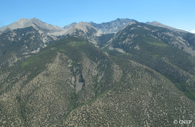
Slopes below Blanca Peak illustrate how vegetation types change with elevation in the Sangre de Cristos, from pinyon-juniper at the bottom to alpine at the top.

Above the pinyon-juniper, stands of aspen and mixed conifer dominate.

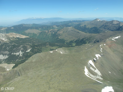
Near Whiskey Pass, spruce-fir forest clusters below the alpine tundra.
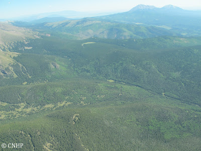
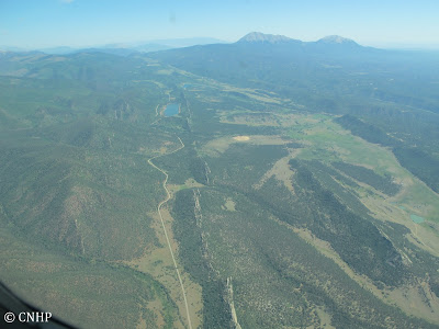
Second verse, same as the first. Once over the mountain ridge, on the east side of the Sangre de Cristos, we head back down through the different forest types. The Spanish Peaks are visible in the upper right.

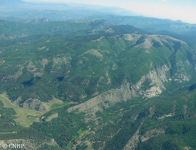
Back down at the pinyon-juniper. The view north along the Stonewall, a volcanic dike that goes on for nearly 30 miles.
More to come in part 3, as Renée and Steve venture into northern New Mexico.

SHARE
FACEBOOK
TWITTER
LINKEDIN
REDDIT
EMAIL
Filed Under: Collaborations, Ecology

Southern Colorado (and northern New Mexico) Landscapes: Part 3
Southern Colorado Landscapes: Part 1

About Us

About Us
Conserving Biodiversity
Contact Us
Staff Directory
Careers
Employment
Internship
Volunteer
Meetings
The NatureServe Network
Partners

Our Work

Ecology
Wetlands
Plants
Animals
Climate Change
Education
Invasive Species

Blog Archive

Blog Categories

Web Projects

  • Rare Plant Guide Online
  • Colorado Wetland Info Center
  • COMaP - Colorado Protected Lands
  • Colorado Bat Working Group
  • STReaMS - Endangered Fishes Database

About Us

  • About Us
  • Conserving Biodiversity
  • Contact Us
  • Staff Directory
  • Careers
  • The NatureServe Network
  • Partners
  • Site Map
Warner College of Natural Resources Logo
  • Apply to CSU
  • Equal Opportunity
  • Disclaimer
  • Privacy Statement
  • Search CSU
  • CSU Land Acknowledgement
  • CSU Principles of Community
© 2026 Colorado Natural Heritage Program
Colorado State University Logo
  • About Us
    ▼
    • About Us
      ▼
      • Biennial Report
      • Strategic Plan
    • Conserving Biodiversity
    • Contact Us
    • Staff Directory
    • Careers
      ▼
      • Employment
      • Internship
      • Volunteer
    • Meetings
    • The NatureServe Network
    • Partners
  • Our Work
    ▼
    • Ecology
    • Wetlands
    • Plants
    • Animals
    • Climate Change
    • Education
    • Invasive Species
  • Our Services
    ▼
    • Database Development
    • GIS Analysis & Modeling
    • Mapping
    • Surveys & Inventories
    • Monitoring & Assessment
    • Conservation Planning
  • Our Data
    ▼
    • About CNHP Data
    • Request Data
    • Contribute Data
    • Download Data
    • Tracking Lists
    • PCA Reports
    • Help & Documentation
  • Maps
    ▼
    • CNHP Spatial Layers
    • Wetlands Mapper
    • COMaP
    • Conservation Environmental Review Tool
  • Library
    ▼
    • Reports
    • PCA Reports
    • Tracking Lists
    • Field Guides
      ▼
      • Rare Plant Guide
      • Colorado Wetland Field Guides
  • Blog
  • Donate Now