Colorado Natural Heritage Program Logo Colorado Natural Heritage Program Logo CNHP
  • About Us
    • About Us
      • Biennial Report
      • Strategic Plan
    • Conserving Biodiversity
    • Contact Us
    • Staff Directory
    • Careers
      • Employment
      • Internship
      • Volunteer
    • Meetings
    • The NatureServe Network
    • Partners
  • Our Work
    • Ecology
    • Wetlands
    • Plants
    • Animals
    • Climate Change
    • Education
    • Invasive Species
  • Our Services
    • Database Development
    • GIS Analysis & Modeling
    • Mapping
    • Surveys & Inventories
    • Monitoring & Assessment
    • Conservation Planning
  • Our Data
    • About CNHP Data
    • Request Data
    • Contribute Data
    • Download Data
    • Tracking Lists
    • PCA Reports
    • Help & Documentation
  • Maps
    • CNHP Spatial Layers
    • Wetlands Mapper
    • COMaP
    • Conservation Environmental Review Tool
  • Library
    • Reports
    • PCA Reports
    • Tracking Lists
    • Field Guides
      • Rare Plant Guide
      • Colorado Wetland Field Guides
  • Blog
  • Donate Now

Southern Colorado Landscapes: Part 1

July 10, 2012

Last month Renée Rondeau had the opportunity to make an overflight of the San Luis Valley, southern Sangre de Cristo Mountains and the Park Plateau in northern New Mexico. Thanks to Lighthawk volunteer pilot Steve Paul, Renée got a birds-eye view of the diversity of ecosystems in the area.

The floodplain of the Rio Grande in the San Luis Valley, with Blanca Peak in the distance.

The San Luis Valley

Although much of the San Luis Valley floor is devoted to irrigated agriculture, the eastern portion is still dominated by native vegetation. The northern end of the San Luis Valley has no natural hydrological connection to the southern end, which is drained by the Rio Grande River and its tributaries. This “closed basin” is home to the Great Sand Dunes National Park and Preserve, where the dune field and the surrounding sandsheet shrublands and sabkha wetlands form a sparsely vegetated landscape along the eastern edge of the valley.
Great Sand Dunes National Park and Preserve
Medano Creek flowing along the edge of the dunes, where it disappears into the sand.

Great Sand Dunes National Park and Preserve
The dune field, with the Sangre de Cristo Mountains in the background.

Great Sand Dunes National Park and Preserve
A rolling dune gathers no moss (or other vegetation), but parts of the Great Sand Dunes have stayed still long enough to become partially vegetated. Here we see a view of the sandsheet shrublands, west of the dune field.

sabkha wetlands
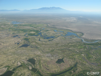
Sabkha wetlands at the “sump” – the bottom end of the closed basin.

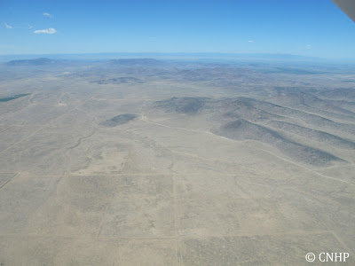
Semi-desert shrub-steppe and the San Luis Hills.
Stay tuned for more in part 2 – when we fly over the southern Sangre de Cristo Mountains.


SHARE
FACEBOOK
TWITTER
LINKEDIN
REDDIT
EMAIL
Filed Under: Collaborations, Ecology, National Parks

Southern Colorado Landscapes: Part 2
Happy Independence Day!

About Us

About Us
Conserving Biodiversity
Contact Us
Staff Directory
Careers
Employment
Internship
Volunteer
Meetings
The NatureServe Network
Partners

Our Work

Ecology
Wetlands
Plants
Animals
Climate Change
Education
Invasive Species

Blog Archive

Blog Categories

Web Projects

  • Rare Plant Guide Online
  • Colorado Wetland Info Center
  • COMaP - Colorado Protected Lands
  • Colorado Bat Working Group
  • STReaMS - Endangered Fishes Database

About Us

  • About Us
  • Conserving Biodiversity
  • Contact Us
  • Staff Directory
  • Careers
  • The NatureServe Network
  • Partners
  • Site Map
Warner College of Natural Resources Logo
  • Apply to CSU
  • Equal Opportunity
  • Disclaimer
  • Privacy Statement
  • Search CSU
  • CSU Land Acknowledgement
  • CSU Principles of Community
© 2026 Colorado Natural Heritage Program
Colorado State University Logo
  • About Us
    ▼
    • About Us
      ▼
      • Biennial Report
      • Strategic Plan
    • Conserving Biodiversity
    • Contact Us
    • Staff Directory
    • Careers
      ▼
      • Employment
      • Internship
      • Volunteer
    • Meetings
    • The NatureServe Network
    • Partners
  • Our Work
    ▼
    • Ecology
    • Wetlands
    • Plants
    • Animals
    • Climate Change
    • Education
    • Invasive Species
  • Our Services
    ▼
    • Database Development
    • GIS Analysis & Modeling
    • Mapping
    • Surveys & Inventories
    • Monitoring & Assessment
    • Conservation Planning
  • Our Data
    ▼
    • About CNHP Data
    • Request Data
    • Contribute Data
    • Download Data
    • Tracking Lists
    • PCA Reports
    • Help & Documentation
  • Maps
    ▼
    • CNHP Spatial Layers
    • Wetlands Mapper
    • COMaP
    • Conservation Environmental Review Tool
  • Library
    ▼
    • Reports
    • PCA Reports
    • Tracking Lists
    • Field Guides
      ▼
      • Rare Plant Guide
      • Colorado Wetland Field Guides
  • Blog
  • Donate Now