Colorado Natural Heritage Program Logo Colorado Natural Heritage Program Logo CNHP
  • About Us
    • About Us
      • Biennial Report
      • Strategic Plan
    • Conserving Biodiversity
    • Contact Us
    • Staff Directory
    • Careers
      • Employment
      • Internship
      • Volunteer
    • Meetings
    • The NatureServe Network
    • Partners
  • Our Work
    • Ecology
    • Wetlands
    • Plants
    • Animals
    • Climate Change
    • Education
    • Invasive Species
  • Our Services
    • Database Development
    • GIS Analysis & Modeling
    • Mapping
    • Surveys & Inventories
    • Monitoring & Assessment
    • Conservation Planning
  • Our Data
    • About CNHP Data
    • Request Data
    • Contribute Data
    • Download Data
    • Tracking Lists
    • PCA Reports
    • Help & Documentation
  • Maps
    • CNHP Spatial Layers
    • Wetlands Mapper
    • COMaP
    • Conservation Environmental Review Tool
  • Library
    • Reports
    • PCA Reports
    • Tracking Lists
    • Field Guides
      • Rare Plant Guide
      • Colorado Wetland Field Guides
  • Blog
  • Donate Now

Field Trip to Columbia Gorge with WNHP

May 9, 2012

by Kirstin Holfelder, Database Developer and Assistant Database Administrator

As an ecologist turned data manager, I was particularly looking forward to getting out during the field trips that kicked off the 2012 Biodiversity without Boundaries meeting. There’s nothing more fun than hiking with botanists, ornithologists, and entomologists; people who are passionate about their science. You may only cover a half a mile of ground every two hours, but you will know that half mile very well.

Washington NHP director John Gammon and Robin Dobson, an ecologist who helped establish the Columbia River Gorge National Scenic Area, co-lead a trip that started in the lush forests of the Cascade Range’s western slope and travelled up the Columbia Gorge to the drier eastern side. We couldn’t have had more knowledgeable guides to the cultural and natural history of the area.

Temperate rain forest on the western side of the Cascade range (photo by Kirstin Holfelder)

The Columbia Gorge is a canyon that marks the state line between Washington and Oregon. It was formed largely during the last ice age by the Missoula Floods. It seems there was a glacial lake up there in Montana that periodically broke through its ice dam to release the epic quantities of water required to carve a gorge 80 miles long and 4000 feet deep. The unique geological history is echoed by the biodiversity of the area. Temperate rainforests transition to dry woodlands, then to grasslands as you travel east along a decreasing rainfall gradient. We ended our day in ponderosa pine meadows that bear a striking resemblance to Colorado’s Front Range.

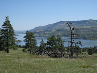
Ponderosa pine meadow, looking east towards the dry grasslands of the Columbia Plateau (photo by Kirstin Holfelder)

Late April is a wonderful time to visit, because many of the wildflowers are blooming. I admit I may have contributed to the slow pace of the hike by stopping to take half a dozen pictures of each. My favorite by far was death camas (Zigadenus venenosus). It is a poisonous plant that looks unfortunately similar to members of the edible Camassia genus when not in flower. The Camassias were a staple food source for Native Americans in the area, so it’s not hard to see how death camas got its name.

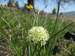
Death camas in a field of wild flowers (photo by Kirstin Holfelder)

Throughout the field trip, Robin and John talked about the collaboration between scientists, land owners, and interest groups that made the creation and management of the scenic area possible. As I strolled through wildflowers and observed endangered western pond turtles, I got to personally experience how amazing the results of such cooperation can be. When interested people committed to working together make informed decisions, it’s truly amazing what we can accomplish.

SHARE
FACEBOOK
TWITTER
LINKEDIN
REDDIT
EMAIL
Filed Under: Botany, Conferences, Ecology, Threatened and Endangered Species

Field Botanists Wanted!
Congratulations to the Washington Natural Heritage Program

About Us

About Us
Conserving Biodiversity
Contact Us
Staff Directory
Careers
Employment
Internship
Volunteer
Meetings
The NatureServe Network
Partners

Our Work

Ecology
Wetlands
Plants
Animals
Climate Change
Education
Invasive Species

Blog Archive

Blog Categories

Web Projects

  • Rare Plant Guide Online
  • Colorado Wetland Info Center
  • COMaP - Colorado Protected Lands
  • Colorado Bat Working Group
  • STReaMS - Endangered Fishes Database

About Us

  • About Us
  • Conserving Biodiversity
  • Contact Us
  • Staff Directory
  • Careers
  • The NatureServe Network
  • Partners
  • Site Map
Warner College of Natural Resources Logo
  • Apply to CSU
  • Equal Opportunity
  • Disclaimer
  • Privacy Statement
  • Search CSU
  • CSU Land Acknowledgement
  • CSU Principles of Community
© 2026 Colorado Natural Heritage Program
Colorado State University Logo
  • About Us
    ▼
    • About Us
      ▼
      • Biennial Report
      • Strategic Plan
    • Conserving Biodiversity
    • Contact Us
    • Staff Directory
    • Careers
      ▼
      • Employment
      • Internship
      • Volunteer
    • Meetings
    • The NatureServe Network
    • Partners
  • Our Work
    ▼
    • Ecology
    • Wetlands
    • Plants
    • Animals
    • Climate Change
    • Education
    • Invasive Species
  • Our Services
    ▼
    • Database Development
    • GIS Analysis & Modeling
    • Mapping
    • Surveys & Inventories
    • Monitoring & Assessment
    • Conservation Planning
  • Our Data
    ▼
    • About CNHP Data
    • Request Data
    • Contribute Data
    • Download Data
    • Tracking Lists
    • PCA Reports
    • Help & Documentation
  • Maps
    ▼
    • CNHP Spatial Layers
    • Wetlands Mapper
    • COMaP
    • Conservation Environmental Review Tool
  • Library
    ▼
    • Reports
    • PCA Reports
    • Tracking Lists
    • Field Guides
      ▼
      • Rare Plant Guide
      • Colorado Wetland Field Guides
  • Blog
  • Donate Now