Colorado Natural Heritage Program Logo Colorado Natural Heritage Program Logo CNHP
  • About Us
    • About Us
      • Biennial Report
      • Strategic Plan
    • Conserving Biodiversity
    • Contact Us
    • Staff Directory
    • Careers
      • Employment
      • Internship
      • Volunteer
    • Meetings
    • The NatureServe Network
    • Partners
  • Our Work
    • Ecology
    • Wetlands
    • Plants
    • Animals
    • Climate Change
    • Education
    • Invasive Species
  • Our Services
    • Database Development
    • GIS Analysis & Modeling
    • Mapping
    • Surveys & Inventories
    • Monitoring & Assessment
    • Conservation Planning
  • Our Data
    • About CNHP Data
    • Request Data
    • Contribute Data
    • Download Data
    • Tracking Lists
    • PCA Reports
    • Help & Documentation
  • Maps
    • CNHP Spatial Layers
    • Wetlands Mapper
    • COMaP
    • Conservation Environmental Review Tool
  • Library
    • Reports
    • PCA Reports
    • Tracking Lists
    • Field Guides
      • Rare Plant Guide
      • Colorado Wetland Field Guides
  • Blog
  • Donate Now

2011 Wetland Condition Assessments – Successfully Profiling a Broad Range of Wetland Conditions

December 8, 2011

by Laurie Gilligan

During the 2011 field season, crews from CNHP Ecology Team successfully conducted 82 wetland condition assessment surveys in three project areas for three different objectives:
  1. 34 wetlands were assessed in the northern Front Range to inform wetland mitigation decisions along the Front Range corridor,
  2. 17 wetlands were assessed in western Routt National Forest for targeted monitoring and resampling of riparian wetlands, and
  3. 31 wetlands were assessed throughout Colorado and Wyoming as part of the first National Wetland Condition Assessment.
These assessments included detailed vegetation surveys to calculate a floristic quality index and an assessment of each site’s landscape context, physiochemistry, and hydrologic integrity. The 2011 surveys spanned a wide range of wetland types and condition. The results will be compiled into reports to inform land managers and other stakeholders about the condition of their valued aquatic resources, leading to more effective conservation and management.
A typical site in the Front Range was located adjacent to urban influences, such as oil and gas well platforms, center-pivot irrigation crop fields, or along reservoir shores within suburban housing developments. Nearly one-half (15 of 34) of the wetlands surveyed using a randomized study design were dominated by cattail species (Typha latifolia and/or T. angustifolia). Noxious species were recorded in all but two of the wetlands surveyed. Dominance of cattail is indicative of high nutrient conditions, but wetlands are valued for their ability to filter and reduce nutrient loads before polluted runoff waters from urban areas return to Colorado’s rivers. These wetlands were hard-working!

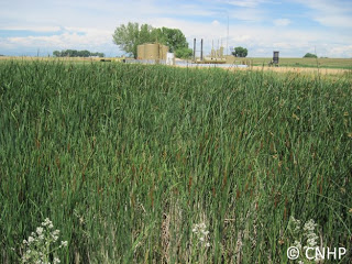
A marsh wetland in Weld County, Colorado.
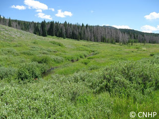
In contrast, a number of the wetlands surveyed in the Routt National Forest and National Wetland Condition Assessment projects were riparian shrublands supporting plants indicative of higher ecological integrity. As a wetland contains higher species diversity, greater vertical structure, and more native plant species, the wetlands themselves can support more diverse wildlife habitat. As an example, the Grizzly Creek Park site (shown below) was a mosaic of Wolf’s willow (Salix wolfii) interspersed with hillside seeps (the brightest green areas) dominated by mixed sedge (Carex) species. These wetlands were prioritized for survey in part to record baseline data near beetle-killed forests that may be logged in the future.
 

A riparian shrubland wetland site from Grizzly Creek Park in Routt National Forest.

SHARE
FACEBOOK
TWITTER
LINKEDIN
REDDIT
EMAIL
Filed Under: Ecology, Wetlands

Botany A to Z: Brassicaceae
Botany A to Z: Astragalus

About Us

About Us
Conserving Biodiversity
Contact Us
Staff Directory
Careers
Employment
Internship
Volunteer
Meetings
The NatureServe Network
Partners

Our Work

Ecology
Wetlands
Plants
Animals
Climate Change
Education
Invasive Species

Blog Archive

Blog Categories

Web Projects

  • Rare Plant Guide Online
  • Colorado Wetland Info Center
  • COMaP - Colorado Protected Lands
  • Colorado Bat Working Group
  • STReaMS - Endangered Fishes Database

About Us

  • About Us
  • Conserving Biodiversity
  • Contact Us
  • Staff Directory
  • Careers
  • The NatureServe Network
  • Partners
  • Site Map
Warner College of Natural Resources Logo
  • Apply to CSU
  • Equal Opportunity
  • Disclaimer
  • Privacy Statement
  • Search CSU
  • CSU Land Acknowledgement
  • CSU Principles of Community
© 2026 Colorado Natural Heritage Program
Colorado State University Logo
  • About Us
    ▼
    • About Us
      ▼
      • Biennial Report
      • Strategic Plan
    • Conserving Biodiversity
    • Contact Us
    • Staff Directory
    • Careers
      ▼
      • Employment
      • Internship
      • Volunteer
    • Meetings
    • The NatureServe Network
    • Partners
  • Our Work
    ▼
    • Ecology
    • Wetlands
    • Plants
    • Animals
    • Climate Change
    • Education
    • Invasive Species
  • Our Services
    ▼
    • Database Development
    • GIS Analysis & Modeling
    • Mapping
    • Surveys & Inventories
    • Monitoring & Assessment
    • Conservation Planning
  • Our Data
    ▼
    • About CNHP Data
    • Request Data
    • Contribute Data
    • Download Data
    • Tracking Lists
    • PCA Reports
    • Help & Documentation
  • Maps
    ▼
    • CNHP Spatial Layers
    • Wetlands Mapper
    • COMaP
    • Conservation Environmental Review Tool
  • Library
    ▼
    • Reports
    • PCA Reports
    • Tracking Lists
    • Field Guides
      ▼
      • Rare Plant Guide
      • Colorado Wetland Field Guides
  • Blog
  • Donate Now