Colorado Natural Heritage Program Logo Colorado Natural Heritage Program Logo CNHP
  • About Us
    • About Us
      • Biennial Report
      • Strategic Plan
    • Conserving Biodiversity
    • Contact Us
    • Staff Directory
    • Careers
      • Employment
      • Internship
      • Volunteer
    • Meetings
    • The NatureServe Network
    • Partners
  • Our Work
    • Ecology
    • Wetlands
    • Plants
    • Animals
    • Climate Change
    • Education
    • Invasive Species
  • Our Services
    • Database Development
    • GIS Analysis & Modeling
    • Mapping
    • Surveys & Inventories
    • Monitoring & Assessment
    • Conservation Planning
  • Our Data
    • About CNHP Data
    • Request Data
    • Contribute Data
    • Download Data
    • Tracking Lists
    • PCA Reports
    • Help & Documentation
  • Maps
    • CNHP Spatial Layers
    • Wetlands Mapper
    • COMaP
    • Conservation Environmental Review Tool
  • Library
    • Reports
    • PCA Reports
    • Tracking Lists
    • Field Guides
      • Rare Plant Guide
      • Colorado Wetland Field Guides
  • Blog
  • Donate Now

Ecological systems: Grasslands

August 2, 2011

Grasslands other than those of the Shortgrass Prairie in Colorado can be classified into three major groups: Western Great Plains Foothill and Piedmont Grassland, Southern Rocky Mountain Montane-Subalpine Grassland, and Inter-Mountain Basins Semi-Desert Grassland. Together these grasslands types cover about three million acres in our state.
Foothill and piedmont grasslands are found at the extreme western edge of the Great Plains, where increasing elevation and precipitation facilitate the development of mixed to tallgrass associations on certain soils. These grasslands typically occur at elevations between 5,250 and 7,200 ft. Typical species include big bluestem, little bluestem, needle-and-thread. 
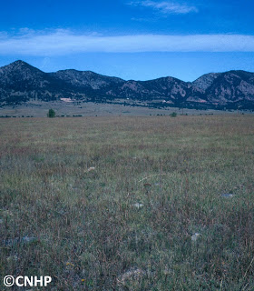
 Foothill-piedmont grassland – Rocky Flats area.
Montane-subalpine grasslands in the Colorado Rockies are found at elevations of 7,200-10,000 feet, intermixed with stands of spruce-fir, lodgepole, ponderosa, and aspen forests, or as the matrix community in the large intermountain basin of South Park. Lower elevation montane grasslands are more xeric, while upper montane or subalpine grasslands are more mesic. Typical species include fescue, muhly, oatgrass, and others. 
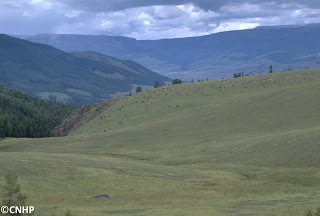
Montane grassland – Mineral County
Colorado’s semi-desert grasslands are found primarily on dry plains and mesas of the west slope at elevations of 4,750-7,600 feet. These grasslands are typically dominated by drought-resistant perennial bunch grasses such as bluebunch wheatgrass, blue grama, galleta grass, and needle-and-thread, and may include scattered shrubs.
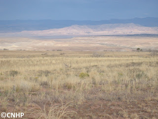
 Semi-desert grassland – Mesa County
Common species characteristic of these grasslands include the vesper sparrow, mountain bluebird, Brewer’s blackbird, and white-tailed jack rabbit. Rarer species are the Gunnison’s prairie dog and a variety of skipper butterflies. Impacts from human activity other than domestic livestock grazing are low for most of these grasslands, although a significant portion of historic occurrances have been lost through habitat conversion. The majority of Colorado’s grassland acreage is on privately owned lands, although much of the montane grasslands are on federal land managed by the USFS or the BLM. Although many of our remaining occurrences are in good condition, protection for these grasslands is generally lacking. 
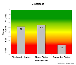
Overall biodiversity, threat, and protection status scores for grasslands in Colorado.
 
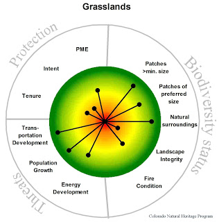
A “windrose” graph depicting grassland status for individual scoring factors.

SHARE
FACEBOOK
TWITTER
LINKEDIN
REDDIT
EMAIL
Filed Under: Biodiversity Scorecard, Conservation Planning, Ecology

RMBO BBQ for the Birds August 27
GLORIA Project: Yellowstone National Park

About Us

About Us
Conserving Biodiversity
Contact Us
Staff Directory
Careers
Employment
Internship
Volunteer
Meetings
The NatureServe Network
Partners

Our Work

Ecology
Wetlands
Plants
Animals
Climate Change
Education
Invasive Species

Blog Archive

Blog Categories

Web Projects

  • Rare Plant Guide Online
  • Colorado Wetland Info Center
  • COMaP - Colorado Protected Lands
  • Colorado Bat Working Group
  • STReaMS - Endangered Fishes Database

About Us

  • About Us
  • Conserving Biodiversity
  • Contact Us
  • Staff Directory
  • Careers
  • The NatureServe Network
  • Partners
  • Site Map
Warner College of Natural Resources Logo
  • Apply to CSU
  • Equal Opportunity
  • Disclaimer
  • Privacy Statement
  • Search CSU
  • CSU Land Acknowledgement
  • CSU Principles of Community
© 2026 Colorado Natural Heritage Program
Colorado State University Logo
  • About Us
    ▼
    • About Us
      ▼
      • Biennial Report
      • Strategic Plan
    • Conserving Biodiversity
    • Contact Us
    • Staff Directory
    • Careers
      ▼
      • Employment
      • Internship
      • Volunteer
    • Meetings
    • The NatureServe Network
    • Partners
  • Our Work
    ▼
    • Ecology
    • Wetlands
    • Plants
    • Animals
    • Climate Change
    • Education
    • Invasive Species
  • Our Services
    ▼
    • Database Development
    • GIS Analysis & Modeling
    • Mapping
    • Surveys & Inventories
    • Monitoring & Assessment
    • Conservation Planning
  • Our Data
    ▼
    • About CNHP Data
    • Request Data
    • Contribute Data
    • Download Data
    • Tracking Lists
    • PCA Reports
    • Help & Documentation
  • Maps
    ▼
    • CNHP Spatial Layers
    • Wetlands Mapper
    • COMaP
    • Conservation Environmental Review Tool
  • Library
    ▼
    • Reports
    • PCA Reports
    • Tracking Lists
    • Field Guides
      ▼
      • Rare Plant Guide
      • Colorado Wetland Field Guides
  • Blog
  • Donate Now