Colorado Natural Heritage Program Logo Colorado Natural Heritage Program Logo CNHP
  • About Us
    • About Us
      • Biennial Report
      • Strategic Plan
    • Conserving Biodiversity
    • Contact Us
    • Staff Directory
    • Careers
      • Employment
      • Internship
      • Volunteer
    • Meetings
    • The NatureServe Network
    • Partners
  • Our Work
    • Ecology
    • Wetlands
    • Plants
    • Animals
    • Climate Change
    • Education
    • Invasive Species
  • Our Services
    • Database Development
    • GIS Analysis & Modeling
    • Mapping
    • Surveys & Inventories
    • Monitoring & Assessment
    • Conservation Planning
  • Our Data
    • About CNHP Data
    • Request Data
    • Contribute Data
    • Download Data
    • Tracking Lists
    • PCA Reports
    • Help & Documentation
  • Maps
    • CNHP Spatial Layers
    • Wetlands Mapper
    • COMaP
    • Conservation Environmental Review Tool
  • Library
    • Reports
    • PCA Reports
    • Tracking Lists
    • Field Guides
      • Rare Plant Guide
      • Colorado Wetland Field Guides
  • Blog
  • Donate Now

Ecological Systems: Oak – Mixed Mountain Shrublands

May 18, 2011

Oak shrubland (foreground) in Archuleta County

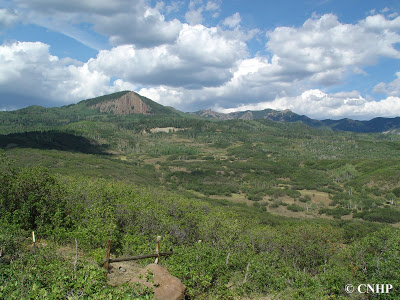
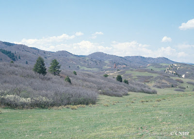
These are montane shrublands generally occurring at elevations from approximately 6,500 to 9,500 feet, where they are often situated above pinyon-juniper woodlands. Gambel oak is typically dominant, but very often mixed with other montane shrubs such as serviceberry, mountain mahogany, antelope bitterbrush, big sagebrush, chokecherry, and snowberry. This ecological system intergrades with the foothills shrubland system and shares many of the same site characteristics. In Colorado, oak and mixed mountain shrublands are most common on the west slope, where they form extensive bands on the lower mountain slopes, plateaus, and dry foothills. In eastern Colorado these shrublands are also found at the mountain front as far north as the Palmer Divide. These shrublands may form dense thickets, or occur as open shrublands with an herbaceous understory. Although this is a shrub-dominated system, some trees may be present. Fire typically plays an important role in this system, causing shrub die-back in some areas, promoting stump sprouting of the shrubs in other areas, and controlling the invasion of trees into the shrubland system.

 Oak shrubland (not leafed out yet) in Douglas County

As with foothills shrublands, there are few common or rare species exclusively associated with oak-mixed mountain shrublands. A variety of small mammals, including squirrels and woodrats, and birds such as rufous-sided towhee, green-tailed towhee, and Virginia’s warbler use these habitats. Larger mammals such as mule deer, black bear, and mountain lion may take advantage of the cover and food sources offered by thick shrublands.

These shrublands account for about 2.7 million acres in Colorado, more than 50% of it on privately owned land. Other substantial tracts are on state and federally owned lands, especially those managed by the US Forest Service and Bureau of Land Management, and occasionally within non-wilderness protected areas. These shrublands are weakly protected in Colorado, but are generally in good condition. Impacts include housing development and oil and gas development.

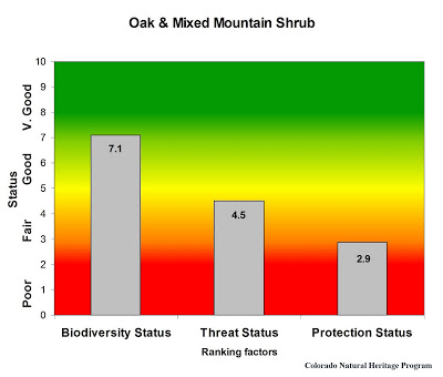
Overall biodiversity, threat, and protection status scores for oak shrublands in Colorado.

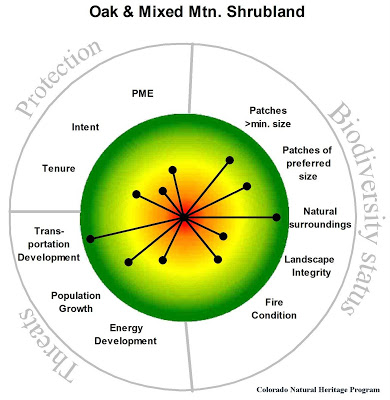
A “windrose” graph depicting oak shrubland status for individual scoring factors.

SHARE
FACEBOOK
TWITTER
LINKEDIN
REDDIT
EMAIL
Filed Under: Biodiversity Scorecard, Conservation Planning, Ecology

Two new county survey reports
New Report – Year 6 Weed Monitoring at the Air Force Academy

About Us

About Us
Conserving Biodiversity
Contact Us
Staff Directory
Careers
Employment
Internship
Volunteer
Meetings
The NatureServe Network
Partners

Our Work

Ecology
Wetlands
Plants
Animals
Climate Change
Education
Invasive Species

Blog Archive

Blog Categories

Web Projects

  • Rare Plant Guide Online
  • Colorado Wetland Info Center
  • COMaP - Colorado Protected Lands
  • Colorado Bat Working Group
  • STReaMS - Endangered Fishes Database

About Us

  • About Us
  • Conserving Biodiversity
  • Contact Us
  • Staff Directory
  • Careers
  • The NatureServe Network
  • Partners
  • Site Map
Warner College of Natural Resources Logo
  • Apply to CSU
  • Equal Opportunity
  • Disclaimer
  • Privacy Statement
  • Search CSU
  • CSU Land Acknowledgement
  • CSU Principles of Community
© 2026 Colorado Natural Heritage Program
Colorado State University Logo
  • About Us
    ▼
    • About Us
      ▼
      • Biennial Report
      • Strategic Plan
    • Conserving Biodiversity
    • Contact Us
    • Staff Directory
    • Careers
      ▼
      • Employment
      • Internship
      • Volunteer
    • Meetings
    • The NatureServe Network
    • Partners
  • Our Work
    ▼
    • Ecology
    • Wetlands
    • Plants
    • Animals
    • Climate Change
    • Education
    • Invasive Species
  • Our Services
    ▼
    • Database Development
    • GIS Analysis & Modeling
    • Mapping
    • Surveys & Inventories
    • Monitoring & Assessment
    • Conservation Planning
  • Our Data
    ▼
    • About CNHP Data
    • Request Data
    • Contribute Data
    • Download Data
    • Tracking Lists
    • PCA Reports
    • Help & Documentation
  • Maps
    ▼
    • CNHP Spatial Layers
    • Wetlands Mapper
    • COMaP
    • Conservation Environmental Review Tool
  • Library
    ▼
    • Reports
    • PCA Reports
    • Tracking Lists
    • Field Guides
      ▼
      • Rare Plant Guide
      • Colorado Wetland Field Guides
  • Blog
  • Donate Now