Colorado Natural Heritage Program Logo Colorado Natural Heritage Program Logo CNHP
  • About Us
    • About Us
      • Biennial Report
      • Strategic Plan
    • Conserving Biodiversity
    • Contact Us
    • Staff Directory
    • Careers
      • Employment
      • Internship
      • Volunteer
    • Meetings
    • The NatureServe Network
    • Partners
  • Our Work
    • Ecology
    • Wetlands
    • Plants
    • Animals
    • Climate Change
    • Education
    • Invasive Species
  • Our Services
    • Database Development
    • GIS Analysis & Modeling
    • Mapping
    • Surveys & Inventories
    • Monitoring & Assessment
    • Conservation Planning
  • Our Data
    • About CNHP Data
    • Request Data
    • Contribute Data
    • Download Data
    • Tracking Lists
    • PCA Reports
    • Help & Documentation
  • Maps
    • CNHP Spatial Layers
    • Wetlands Mapper
    • COMaP
    • Conservation Environmental Review Tool
  • Library
    • Reports
    • PCA Reports
    • Tracking Lists
    • Field Guides
      • Rare Plant Guide
      • Colorado Wetland Field Guides
  • Blog
  • Donate Now

Ecological Systems: Sandsage Shrubland

April 19, 2011

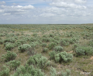
These shrublands dominate sandy areas on Colorado’s eastern plains, where they often intermingle with shortgrass prairie to form a locally patchy sandsage-shortgrass matrix. Occurrences are characterized by sand sagebrush with an understory of tall, mid- or short grasses and scattered forbs. Yucca and snakeweed are common in some areas. A variety of small mammals and burrowing reptiles live here where soils are easy to excavate. Typical species include kangaroo rats, plains pocket mice, grasshopper mice, western rattlesnakes, and western hognose snakes. Rarer species that are typical of this habitat include greater and lesser prairie-chickens, Cassin’s sparrows, and ornate box turtles.  Fire and grazing are the most important dynamic processes for sandsage ecosystems, although drought stress can impact this system significantly in some areas. 
Sand sage shrublands cover nearly two million acres in Colorado, and more than 80% of this is on private lands. State lands and federal lands managed by the US Forest Service account most for the remaining area. Although these sandy-soiled habitats have frequently been passed over while neighboring grasslands are converted to agriculture, and remaining tracts are generally in good condition, some 20% of historic coverage has been lost. The sand sage ecological system is poorly conserved in Colorado, with few patches in protected areas. These shrublands in Colorado are vulnerable to adverse impacts from energy development (including both wind and oil and gas).

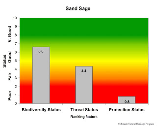
Overall biodiversity, threat, and protection status scores for sandsage in Colorado.
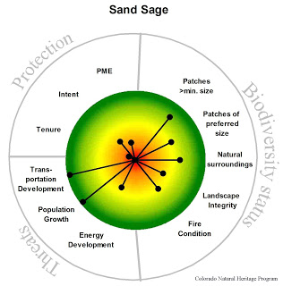
 A “windrose” graph depicting sandsage status for individual scoring factors.

SHARE
FACEBOOK
TWITTER
LINKEDIN
REDDIT
EMAIL
Filed Under: Biodiversity Scorecard, Conservation Planning, Ecology

Boulder County looking for volunteer plant monitors
New Report – Lowry Range Biological Survey 2010 Update

About Us

About Us
Conserving Biodiversity
Contact Us
Staff Directory
Careers
Employment
Internship
Volunteer
Meetings
The NatureServe Network
Partners

Our Work

Ecology
Wetlands
Plants
Animals
Climate Change
Education
Invasive Species

Blog Archive

Blog Categories

Web Projects

  • Rare Plant Guide Online
  • Colorado Wetland Info Center
  • COMaP - Colorado Protected Lands
  • Colorado Bat Working Group
  • STReaMS - Endangered Fishes Database

About Us

  • About Us
  • Conserving Biodiversity
  • Contact Us
  • Staff Directory
  • Careers
  • The NatureServe Network
  • Partners
  • Site Map
Warner College of Natural Resources Logo
  • Apply to CSU
  • Equal Opportunity
  • Disclaimer
  • Privacy Statement
  • Search CSU
  • CSU Land Acknowledgement
  • CSU Principles of Community
© 2026 Colorado Natural Heritage Program
Colorado State University Logo
  • About Us
    ▼
    • About Us
      ▼
      • Biennial Report
      • Strategic Plan
    • Conserving Biodiversity
    • Contact Us
    • Staff Directory
    • Careers
      ▼
      • Employment
      • Internship
      • Volunteer
    • Meetings
    • The NatureServe Network
    • Partners
  • Our Work
    ▼
    • Ecology
    • Wetlands
    • Plants
    • Animals
    • Climate Change
    • Education
    • Invasive Species
  • Our Services
    ▼
    • Database Development
    • GIS Analysis & Modeling
    • Mapping
    • Surveys & Inventories
    • Monitoring & Assessment
    • Conservation Planning
  • Our Data
    ▼
    • About CNHP Data
    • Request Data
    • Contribute Data
    • Download Data
    • Tracking Lists
    • PCA Reports
    • Help & Documentation
  • Maps
    ▼
    • CNHP Spatial Layers
    • Wetlands Mapper
    • COMaP
    • Conservation Environmental Review Tool
  • Library
    ▼
    • Reports
    • PCA Reports
    • Tracking Lists
    • Field Guides
      ▼
      • Rare Plant Guide
      • Colorado Wetland Field Guides
  • Blog
  • Donate Now