Colorado Natural Heritage Program Logo Colorado Natural Heritage Program Logo CNHP
  • About Us
    • About Us
      • Biennial Report
      • Strategic Plan
    • Conserving Biodiversity
    • Contact Us
    • Staff Directory
    • Careers
      • Employment
      • Internship
      • Volunteer
    • Meetings
    • The NatureServe Network
    • Partners
  • Our Work
    • Ecology
    • Wetlands
    • Plants
    • Animals
    • Climate Change
    • Education
    • Invasive Species
  • Our Services
    • Database Development
    • GIS Analysis & Modeling
    • Mapping
    • Surveys & Inventories
    • Monitoring & Assessment
    • Conservation Planning
  • Our Data
    • About CNHP Data
    • Request Data
    • Contribute Data
    • Download Data
    • Tracking Lists
    • PCA Reports
    • Help & Documentation
  • Maps
    • CNHP Spatial Layers
    • Wetlands Mapper
    • COMaP
    • Conservation Environmental Review Tool
  • Library
    • Reports
    • PCA Reports
    • Tracking Lists
    • Field Guides
      • Rare Plant Guide
      • Colorado Wetland Field Guides
  • Blog
  • Donate Now

Ecological Systems: Shrub-Steppe

March 10, 2011

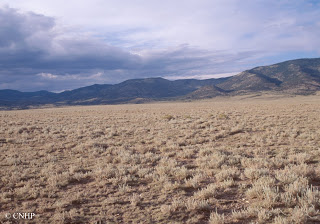
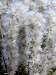
The term steppe generally refers to a treeless, grassy plain. In Colorado, these semi-arid shrubby grasslands are found between 7,500 and 9,500 feet in elevation, on windswept mesas, valley floors, gentle slopes, or shoulders of ridges. Our shrub-steppes are grass dominated areas with an open shrub layer. Typical grass species include blue grama, needle-and-thread, galleta, saltgrass, Indian rice grass, and alkali sacaton. Historically, the shrub layer was dominated by winterfat, but this species has decreased under pressure from domestic livestock grazing in many areas, and been replaced by rabbitbrush species and other woody shrubs. In Colorado, this system is generally a large-patch type, except in the San Luis Valley, where it can be matrix forming. The general aspect of occurrences may be either open shrubland with patchy grasses or patchy open herbaceous layer. Pinyon-juniper woodlands and sagebrush shrublands commonly are adjacent to this system at the upper elevations.

 Winterfat fruits

These shrub-steppes provide habitat for many shrubland birds and small mammals. Typical species include the sage thrasher, vesper sparrow, Gunnison’s prairie dog, Ord’s kangaroo rat, and northern grasshopper mouse. In the San Luis Valley, rare local subspecies of the silky pocket mouse and northern pocket gopher, as well as the rare plant species Weber’s cryptantha and James’s cryptantha, are found in these habitats.

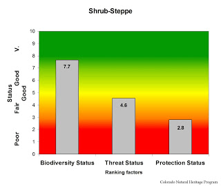
Shrub steppe currently covers more than 750,000 acres in Colorado. Historically it probably accounted for well over a million acres, but many of these areas have been converted to agricultural use. Remaining areas are generally in good condition, except for altered species composition. About half of our acreage is on privately owned lands, with the remainder primarily on federal land managed by the Bureau of Land Management, National Park Service, or US Fish and Wildlife Service. Few occurrances are within protected areas. Solar energy development, and continued alteration by domestic livestock grazing are the primary threats to this system.

Overall biodiversity, threat, and protection status scores for shrub-steppe in Colorado.
 
A “windrose” graph depicting shrub-steppe status for individual scoring factors.

SHARE
FACEBOOK
TWITTER
LINKEDIN
REDDIT
EMAIL
Filed Under: Biodiversity Scorecard, Conservation Planning, Ecology

Southeast Colorado Canyon Country Views
Job Posting: Student IT Technician

About Us

About Us
Conserving Biodiversity
Contact Us
Staff Directory
Careers
Employment
Internship
Volunteer
Meetings
The NatureServe Network
Partners

Our Work

Ecology
Wetlands
Plants
Animals
Climate Change
Education
Invasive Species

Blog Archive

Blog Categories

Web Projects

  • Rare Plant Guide Online
  • Colorado Wetland Info Center
  • COMaP - Colorado Protected Lands
  • Colorado Bat Working Group
  • STReaMS - Endangered Fishes Database

About Us

  • About Us
  • Conserving Biodiversity
  • Contact Us
  • Staff Directory
  • Careers
  • The NatureServe Network
  • Partners
  • Site Map
Warner College of Natural Resources Logo
  • Apply to CSU
  • Equal Opportunity
  • Disclaimer
  • Privacy Statement
  • Search CSU
  • CSU Land Acknowledgement
  • CSU Principles of Community
© 2026 Colorado Natural Heritage Program
Colorado State University Logo
  • About Us
    ▼
    • About Us
      ▼
      • Biennial Report
      • Strategic Plan
    • Conserving Biodiversity
    • Contact Us
    • Staff Directory
    • Careers
      ▼
      • Employment
      • Internship
      • Volunteer
    • Meetings
    • The NatureServe Network
    • Partners
  • Our Work
    ▼
    • Ecology
    • Wetlands
    • Plants
    • Animals
    • Climate Change
    • Education
    • Invasive Species
  • Our Services
    ▼
    • Database Development
    • GIS Analysis & Modeling
    • Mapping
    • Surveys & Inventories
    • Monitoring & Assessment
    • Conservation Planning
  • Our Data
    ▼
    • About CNHP Data
    • Request Data
    • Contribute Data
    • Download Data
    • Tracking Lists
    • PCA Reports
    • Help & Documentation
  • Maps
    ▼
    • CNHP Spatial Layers
    • Wetlands Mapper
    • COMaP
    • Conservation Environmental Review Tool
  • Library
    ▼
    • Reports
    • PCA Reports
    • Tracking Lists
    • Field Guides
      ▼
      • Rare Plant Guide
      • Colorado Wetland Field Guides
  • Blog
  • Donate Now