Colorado Natural Heritage Program Logo Colorado Natural Heritage Program Logo CNHP
  • About Us
    • About Us
      • Biennial Report
      • Strategic Plan
    • Conserving Biodiversity
    • Contact Us
    • Staff Directory
    • Careers
      • Employment
      • Internship
      • Volunteer
    • Meetings
    • The NatureServe Network
    • Partners
  • Our Work
    • Ecology
    • Wetlands
    • Plants
    • Animals
    • Climate Change
    • Education
    • Invasive Species
  • Our Services
    • Database Development
    • GIS Analysis & Modeling
    • Mapping
    • Surveys & Inventories
    • Monitoring & Assessment
    • Conservation Planning
  • Our Data
    • About CNHP Data
    • Request Data
    • Contribute Data
    • Download Data
    • Tracking Lists
    • PCA Reports
    • Help & Documentation
  • Maps
    • CNHP Spatial Layers
    • Wetlands Mapper
    • COMaP
    • Conservation Environmental Review Tool
  • Library
    • Reports
    • PCA Reports
    • Tracking Lists
    • Field Guides
      • Rare Plant Guide
      • Colorado Wetland Field Guides
  • Blog
  • Donate Now

Ecological Systems: Greasewood

February 8, 2011

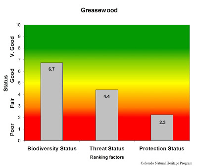
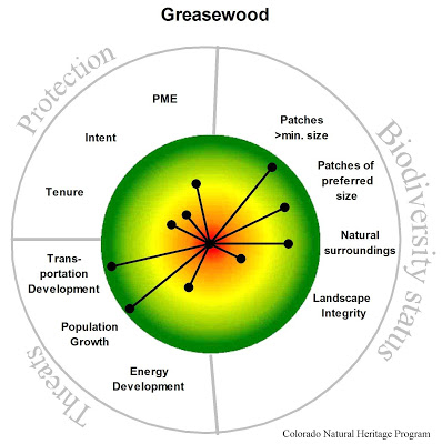
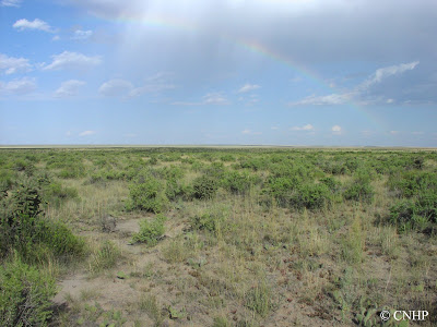
The Greasewood ecological system accounts for less than 450,000 acres in Colorado, where it is typically found near drainages on stream terraces and flats, on alluvial fans along streams or arroyos, or as rings around playas. In eastern Colorado, occurrences are primarily in the southwestern portion of the plains. Large occurrences are also found in the lower elevations of Colorado’s western valleys and throughout much of the San Luis Valley. Elevations range from about 4,000 to 7,700 feet. Greasewood flats usually have saline soils, a shallow water table and flood intermittently, but remain dry for most of the growing season. These open to moderately dense shrublands are dominated by black greasewood, often with additional shrubs and graminoids that tolerate saline soils.

Greasewood stands are used by some shrubland birds, such as the sage thrasher, and small mammals including the white-tailed antelope squirrel. In the San Luis Valley, these shrublands are home to rare local subspecies of the silky pocket mouse and thirteen lined ground squirrel. Here also the rare slender spiderflower occurs in alkaline playa wetlands that are imbedded in greasewood flats. Some large tracts of greasewood shrubland are included within federally owned lands managed by the National Park Service, the U.S. Fish and Wildlife Service, or the Bureau of Land Management, but are generally not part of protected areas. Occurrences of this system are threatened primarily by agricultural and energy development.

Overall biodiversity, threat, and protection status scores for greasewood in Colorado.

A “windrose” graph depicting greasewood status for individual scoring factors.

SHARE
FACEBOOK
TWITTER
LINKEDIN
REDDIT
EMAIL
Filed Under: Biodiversity Scorecard, Conservation Planning, Ecology

Online Rare Plant Guide updated
One more job posting

About Us

About Us
Conserving Biodiversity
Contact Us
Staff Directory
Careers
Employment
Internship
Volunteer
Meetings
The NatureServe Network
Partners

Our Work

Ecology
Wetlands
Plants
Animals
Climate Change
Education
Invasive Species

Blog Archive

Blog Categories

Web Projects

  • Rare Plant Guide Online
  • Colorado Wetland Info Center
  • COMaP - Colorado Protected Lands
  • Colorado Bat Working Group
  • STReaMS - Endangered Fishes Database

About Us

  • About Us
  • Conserving Biodiversity
  • Contact Us
  • Staff Directory
  • Careers
  • The NatureServe Network
  • Partners
  • Site Map
Warner College of Natural Resources Logo
  • Apply to CSU
  • Equal Opportunity
  • Disclaimer
  • Privacy Statement
  • Search CSU
  • CSU Land Acknowledgement
  • CSU Principles of Community
© 2026 Colorado Natural Heritage Program
Colorado State University Logo
  • About Us
    ▼
    • About Us
      ▼
      • Biennial Report
      • Strategic Plan
    • Conserving Biodiversity
    • Contact Us
    • Staff Directory
    • Careers
      ▼
      • Employment
      • Internship
      • Volunteer
    • Meetings
    • The NatureServe Network
    • Partners
  • Our Work
    ▼
    • Ecology
    • Wetlands
    • Plants
    • Animals
    • Climate Change
    • Education
    • Invasive Species
  • Our Services
    ▼
    • Database Development
    • GIS Analysis & Modeling
    • Mapping
    • Surveys & Inventories
    • Monitoring & Assessment
    • Conservation Planning
  • Our Data
    ▼
    • About CNHP Data
    • Request Data
    • Contribute Data
    • Download Data
    • Tracking Lists
    • PCA Reports
    • Help & Documentation
  • Maps
    ▼
    • CNHP Spatial Layers
    • Wetlands Mapper
    • COMaP
    • Conservation Environmental Review Tool
  • Library
    ▼
    • Reports
    • PCA Reports
    • Tracking Lists
    • Field Guides
      ▼
      • Rare Plant Guide
      • Colorado Wetland Field Guides
  • Blog
  • Donate Now