Colorado Natural Heritage Program Logo Colorado Natural Heritage Program Logo CNHP
  • About Us
    • About Us
      • Biennial Report
      • Strategic Plan
    • Conserving Biodiversity
    • Contact Us
    • Staff Directory
    • Careers
      • Employment
      • Internship
      • Volunteer
    • Meetings
    • The NatureServe Network
    • Partners
  • Our Work
    • Ecology
    • Wetlands
    • Plants
    • Animals
    • Climate Change
    • Education
    • Invasive Species
  • Our Services
    • Database Development
    • GIS Analysis & Modeling
    • Mapping
    • Surveys & Inventories
    • Monitoring & Assessment
    • Conservation Planning
  • Our Data
    • About CNHP Data
    • Request Data
    • Contribute Data
    • Download Data
    • Tracking Lists
    • PCA Reports
    • Help & Documentation
  • Maps
    • CNHP Spatial Layers
    • Wetlands Mapper
    • COMaP
    • Conservation Environmental Review Tool
  • Library
    • Reports
    • PCA Reports
    • Tracking Lists
    • Field Guides
      • Rare Plant Guide
      • Colorado Wetland Field Guides
  • Blog
  • Donate Now

March of the Chollas

September 30, 2010

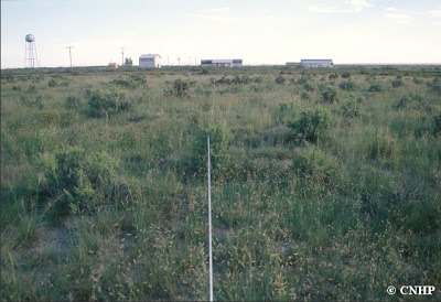
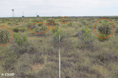
The cholla cactus (Cylindropuntia imbricata) is a fairly common sight in the Arkansas River basin of southeast Colorado, where it can occur as scattered individuals or in fairly dense stands. Eleven years after first monitoring cholla cactus and other shrubs at the Pueblo Chemical Depot (PCD), in Pueblo County, CHNP ecologist Renée Rondeau has documented a significant increase in cholla density in the greasewood shrubland at the site.

Cylindropuntia imbricata
Anyone else hear that music from The Sorcerer’s Apprentice?

In 1999 chollas averaged 550 individuals/hectare. By 2010, cholla density had increased to 720 individuals/hectare. Half of the plots were grazed by cattle up until 1998 while the other half have not been grazed since 1945; there was no difference in cholla densities between grazed/ungrazed plots.

graph of average cholla density over time
Mean cholla densities for each year of monitoring. Bars show one standard error.

So why the increase in cholla density? Renée and others will be looking into this during the winter months, investigating climate changes as well as management changes. If anyone has any ideas about what might have caused this increase in chollas, feel free to leave a comment below, or email your thoughts to Renée (email can be found on our Contacts page).

Photograph of one of the transects at PCD in 1999. A few chollas are visible in the distance.

The same transect in 2010. The circles highlight “new” chollas. (Note: the buildings visible in 1998 were dismantled, but the water tower is still present.)

SHARE
FACEBOOK
TWITTER
LINKEDIN
REDDIT
EMAIL
Filed Under: Ecology

Teller for Tomorrow forum October 16
New Report: Lesser Prairie Chicken Habitat Assessment at the Comanche National Grasslands

About Us

About Us
Conserving Biodiversity
Contact Us
Staff Directory
Careers
Employment
Internship
Volunteer
Meetings
The NatureServe Network
Partners

Our Work

Ecology
Wetlands
Plants
Animals
Climate Change
Education
Invasive Species

Blog Archive

Blog Categories

Web Projects

  • Rare Plant Guide Online
  • Colorado Wetland Info Center
  • COMaP - Colorado Protected Lands
  • Colorado Bat Working Group
  • STReaMS - Endangered Fishes Database

About Us

  • About Us
  • Conserving Biodiversity
  • Contact Us
  • Staff Directory
  • Careers
  • The NatureServe Network
  • Partners
  • Site Map
Warner College of Natural Resources Logo
  • Apply to CSU
  • Equal Opportunity
  • Disclaimer
  • Privacy Statement
  • Search CSU
  • CSU Land Acknowledgement
  • CSU Principles of Community
© 2026 Colorado Natural Heritage Program
Colorado State University Logo
  • About Us
    ▼
    • About Us
      ▼
      • Biennial Report
      • Strategic Plan
    • Conserving Biodiversity
    • Contact Us
    • Staff Directory
    • Careers
      ▼
      • Employment
      • Internship
      • Volunteer
    • Meetings
    • The NatureServe Network
    • Partners
  • Our Work
    ▼
    • Ecology
    • Wetlands
    • Plants
    • Animals
    • Climate Change
    • Education
    • Invasive Species
  • Our Services
    ▼
    • Database Development
    • GIS Analysis & Modeling
    • Mapping
    • Surveys & Inventories
    • Monitoring & Assessment
    • Conservation Planning
  • Our Data
    ▼
    • About CNHP Data
    • Request Data
    • Contribute Data
    • Download Data
    • Tracking Lists
    • PCA Reports
    • Help & Documentation
  • Maps
    ▼
    • CNHP Spatial Layers
    • Wetlands Mapper
    • COMaP
    • Conservation Environmental Review Tool
  • Library
    ▼
    • Reports
    • PCA Reports
    • Tracking Lists
    • Field Guides
      ▼
      • Rare Plant Guide
      • Colorado Wetland Field Guides
  • Blog
  • Donate Now