Colorado Natural Heritage Program Logo Colorado Natural Heritage Program Logo CNHP
  • About Us
    • About Us
      • Biennial Report
      • Strategic Plan
    • Conserving Biodiversity
    • Contact Us
    • Staff Directory
    • Careers
      • Employment
      • Internship
      • Volunteer
    • Meetings
    • The NatureServe Network
    • Partners
  • Our Work
    • Ecology
    • Wetlands
    • Plants
    • Animals
    • Climate Change
    • Education
    • Invasive Species
  • Our Services
    • Database Development
    • GIS Analysis & Modeling
    • Mapping
    • Surveys & Inventories
    • Monitoring & Assessment
    • Conservation Planning
  • Our Data
    • About CNHP Data
    • Request Data
    • Contribute Data
    • Download Data
    • Tracking Lists
    • PCA Reports
    • Help & Documentation
  • Maps
    • CNHP Spatial Layers
    • Wetlands Mapper
    • COMaP
    • Conservation Environmental Review Tool
  • Library
    • Reports
    • PCA Reports
    • Tracking Lists
    • Field Guides
      • Rare Plant Guide
      • Colorado Wetland Field Guides
  • Blog
  • Donate Now

Groundtruthing wetland mapping

June 17, 2010

As a part of our Setting Mitigation in the Watershed Context project, we are attempting to use aerial imagery to not only locate wetlands, but to classify them by type. Wetlands are frequently difficult to identify from a distance, and manual photo interpretation can be very time consuming. We hope to eventually use our manual photo interpretation results as training data for pattern recognition software. For our imagery, we are using National Agriculture Imagery Program (NAIP) digital aerial photos taken in 2009. The images are at 1 meter resolution and cover about 1,300 square miles of the Cache La Poudre, Big Thompson, and South Platte River watersheds in northern Colorado. The near infra-red color band of these photos is especially helpful in identifying wetlands, however, NAIP flight-lines are typically flown in the summer, when the leaves on deciduous trees can obscure what occurs underneath.
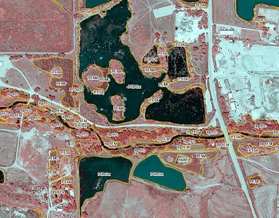
An example of NAIP near-infrared imagery overlaid with mapped wetlands
identified by type.

Because even the best photo interpreter can have false positives (identifying irrigated hayfields or stock ponds as wetlands), or false negatives (missing wetlands due to leaves obscuring the image), we have been groundtruthing several locations within the project area in order to help refine our search pattern.

One of the wetlands recently visited during groundtruthing.

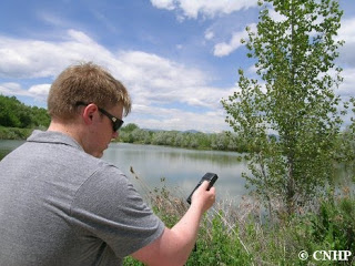
CNHP GIS Analyst Zack Reams and Ecology Technician Ellen Heath recently went out on a groundtruthing excursion. Using their trusty GPS for navigation, they visited several tentative wetland signatures near urban areas. The first area they went to, east of the Centerra Mall in Windsor, turned out to be a stormwater catchment area and not an actual wetland, but they were able to confirm the remaining sites as actual wetlands.

Zack consulting a print-out of NAIP imagery to see if he’s near
the wetland he’s looking for. Photo by Ellen Heath.

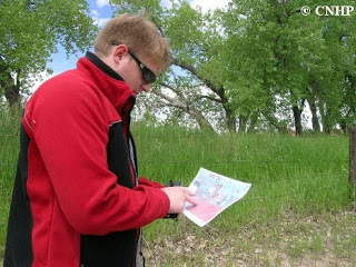
Zack linked his collected GPS coordinates with the digital photos Ellen took at each site so that pictures of the visited areas can be stored with their spatial coordinates in a Geographic Information System as a part of the groundtruthing validation process.

Zack getting a GPS waypoint. (Ellen has the camera, so there aren’t any pictures of her!)
Photo by Ellen Heath.

SHARE
FACEBOOK
TWITTER
LINKEDIN
REDDIT
EMAIL
Filed Under: Ecology, GIS, Wetlands

SE Colorado Canyonlands Bioblitz – Results
Two new zoology publications

About Us

About Us
Conserving Biodiversity
Contact Us
Staff Directory
Careers
Employment
Internship
Volunteer
Meetings
The NatureServe Network
Partners

Our Work

Ecology
Wetlands
Plants
Animals
Climate Change
Education
Invasive Species

Blog Archive

Blog Categories

Web Projects

  • Rare Plant Guide Online
  • Colorado Wetland Info Center
  • COMaP - Colorado Protected Lands
  • Colorado Bat Working Group
  • STReaMS - Endangered Fishes Database

About Us

  • About Us
  • Conserving Biodiversity
  • Contact Us
  • Staff Directory
  • Careers
  • The NatureServe Network
  • Partners
  • Site Map
Warner College of Natural Resources Logo
  • Apply to CSU
  • Equal Opportunity
  • Disclaimer
  • Privacy Statement
  • Search CSU
  • CSU Land Acknowledgement
  • CSU Principles of Community
© 2026 Colorado Natural Heritage Program
Colorado State University Logo
  • About Us
    ▼
    • About Us
      ▼
      • Biennial Report
      • Strategic Plan
    • Conserving Biodiversity
    • Contact Us
    • Staff Directory
    • Careers
      ▼
      • Employment
      • Internship
      • Volunteer
    • Meetings
    • The NatureServe Network
    • Partners
  • Our Work
    ▼
    • Ecology
    • Wetlands
    • Plants
    • Animals
    • Climate Change
    • Education
    • Invasive Species
  • Our Services
    ▼
    • Database Development
    • GIS Analysis & Modeling
    • Mapping
    • Surveys & Inventories
    • Monitoring & Assessment
    • Conservation Planning
  • Our Data
    ▼
    • About CNHP Data
    • Request Data
    • Contribute Data
    • Download Data
    • Tracking Lists
    • PCA Reports
    • Help & Documentation
  • Maps
    ▼
    • CNHP Spatial Layers
    • Wetlands Mapper
    • COMaP
    • Conservation Environmental Review Tool
  • Library
    ▼
    • Reports
    • PCA Reports
    • Tracking Lists
    • Field Guides
      ▼
      • Rare Plant Guide
      • Colorado Wetland Field Guides
  • Blog
  • Donate Now