Colorado Natural Heritage Program Logo Colorado Natural Heritage Program Logo CNHP
  • About Us
    • About Us
      • Biennial Report
      • Strategic Plan
    • Conserving Biodiversity
    • Contact Us
    • Staff Directory
    • Careers
      • Employment
      • Internship
      • Volunteer
    • Meetings
    • The NatureServe Network
    • Partners
  • Our Work
    • Ecology
    • Wetlands
    • Plants
    • Animals
    • Climate Change
    • Education
    • Invasive Species
  • Our Services
    • Database Development
    • GIS Analysis & Modeling
    • Mapping
    • Surveys & Inventories
    • Monitoring & Assessment
    • Conservation Planning
  • Our Data
    • About CNHP Data
    • Request Data
    • Contribute Data
    • Download Data
    • Tracking Lists
    • PCA Reports
    • Help & Documentation
  • Maps
    • CNHP Spatial Layers
    • Wetlands Mapper
    • COMaP
    • Conservation Environmental Review Tool
  • Library
    • Reports
    • PCA Reports
    • Tracking Lists
    • Field Guides
      • Rare Plant Guide
      • Colorado Wetland Field Guides
  • Blog
  • Donate Now

Rocky Mountain ReMAP project

October 15, 2009

 The multi-state ReMAP project team lays out a survey plot during pre-season training in Lander Wyoming.

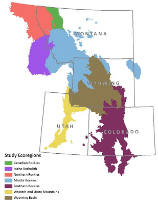
CNHP is partnering with the Montana Natural Heritage Program and the Wyoming Natural Diversity Database on an exciting large-scale project that will aid all three states in refining wetland condition assessment methodology. The project, funded by the EPA’s Regional Monitoring and Assessment Program (ReMAP for short), is called the Rocky Mountain ReMAP project and provides an opportunity to compare wetlands across the Rocky Mountains.

Over the course of the three-year project period (2008-2011), the project will:
1.  Identify reference standards for six wetland ecological systems found across the Rocky Mountain region
2.  Develop Level I, II and III protocols for evaluating the ecological condition of six wetland ecological systems throughout the study area.
3.  Produce a regionally standardized method for assessing and monitoring wetland condition, including quality assurance project plans, sampling strategies, and metrics calibrated to the six different wetland ecological systems.

 Linda Vance, project lead from the Montana Natural Heritage Program, discusses protocols for estimating bankfull width during pre-season training in Lander, Wyoming.

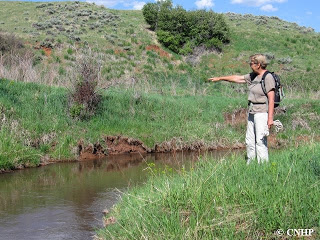
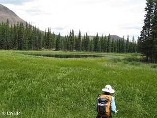
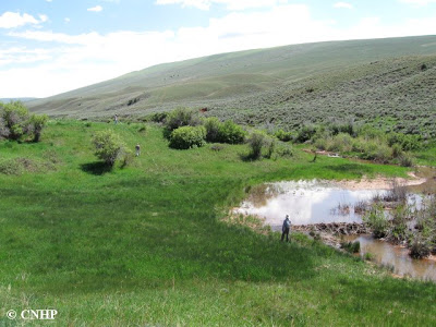
Data collection for this project began this past field season, and will continue through next year. The CNHP field crew traveled to wetlands throughout the mountainous portions of Colorado, including the West Elk Mountains near Gunnison, the Sawatch Range near Buena Vista, and the Mt. Zirkel Wilderness near Steamboat Spring. Though they put many miles on the field vehicle, CNHP crew members Elin Franzen and Hannah Varani, both recent CSU graduates, were thrilled to see so many different and beautiful wetlands across the state.

CNHP ReMAP field crew member Elin Franzen prepares to survey a high elevation marsh in Chaffee County.

SHARE
FACEBOOK
TWITTER
LINKEDIN
REDDIT
EMAIL
Filed Under: Collaborations, Ecology, Wetlands

Preble's meadow jumping mouse at the U.S. Air Force Academy
Renée Rondeau receives award from CSU

About Us

About Us
Conserving Biodiversity
Contact Us
Staff Directory
Careers
Employment
Internship
Volunteer
Meetings
The NatureServe Network
Partners

Our Work

Ecology
Wetlands
Plants
Animals
Climate Change
Education
Invasive Species

Blog Archive

Blog Categories

Web Projects

  • Rare Plant Guide Online
  • Colorado Wetland Info Center
  • COMaP - Colorado Protected Lands
  • Colorado Bat Working Group
  • STReaMS - Endangered Fishes Database

About Us

  • About Us
  • Conserving Biodiversity
  • Contact Us
  • Staff Directory
  • Careers
  • The NatureServe Network
  • Partners
  • Site Map
Warner College of Natural Resources Logo
  • Apply to CSU
  • Equal Opportunity
  • Disclaimer
  • Privacy Statement
  • Search CSU
  • CSU Land Acknowledgement
  • CSU Principles of Community
© 2026 Colorado Natural Heritage Program
Colorado State University Logo
  • About Us
    ▼
    • About Us
      ▼
      • Biennial Report
      • Strategic Plan
    • Conserving Biodiversity
    • Contact Us
    • Staff Directory
    • Careers
      ▼
      • Employment
      • Internship
      • Volunteer
    • Meetings
    • The NatureServe Network
    • Partners
  • Our Work
    ▼
    • Ecology
    • Wetlands
    • Plants
    • Animals
    • Climate Change
    • Education
    • Invasive Species
  • Our Services
    ▼
    • Database Development
    • GIS Analysis & Modeling
    • Mapping
    • Surveys & Inventories
    • Monitoring & Assessment
    • Conservation Planning
  • Our Data
    ▼
    • About CNHP Data
    • Request Data
    • Contribute Data
    • Download Data
    • Tracking Lists
    • PCA Reports
    • Help & Documentation
  • Maps
    ▼
    • CNHP Spatial Layers
    • Wetlands Mapper
    • COMaP
    • Conservation Environmental Review Tool
  • Library
    ▼
    • Reports
    • PCA Reports
    • Tracking Lists
    • Field Guides
      ▼
      • Rare Plant Guide
      • Colorado Wetland Field Guides
  • Blog
  • Donate Now