



Biodiversity Indicators Program
The Biodiversity Indicators Program (BIP) supports the protection and recovery of focal species, key biodiversity areas, and hotspots.
The Program produces and facilitates access to biodiversity data, information products, and indicators that transform core data into conservation intelligence. Through data aggregation and visualizations, the BIP builds monitoring and reporting capacity across multiple partner scales, including sub-national entities, nation-states, and United Nations organizations.
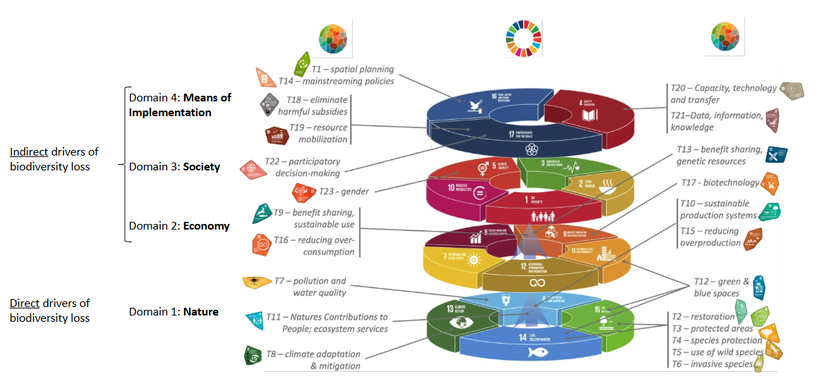
In alignment with the Global Biodiversity Framework (GBF) and the Sustainable Development Goals (SDGs). At its core, the Biodiversity Indicators Program improves the mainstreaming of biodiversity information by strengthening capacity, understanding, and communication of biodiversity-related targets established by the Kunming-Montreal Global Biodiversity Framework through the Convention on Biological Diversity (CBD) (Figure 1).
Program History
The Biodiversity Indicators Program originated at NatureServe, initially funded by a MacArthur Foundation grant to develop a dashboard visualizing biodiversity indicators. While NatureServe’s mission focuses on North America, the Warner College of Natural Resources within Colorado State University (CSU) has a global focus. The Biodiversity Indicators Program migrated to its new home at CSU in 2024 and remains in the NatureServe Network of Natural Heritage Programs through its placement within the Colorado Natural Heritage Program.
Evidence-based Biodiversity Indicators Dashboards
While the Global Biodiversity Information Facility (GBIF) has made an extraordinary volume of species occurrence data available, many users still face challenges in applying appropriate quality control, filtering, and data preparation before those records can be used in spatial analysis or decision support. The 5th National Reports of the Convention on Biological Diversity (CBD) show that only 20% of current indicators matched the CBD recommendations for utilizing national-level datasets (Bhatt et al. 2020). Leveraging nationally-generated indicators can improve stocktaking and tracking but presents challenges for interoperability and reporting to the global level.
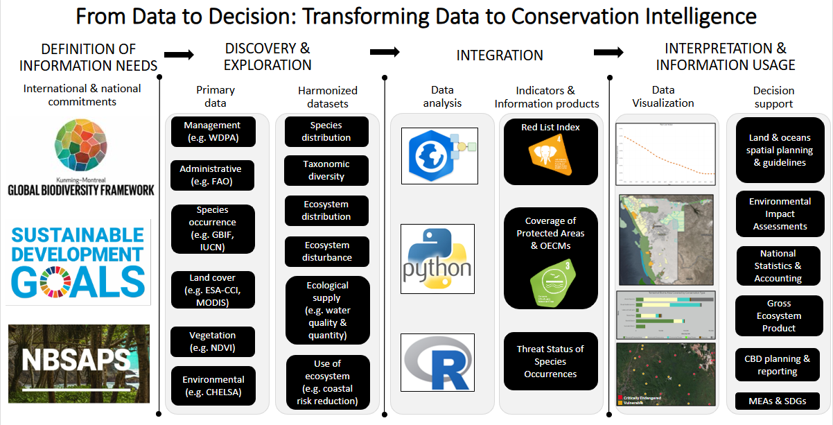
To address this, the BIP focuses on consistent interpretation of biodiversity data at the local, national, and international scales by providing repeatable workflows aligning with the global CBD framework indicators. These workflows are applied to similar datasets to clean reference data, derive visualizations, and track changes over time.(Figure 2)
The BIP uses a custom, python-based ArcGIS toolbox that processes GBF occurrence datasets for visualization on interactive dashboards. The BIP ArcGIS GBIF Processing Toolbox addresses a critical gap between data access and data usability. This in-house capacity, developed in collaboration with NatureServe, allows the BIP to support partners in generating defensible, repeatable biodiversity datasets.
Sustainable Platforms for a Sustainable World
To meet KM-GBF Target 21 (Ensure That Knowledge Is Accessible to Guide Biodiversity Action), the BIP specializes in visualizing biodiversity data and indicators on interactive platforms.
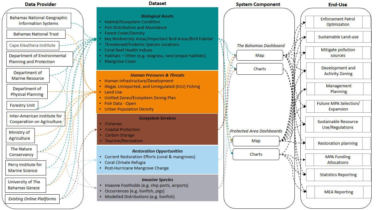
The BIP receives datasets from partners on biological assets, human pressure and threats, ecosystem services, restoration opportunities, and invasive species. These data can then be used in decision-making, communication, and collaboration on conservation actions that achieve priority biodiversity outcomes. The BIP uses accessible and inclusive geospatial tools that ensures partners can maintain and evolve their BIP-developed platforms over time. Further, the Program implements in-person and virtual training to engage with the experts within the organizations hosting the platforms.
After development, partners can maintain and evolve the platforms (e.g., by updating or enhancing their datasets) to ensure long-term usability and to reflect advancements in data availability and interoperability.
Where We Work
The Biodiversity Indicators Program supports national and regional uptake of biodiversity indicators, information products and spatial reference layers by partnering with intergovernmental entities around the world. Regional partnerships include the Association of Southeast Asian Nations (a consortium of 10 member states including Vietnam) and the Arctic Council (an intergovernmental forum of 8 Arctic states) and national partnerships include those within Ghana, Uganda, Namibia, South Korea and The Bahamas.







Contact Us
Biodiversity Indicators Program Director: Vinamra Mathur
Literature Cited
Bhatt, Rashi., Gill, Michael J., Hamilton, Healy, Han, Xuemei, Linden, Ellie, Young, Bruce E. (2020) Uneven use of biodiversity indicators in 5th National Reports to the Convention on Biological Diversity. Environmental Conservation 47: 15–21. doi: 10.1017/S0376892919000365
Kim, HyeJin, Navarro, Laetitia, Balvanera, Patricia, Campbell, Jillian, Chaplin-Kramer, Rebecca, Child, Matthew, Ferrier, Simon, Geller, Gary, Gill, Mike, Krug, Cornelia, Millette, Katie L., Muller-Karger, Frank E., Pereira, Henrique (2020). Essential Biodiversity Variables and Essential Ecosystem Services Variables for the Implementation of Biodiversity Conservation and Sustainable Development Goals. EcoEvoRxix Preprint.
Obura, David (2023). The Kunming-Montreal Global Biodiversity Framework: Business as usual or a turning point? One Earth: 6 (2)